
El Nuevo Día is the newspaper with the largest circulation in Puerto Rico. It is considered mainstream and the territory's newspaper of record. It was founded in 1909 in Ponce, Puerto Rico, and today it is a subsidiary of GFR Media. Its headquarters are in Guaynabo, Puerto Rico.

Guaynabo is a city, suburb of San Juan and municipality in the northern part of Puerto Rico, located in the northern coast of the island, north of Aguas Buenas, south of Cataño, east of Bayamón, and west of San Juan. Guaynabo is spread over 9 barrios and Guaynabo Pueblo. Guaynabo is considered, along with its neighbors – San Juan and the municipalities of Bayamón, Carolina, Cataño, Trujillo Alto, and Toa Baja – to be part of the San Juan metropolitan area. It is also part of the larger San Juan-Caguas-Guaynabo Metropolitan Statistical Area,.

Caguax was a Taíno cacique who lived on the island of Borikén before and during the Spanish colonization of the Americas. The name of his yucayeque, or Taino village, was Turabo; it comprised the Caguas Valley and surrounding mountains. This area today comprises the modern municipalities of Caguas, Aguas Buenas, Gurabo, and portions of San Lorenzo, Juncos and Las Piedras in east-central Puerto Rico. Guaybanex Caguax was an early convert to the Catholic faith; he adopted the Spanish name Francisco at the time of his baptism. His high rank in Taino society allowed him to also retain his Taino names, Guaybanex, and his surname, Caguax. Francisco Guaybanex Caguax sought to avoid conflict with the Spanish; as a powerful chief in the northern slopes and plains of the island he understood the heavy toll his people would suffer if they were to oppose the Spanish rule, and he sought peaceful ways to deal with the situation. As early as 1508, Caguax cooperated with the colonists’ requests for labor and a food supply. In 1511, he was one of only two chiefs who accepted the peace terms that the Spanish had offered a few months after the Taino Revolt started. In 1512, he was taken captive and transported to Hacienda del Toa. There he was humiliated before his nitainos by being forced to become the governor's personal servant. Caguax died in captivity in 1518 or early 1519. He was succeeded by his daughter, Maria Bagaaname.

Old San Juan is a historic district located at the "northwest triangle" of the islet of San Juan in San Juan. Its area roughly correlates to the Ballajá, Catedral, Marina, Mercado, San Cristóbal, and San Francisco sub-barrios (sub-districts) of barrio San Juan Antiguo in the municipality of San Juan, Puerto Rico. Old San Juan is the oldest settlement within Puerto Rico and the historic colonial district of the city of San Juan. This historic district is a National Historic Landmark District named Zona Histórica de San Juan and is listed on the United States National Register of Historic Places as the Old San Juan Historic District. Several historical buildings and structures, particularly La Fortaleza, the city walls, and El Morro and San Cristóbal castles, have been inscribed in the UNESCO World Heritage Site list since 1983. Historically the mixed-use commercial and residential real estate in the main streets of Calle Cristo and Calle Fortaleza from Calle Tanca to the Governor’s Mansion is the most valuable in the area and it has kept its value and increased steadily through several years despite the past economic turmoils.
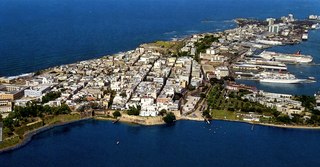
San Juan Islet is a 3-square-mile (7.8 km2) islet or small island on San Juan Bay in the Atlantic coast of northern Puerto Rico. Home to Old San Juan, it is the site of the oldest permanent European settlement in Puerto Rico (1521), and the second oldest European settlement in the West Indies after Santo Domingo (1496). Due to its strategic location in the Caribbean during the Spanish colonization of the Americas, it is home to a city wall and a number of militaristic buildings such as El Morro Castle. Today, it is also home to many of Puerto Rico's government buildings such as the territory's capitol building.

Agüeybaná II, born Güeybaná and also known as Agüeybaná El Bravo, was one of the two principal and most powerful caciques of the Taíno people in Borikén when the Spaniards first arrived in Puerto Rico on November 19, 1493. Agüeybaná II led the Taínos of Puerto Rico in the Battle of Yagüecas, also known as the Taíno rebellion of 1511, against Juan Ponce de León and the Spanish Conquistadors.

The Museo de la Masacre de Ponce is a human rights museum and historic building in Ponce, Puerto Rico. It depicts the history and events surrounding the Ponce massacre, which occurred in broad daylight on Palm Sunday in 1937. The museum is housed inside the building where the event itself occurred, with one of its sections devoted to the Nationalist leader, Pedro Albizu Campos. It also documents the blacklisting of Puerto Rican Nationalists performed by the United States, as well as hosting a considerable number of photos from the Nationalist era.

The Panteón Nacional Román Baldorioty de Castro is a tract of land in Barrio Segundo of the city of Ponce, Puerto Rico, originally designed as the city's cemetery, but later converted into what has come to be a famous burial place. Established in 1842, it is Puerto Rico's first national pantheon. It is the only cemetery dedicated as a museum in Puerto Rico and the Caribbean. Prior to being dedicated as a Panteón Nacional, it was known as Cementerio Viejo or as Cementerio Antiguo de Ponce, and is listed under that name on the U.S. National Register of Historic Places. The Pantheon is named after Román Baldorioty de Castro, a prolific Puerto Rican politician, and firm believer of Puerto Rican autonomy and independence. His remains are located here. The Pantheon also houses a small museum about the history of autonomism in the Island, and it is currently used both as a park and a venue for the expression of culture and the arts. It is called the Museo del Autonomismo Puertorriqueño.

The Museo de la Música Puertorriqueña is a museum in Ponce, Puerto Rico, that showcases the development of Puerto Rican music, with displays of Taíno, Spanish, and African musical instruments that were played in the romantic danza genre, the favorite music of 19th-century Puerto Rican high society, as well as the more African-inspired bomba and plena styles. Also on display are memorabilia of composers and performers. The Museum traces the rich musical history of Puerto Rico through memorabilia of prominent musicians and displays of the musical instruments associated with the three genres of music that originated in this Caribbean island.
José de Toro was Mayor of Ponce, Puerto Rico, in two occasions: 1814 and in 1820. In 1814, he performed as a teniente a guerra mayor, while from 3 June 1820 until later that year he performed as Alcalde ordinario.

Pueblo Viejo is a barrio in the municipality of Guaynabo, Puerto Rico. Its population in 2010 was 23,816.

San Juan Bay is the bay and main inlet adjacent to Old San Juan in northeastern Puerto Rico. It is about 3.5 miles (5.6 km) in length, the largest body of water in an estuary of about 97 square miles (250 km2) of channels, inlets and eight interconnected lagoons. The San Juan Bay is home to the island's busiest harbor and its history dates back to at least 1508.
Alejandro Ordóñez was Mayor of Ponce, Puerto Rico, from 3 January 1816 to 31 December 1818. He was a teniente justicia mayor.
Joaquín Tellechea was an hacendado and Spanish Army sergeant major who served as the 17th mayor of Ponce, Puerto Rico, in 1821. Tellechea was a sergeant major and also owned a 90-cuerda sugar cane hacienda in the Los Caños sector in Ponce.

Fundación Biblioteca Rafael Hernández Colón is a gubernatorial library and museum that records the political life of three-term governor of Puerto Rico, Rafael Hernández Colón. It was founded in 1992 and in September 2015 it moved to its current location at the southeast corner of Calle Mayor and Calle Castillo in Ponce, Puerto Rico, in the Ponce Historic Zone.
Vasco Porcallo de Figueroa was a Spanish conquistador. He played a significant role in the early colonization of the Americas, including the subjugation of the Higüey and Jaragua provinces under Nicolás de Ovando's governorship in Santo Domingo. Porcallo de Figueroa founded several settlements in Cuba, including Sancti Spíritus and what later became Remedios, but in the time after its founding was called "Santa Cruz de la Savana de Vasco Porcallo". He became notorious for his brutal treatment of the indigenous Siboneyes, and is also recognized for importing the first African slaves to Cuba.


