Lower Merion Township is a township in Montgomery County, Pennsylvania and part of the Philadelphia Main Line. The township's name originates with the county of Merioneth in north Wales. Merioneth is an English-language transcription of the Welsh Meirionnydd.

Wyncote is a census-designated place (CDP) in Cheltenham Township, Montgomery County, Pennsylvania, United States. It borders the northwestern and northeastern section of Philadelphia. Wyncote is located 11 miles from Center City Philadelphia at the southeasternmost tip of Montgomery County. The Jenkintown-Wyncote SEPTA station is the fifth busiest regional rail station in the SEPTA system.
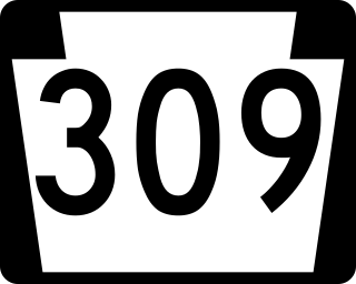
Pennsylvania Route 309 is a state highway that runs for 134 miles (216 km) through eastern Pennsylvania. The route runs from an interchange between PA 611 and Cheltenham Avenue on the border of Philadelphia and Cheltenham Township north to an intersection with PA 29 in Bowman Creek, a village in Monroe Township in Wyoming County. The highway connects Philadelphia and its northern suburbs to Allentown and the Lehigh Valley, and Hazleton and Wilkes-Barre in the Wyoming Valley.

North Philadelphia, nicknamed North Philly, is a section of Philadelphia, Pennsylvania. It is immediately north of Center City. Though the full extent of the region is somewhat vague, "North Philadelphia" is regarded as everything north of either Vine Street or Spring Garden Street, between Northwest Philadelphia and Northeast Philadelphia. It is bordered to the north by Cheltenham Township along Cheltenham Avenue, Spring Garden Street to the south, 35th Street to the west and Adams Avenue to the east. The Philadelphia Police Department patrols five districts located within North Philadelphia: the 22nd, 25th, 26th, 35th and 39th districts. There are fifteen ZIP codes for North Philadelphia: 19120, 19121, 19122, 19123, 19125, 19126, 19130, 19132, 19133, 19134, 19137, 19138, 19140, 19141, and 19150.

West Oak Lane is a neighborhood in the Northwestern Philadelphia. The neighborhood was developed primarily between the early 1920s and late 1930s, with the areas near to Cedarbrook constructed after World War II. At the northeast corner of Limekiln Pike and Washington Lane was the site of the Cedar Park Inn, a historic tavern built in the early 19th century, which was torn down sometime after 1931 as the neighborhood was being fully developed.

Pennsylvania Route 611 is a state highway in Pennsylvania running 109.7 mi (176.5 km) from Interstate 95 (I-95) in the southern part of the city of Philadelphia north to I-380 in Coolbaugh Township in the Pocono Mountains. Within Philadelphia, PA 611 follows Broad Street, the main north-south street in Philadelphia, through most of the city. The route continues north through the northern suburbs of Philadelphia and serves Jenkintown, Willow Grove, and Doylestown, the latter of which it bypasses on a freeway. North of Doylestown, PA 611 heads through rural areas and runs along the west bank of the Delaware River to the city of Easton in the Lehigh Valley. The route continues back into rural land and passes through the Delaware Water Gap, at which point it enters the Pocono Mountains region. Here, PA 611 heads northwest through Stroudsburg and Mount Pocono toward its northern terminus.

Broad Street is a major arterial street in Philadelphia, Pennsylvania, USA. The street runs for approximately 13 miles (21 km), beginning at the intersection of Cheltenham Avenue on the border of Cheltenham Township and the West/East Oak Lane neighborhoods of North Philadelphia to the Philadelphia Navy Yard in South Philadelphia. It is Pennsylvania Route 611 along its entire length with the exception of its northernmost part between Old York Road and Pennsylvania Route 309 and the southernmost part south of Interstate 95.

Frankford Creek is a minor tributary of the Delaware River in southeast Pennsylvania. It derived its name from the nearby town of Frankford, Philadelphia County. The stream originates as Tookany Creek at Hill Crest in Cheltenham Township and meanders eastward, then southeastward, throughout Cheltenham Township, until a sharp bend near the Philadelphia border at Lawncrest, where the place names Toxony and Tookany were used in historic times; the stream is still known as Tookany Creek in this region, where it flows southwest. Turning south into Philadelphia at the crotch of Philadelphia's V-shaped border, the creek is called Tacony Creek; from here southward, it is considered the informal boundary separating Northeast Philadelphia from the rest of the city. The Philadelphia neighborhoods of Olney and Feltonville lie on the western side of the stream in this area while Northwood, Lawncrest, Summerdale, and Frankford lie on the eastern side. It continues to be called the Tacony at least until the smaller Wingohocking Creek merges with it in Juniata Park, within the city-owned golf course. Beyond Castor Avenue it is known as Frankford Creek until the stream's confluence with the Delaware River in the Bridesburg neighborhood of Philadelphia. The section of stream known as Frankford Creek is 3.1 miles (5.0 km) long, and the upstream section known as Tacony Creek, from Hill Crest, is 11.1 miles (17.9 km) long.
Logan is a neighborhood in the upper North Philadelphia section of the city of Philadelphia, in the U.S. state of Pennsylvania. The majority of the neighborhood falls within the 19141 zip code, but some of it falls within 19140. The neighborhood is sometimes confused with the Olney neighborhood of Philadelphia. Olney Avenue extends from both the Olney and Logan neighborhoods of the city. The Olney Transportation Center is located in Logan.

Interstate 95 (I-95) is a major north-south Interstate highway that runs along the East Coast of the United States from Miami, Florida, north to Houlton, Maine. In the state of Pennsylvania, it runs 44.25 miles (71.21 km) from the Delaware state line near Marcus Hook in Delaware County northeast to the Delaware River–Turnpike Toll Bridge at the New Jersey state line near Bristol in Bucks County.

Pennsylvania Route 291 is an east–west route in Pennsylvania that runs from U.S. Route 13 and US 13 Business in Trainer, Delaware County, east to Interstate 76 (I-76) in South Philadelphia near the Walt Whitman Bridge and the South Philadelphia Sports Complex. Except for a short 1-mile (1.6 km) section between the western terminus and the Chester/Trainer line, PA 291 is mostly a four-lane highway. From the western terminus to the eastern part of Chester, the route has a concurrency with US 13. It runs parallel to the Delaware River for much of the route. The route passes through industrial areas near the river in Delaware County, serving Chester, Eddystone, Essington, and Lester. PA 291 enters Philadelphia near the Philadelphia International Airport, at which point it has an interchange with I-95. The route crosses the Schuylkill River on the George C. Platt Memorial Bridge and continues along Penrose Avenue to I-76. It has been designated the Industrial Heritage Highway.

Pennsylvania Route 232 (PA 232) is a 25.2-mile-long (40.6 km) state highway located in southeastern Pennsylvania. The southern terminus of the route is at U.S. Route 1 (US 1)/US 13 at the Oxford Circle in Philadelphia. The northern terminus is at PA 32 in the borough of New Hope, Bucks County, on the banks of the Delaware River. The route passes through the urban areas of Northeast Philadelphia as Oxford Avenue, serving the Lawncrest, Burholme, and Fox Chase neighborhoods. Upon entering Montgomery County, PA 232 becomes Huntingdon Pike and through suburban areas, serving the communities of Rockledge, Huntingdon Valley, and Bryn Athyn. The route passes through more suburban development in Bucks County as Second Street Pike, running through Southampton and Richboro. In Wrightstown Township, PA 232 enters rural areas and becomes Windy Bush Road as it heads north to New Hope.

Pennsylvania Route 73 (PA 73) is a 62.32-mile (100.29 km) long east–west state highway in southeastern Pennsylvania. It runs from PA 61 near Leesport southeast to the New Jersey state line on the Tacony–Palmyra Bridge over the Delaware River in Philadelphia, where the road continues as New Jersey Route 73. The route passes through rural areas of Berks County, crossing U.S. Route 222 (US 222) in Maiden Creek before heading southeast through Oley and Boyertown. PA 73 continues into Montgomery County and intersects PA 100 in Gilbertsville and PA 29 in Schwenksville before it heads into the northwest suburbs of Philadelphia. The route passes through Skippack and intersects US 202 in Center Square, PA 309 in Springfield Township, and PA 611 near Jenkintown. PA 73 continues through Northeast Philadelphia on Cottman Avenue, crossing US 1 and US 13 before coming to an interchange with Interstate 95 (I-95) near the Tacony–Palmyra Bridge.

U.S. Route 1 is a major north–south U.S. Highway, extending from Key West, Florida, in the south to Fort Kent, Maine, at the Canadian border in the north. In the U.S. state of Pennsylvania, US 1 runs for 81 miles (130 km) from the Maryland state line near Nottingham northeast to the New Jersey state line at the Delaware River in Morrisville, through the southeastern portion of the state. The route runs southwest to northeast, and serves as a major arterial road through the city of Philadelphia and for many of the suburbs in the Delaware Valley area. South of Philadelphia, the road mostly follows the alignment of the old Baltimore Pike. Within Philadelphia, it mostly follows Roosevelt Boulevard. North of Philadelphia, US 1 parallels the route of the Lincoln Highway. Several portions of US 1 in Pennsylvania are freeway, including from near the Maryland state line to Kennett Square, the bypass of Media, the concurrency with Interstate 76 and the Roosevelt Expressway in Philadelphia, and between Bensalem Township and the New Jersey state line.
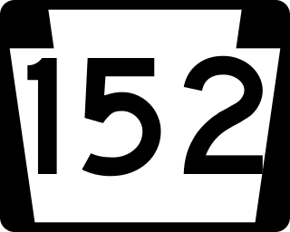
Pennsylvania Route 152 (PA 152) is a 25.3-mile-long (40.7 km) state highway located in the U.S. state of Pennsylvania. The route travels north–south from an interchange with PA 309 located in the Cedarbrook neighborhood of Cheltenham Township in Montgomery County north to another interchange with PA 309 located northeast of Telford in Bucks County. PA 152 is known as Limekiln Pike for most of its length. From the southern terminus, the route passes through suburban areas to the north of Philadelphia, serving Dresher, Maple Glen, and Chalfont. North of Chalfont, PA 152 runs through rural suburbs of Philadelphia before reaching Silverdale. Past here, the road continues northwest through Perkasie, where it turns southwest and passes through Sellersville before reaching its northern terminus.

U.S. Route 13 is a U.S. highway running from Fayetteville, North Carolina, north to Morrisville, Pennsylvania. The route runs for 49.36 mi (79.44 km) through the Philadelphia metropolitan area in the U.S. state of Pennsylvania. The route enters the state from Delaware in Marcus Hook, Delaware County. It continues northeast through Delaware County, passing through the city of Chester before heading through suburban areas along Chester Pike to Darby. US 13 enters the city of Philadelphia on Baltimore Avenue and runs through West Philadelphia to University City, where it turns north along several city streets before heading east across the Schuylkill River along Girard Avenue. The route turns north and heads to North Philadelphia, where it runs northeast along Hunting Park Avenue. US 13 becomes concurrent with US 1 on Roosevelt Boulevard, continuing into Northeast Philadelphia. US 13 splits southeast on a one-way pair of streets before heading northeast out of the city on Frankford Avenue. The route continues into Bucks County as Bristol Pike, heading northeast to Bristol, where it turns into a divided highway. US 13 becomes a freeway in Tullytown and continues north to its terminus at US 1 in Falls Township, near Morrisville. US 13 roughly parallels Interstate 95 (I-95) through its course in Pennsylvania.

SEPTA's Trolley Route 6, also known as the Ogontz Avenue Line is a former streetcar line and current bus route, operated by the Southeastern Pennsylvania Transportation Authority (SEPTA) in Philadelphia, Pennsylvania, United States.

The first Philadelphia Koreatown is located around the Olney section of the city of Philadelphia, United States. Since the late 1980s, the Korean community has expanded northward, and it now straddles the border between North Philadelphia in Philadelphia proper and the northern suburb of Cheltenham, although many Korean-American businesses and organizations and some residents remain in Olney and adjoining neighborhoods. Upper Darby Township, bordering West Philadelphia, also has a large Korean-American population; meanwhile, a rapidly growing Korean population and commercial presence has emerged in suburban Cherry Hill, New Jersey since 2010, centered along Marlton Pike, attracted to the Cherry Hill Public Schools. Signage in Hangul is ubiquitous in some neighborhoods in these areas.
Cheltenham Avenue is a major east-west road in Southeastern Pennsylvania. It is served by many SEPTA bus routes, trolleys, regional rail, and subway. Cheltenham Avenue is designated an unsigned quadrant route numbered State Route 2035 in its western section. It also is a major borderline; it defines the border between Springfield and Cheltenham townships, and Cheltenham Township and the City of Philadelphia, with the latter also being the Montgomery County and Philadelphia County. A section of the road along the Philadelphia–Cheltenham border is part of Pennsylvania Route 309.

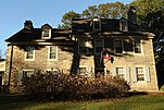
Cheltenham Township is a home rule township in Montgomery County, Pennsylvania. Cheltenham's population density ranges from over 10,000 per square mile in rowhouses and high-rise apartments along Cheltenham Avenue to historic neighborhoods in Wyncote and Elkins Park. It is the most densely populated township in Montgomery County. The population was 36,793 at the 2010 U.S. Census, making it the third most populous township in Montgomery County and the 27th most populous municipality in Pennsylvania. It was originally part of Philadelphia County, and it became part of Montgomery County upon that county's creation in 1784.