Chimaltenango Department

Last updated
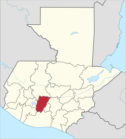
Chimaltenango Department
Departmento de Chimaltenango
Collage Chimaltenango Department.jpg
Counterclockwise from top: English: Mixco Viejo Ruins in San Martín Jilotepeque, Castle in Chimaltenango, Iximche Ruins in Tecpan, Madrean pine–oak woodlands in Chimaltenango, Acatenango volcano in Acatenango, Hacienda Real in Tecpan
Vlagchimaltenango.gif
Coat of arms of Chimaltenango Department.png
Chimaltenango in Guatemala.svg
Chimaltenango
Country Flag of Guatemala.svg Guatemala
Department Chimaltenango
Capital Chimaltenango
Municipalities 16
Government
  Type Departmental
Area
   Department of Guatemala 1,979 km2 (764 sq mi)
Population
 (2018) [1]
   Department of Guatemala 615,776
  Density310/km2 (810/sq mi)
   Urban
333,300
  Religions
Roman Catholicism Evangelicalism Maya
Time zone UTC-6

Chimaltenango is a department of Guatemala. The capital is Chimaltenango.

Contents

Geography

Located to the east are Guatemala Department, home to Guatemala City, and Sacatepéquez Department, while also bordered by Quiché Department and Baja Verapaz Department to the north, Escuintla Department and Suchitepéquez Department to the south, and Sololá Department to the west. The capital of Chimaltenango is located about 54 kilometers away from Guatemala City.

In addition to the city of Chimaltenango, the department contains the towns of Santa Apolonia (known for its ceramics), San Juan Comalapa, and Patzún (known for its elaborate Corpus Christi celebrations in June). Chimaltenango is also home to the Maya civilization ruins of Iximché and Mixco Viejo, in addition to many smaller sites.

Demographics

As of the 2018 census, the population of Chimaltenango department was 615,776. [1] The majority of the people in the department are of Cakchiquel Maya descent. The department has an area of 1,979 km².

There are several humanitarian aid groups that provide services in Chimaltenango.

Municipalities

  1. Acatenango
  2. Chimaltenango
  3. El Tejar
  4. Parramos
  5. Patzicía
  6. Patzún
  7. Pochuta
  8. San Andrés Itzapa
  9. San José Poaquil
  10. San Juan Comalapa
  11. San Martín Jilotepeque
  12. Santa Apolonia
  13. Santa Cruz Balanyá
  14. Tecpán Guatemala
  15. Yepocapa
  16. Zaragoza

The department abbreviation is CMT.

Related Research Articles

<span class="mw-page-title-main">Alta Verapaz Department</span> Department of Guatemala

<span class="mw-page-title-main">Quiché Department</span> Department of Guatemala

Quiché is a department of Guatemala. It is in the heartland of the Kʼicheʼ (Quiché) people, to the north-west of Guatemala City. The capital is Santa Cruz del Quiché. The word Kʼicheʼ comes from the language of the same name, which means "many trees".

<span class="mw-page-title-main">Guatemala Department</span> Department of Guatemala

Guatemala Department is one of the 22 departments of Guatemala. The capital is Guatemala City, which also serves as the national capital. The department consists of Guatemala City and several of its suburbs.

<span class="mw-page-title-main">Huehuetenango Department</span> Department of Guatemala

Huehuetenango is one of the 22 departments of Guatemala. It is located in the western highlands and shares the borders with the Mexican state of Chiapas in the north and west; with El Quiché in the east, with Totonicapán, Quetzaltenango and San Marcos in the south. The capital is the city of Huehuetenango.

<span class="mw-page-title-main">Retalhuleu Department</span> Department of Guatemala

Retalhuleu is a department located in the south-west of Guatemala, extending from the mountains to the Pacific Ocean coast. It has an area of 1856 km2. In 2018 the population of the Department of Retalhuleu was 326,828. Its capital, Retalhuleu City, mixes ancient and modern architecture, and it is also known for being a commercial city.

<span class="mw-page-title-main">Suchitepéquez Department</span> Department of Guatemala

Suchitepéquez is one of the 22 departments of Guatemala. Its capital is Mazatenango. It is situated in the southwestern region of Guatemala, bordering Quetzaltenango, Sololá, and Chimaltenango to the north, the Pacific Ocean to the south, Escuintla to the east, and Retalhuleu to the west.

<span class="mw-page-title-main">Kaqchikel people</span> Indigenous Maya people of Guatemala

The Kaqchikel are one of the indigenous Maya peoples of the midwestern highlands of Guatemala and of southern Mexico. They constitute Guatemala's third largest Maya group. The name was formerly spelled in various other ways, including Cakchiquel, Kakchiquel, Caqchikel, and Cachiquel.

<span class="mw-page-title-main">Jacaltenango</span> Municipality in Huehuetenango, Guatemala

Jacaltenango is a town and municipality situated in the Western Highlands of Guatemala. It is located in a valley surrounded by the Sierra Madre Mountains. Jacaltenango serves as the municipal seat for the surrounding municipality of the same name. In 2002, its urban population was about 23,500 but at the 2018 census the town's population has decreased to 22,533.

<span class="mw-page-title-main">San Pedro Soloma</span> Municipality in Huehuetenango, Guatemala

San Pedro Soloma is a town and municipality of Huehuetenango, a department of Guatemala. It is located in the Sierra de los Cuchumatanes at 2,300 m above sea level. The municipality covers a total area of 264 km2 with elevations ranging from 1,900 m to 3,500 m. Its population of 49,030 is spread over the town of Soloma, 19 villages and 50 smaller rural communities (caserios).

<span class="mw-page-title-main">Santiago Chimaltenango</span> Municipality in Huehuetenango, Guatemala

<span class="mw-page-title-main">San Juan Comalapa</span> Municipality and town in Chimaltenango, Guatemala

San Juan Comalapa is a town, with a population of 32,312, and a municipality in the Chimaltenango department of Guatemala.

<span class="mw-page-title-main">Patzún</span> Municipality in Chimaltenango, Guatemala

Patzún is a town, with a population of 26,632 and a municipality in the Chimaltenango department of Guatemala.

San Andrés Itzapa is a town, with a population of 24,992, and a municipality of Chimaltenango, Guatemala. San Andrés Itzapa is in the eastern region of Chimaltenango, while the district capital lies to the north, Acatenango lies to the south and to the east is Parramos. The municipality cover an area of 63.7 km2, with a total population of 32,083.

San Martín Jilotepeque is a town, with a population of 10,812, and a municipality in the Chimaltenango department of Guatemala. It was the site of a bus accident in 2013.

<span class="mw-page-title-main">Santa Apolonia, Chimaltenango</span> Municipality and town in Chimaltenango, Guatemala

Santa Apolonia is a municipality in the northern part of Chimaltenango department of Guatemala. Santa Apolonia is bordered by the towns of Tecpán to the west and south, San José Poaquil to the east and San Juan Comalapa to the southeast. The geographical extension of the town is 96 square kilometers (37 mi²).

<span class="mw-page-title-main">Tecpán Guatemala</span> Municipality and town in Chimaltenango, Guatemala

Tecpán is a town, with a population of 34,519, and a municipality in the department of Chimaltenango, in Guatemala, on the Inter-American Highway CA-1.

Yepocapa, also known as San Pedro Yepocapa, is a town with a population of 17,021, and a municipality in the Chimaltenango department of Guatemala. It is located at the base of Volcán de Fuego, which has destroyed the town several times, most recently on 14 October 1974.

Concepción Chiquirichapa is a municipality in the Guatemalan department of Quetzaltenango in the Western Highlands of Guatemala, 14 kilometers west of the departmental capital of Quetzaltenango, and 214 kilometers west of the capital Guatemala City. The municipality has a population of 17,342, 98% of whom identify as indigenous Maya-Mam and speak a dialect of Southern Mam.

<span class="mw-page-title-main">San Juan Ostuncalco</span> Municipality and town in Quetzaltenango, Guatemala

San Juan Ostuncalco, is a town, with a population of 20,763, and a municipality in the Quetzaltenango department of Guatemala. Beside Spanish, local people speak the Mam language.

<span class="mw-page-title-main">San Antonio Palopó</span> Municipality and village in Sololá, Guatemala

San Antonio Palopó is a municipality in the Sololá Department of Guatemala. The village is on the eastern shore of Lake Atitlán. The lowest elevation is 1,562 metres (5,125 ft) at the shoreline. The people of the region are Cakchiquel Maya with a distinctive style of clothing. The patron saint of the village is St. Anthony of Padua. The annual festival takes place on 13 June.

References

  1. 1 2 Citypopulation.de Population of departments in Guatemala

14°33′48″N90°58′55″W / 14.563316°N 90.982067°W / 14.563316; -90.982067