The East London line is part of the London Overground, running north to south through the East, Docklands and South areas of London. It was previously a line of the London Underground.

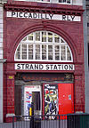
Aldwych is a closed station on the London Underground, located in the City of Westminster in Central London. It was opened in 1907 with the name Strand, after the street on which it is located. It was the terminus of the short Piccadilly line branch from Holborn that was a relic of the merger of two railway schemes. The station building is close to the Strand's junction with Surrey Street, near Aldwych. During its lifetime, the branch was the subject of a number of unrealised extension proposals that would have seen the tunnels through the station extended southwards, usually to Waterloo.

The Northern City Line is a commuter railway line in England, which runs from Moorgate station to Finsbury Park in London with services running beyond. It is part of the Great Northern Route services, and operates as the south-eastern branch of the East Coast Main Line (ECML). It is underground from Moorgate to Drayton Park in Highbury, from which point it runs in a cutting until joining the ECML south of Finsbury Park. Its stations span northern inner districts of Greater London southwards to the City of London, the UK's main financial centre. Since December 2015, its service timetable has been extended to run into the late evenings and at weekends, meeting a new franchise commitment for a minimum of six trains per hour until 23:59 on weekdays and four trains per hour at weekends.

Finsbury Park is an intermodal interchange station in North London for London Underground, National Rail and London Buses services. The station is the third busiest Underground station outside Zone 1, with over 33 million passengers using the station in 2019.

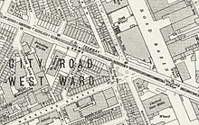
City Road or The City Road is a road that runs through central London. The northwestern extremity of the road is at Angel where it forms a continuation of Pentonville Road. Pentonville Road itself is the modern name for the eastern part of London's first bypass, the New Road from Paddington to Islington, which was constructed in 1756. The City Road was built in 1761 as a continuation of that route to the City of London.

Highbury & Islington is an interchange station in the London Borough of Islington, North London for London Underground, London Overground and National Rail services

Euston is a London Underground station. It directly connects with its National Rail railway station above it. The station is in Travelcard Zone 1.

Old Street is an interchange station at the junction of Old Street and City Road in Central London for London Underground and National Rail services.

Angel is a London Underground station in the Angel area of the London Borough of Islington. It is on the Bank branch of the Northern line, between King's Cross St. Pancras and Old Street stations, in Travelcard Zone 1. The station was originally built by the City & South London Railway (C&SLR) and opened on 17 November 1901. The station served as a terminus until the line was extended to Euston on 12 May 1907.

Farringdon is an interchange station located in Clerkenwell, London, England, in the London Borough of Islington, just outside the boundary of the City of London for London Underground, Elizabeth line and National Rail services.

St Paul's is a London Underground station located in the City of London financial district. The station, which takes its name from the nearby St Paul's Cathedral, is on the Central line, between Bank and Chancery Lane stations, and is in fare zone 1.

Barbican is a London Underground station situated near the Barbican Estate, on the edge of the ward of Farringdon Within, in the City of London in Central London. It has been known by various names since its opening in 1865, mostly in reference to the neighbouring ward of Aldersgate.

King William Street was the original but short-lived northern terminus of the City and South London Railway (C&SLR), the first successful deep-level underground railway in London and one of the component parts of the London Underground's Northern line. It was located in the City of London, on King William Street, just south of the present Monument station. When King William Street was in operation the next station to the south was Borough and the southern terminus of the line was Stockwell.

York Road is a disused station on the London Underground in Kings Cross, London, England, located between King's Cross and Caledonian Road, with its entrance at the corner of York Road and Bingfield Street.
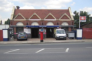
Drayton Park is a National Rail station in Highbury, in the London Borough of Islington. It is on the Northern City Line between Highbury & Islington and Finsbury Park stations, 2 miles 56 chains (4.3 km) down the line from Moorgate; it is in Travelcard Zone 2.

Essex Road is a National Rail station in Canonbury in Greater London, England, and is on the Northern City Line between Old Street and Highbury & Islington, 1 mile 59 chains (2.8 km) down the line from Moorgate, and is in Travelcard Zone 2. The station is at the junction of Essex Road, Canonbury Road and New North Road, with the present entrance on Canonbury Road. Operated by Great Northern, it is the only deep-level underground station in London served exclusively by National Rail trains. Between 1933 and 1975 the station was operated as part of the London Underground, as a short branch of the Northern line. Between 1922 and 1948 the station name was Canonbury & Essex Road. The name reverted to the original form in 1948.

The City and South London Railway (C&SLR) was the first successful deep-level underground "tube" railway in the world, and the first major railway to use electric traction. The railway was originally intended for cable-hauled trains, but owing to the bankruptcy of the cable contractor during construction, a system of electric traction using electric locomotives—an experimental technology at the time—was chosen instead.

Finsbury Pavement is a short length of street in England connecting Moorgate with City Road in the London Borough of Islington. It forms a part of the London Inner Ring Road, and before the introduction of the ring of steel around the City of London it formed a major through-route towards London Bridge and south London.

Stroud Green railway station is a former station in the Stroud Green area of north London. It was located between Finsbury Park station and Crouch End station on a bridge over Stapleton Hall Road. The station had platforms cantilevered from the bridge structure and a wooden station building at ground level under and on either side of the bridge, with a station master's house to the north of it. The bridge still exists and now carries the Parkland Walk cycle and pedestrian path, whilst the station master's house serves as a community centre.

The Angel is an area on the northern fringes of Central London within the London Borough of Islington. It is 2 miles (3.2 km) north-northeast of Charing Cross on the Inner Ring Road at a busy transport intersection. The area is identified in the London Plan as one of 35 major centres in London. It is a significant commercial and retail centre, and a business improvement district. The Angel straddles the ancient boundary of the parishes of Clerkenwell and Islington that later became the metropolitan boroughs of Finsbury and Islington. It is named from the former Angel Inn which stood on the corner of Islington High Street and Pentonville Road. Since 1965 the whole area has formed part of the London Borough of Islington in Greater London.