
Limehouse is a National Rail and connected Docklands Light Railway (DLR) station in Limehouse, London, England. It is served by regional services operated by c2c to and from Fenchurch Street, and by light metro services provided by the DLR to and from Tower Gateway or Bank. On the main line, Limehouse is located 1 mile 58 chains (2.8 km) from Fenchurch Street and the following station is West Ham; on the DLR it is between Shadwell and Westferry in Travelcard Zone 2.

Fenchurch Street railway station, also known as London Fenchurch Street, is a central London railway terminus in the southeastern corner of the City of London. It takes its name from its proximity to Fenchurch Street, a key thoroughfare in the City. The station and all trains are operated by c2c. Services run on lines built by the London and Blackwall Railway (L&BR) and the London, Tilbury and Southend Railway (LTSR) are to destinations in east London and south Essex, including Upminster, Grays, Basildon, Southend and Shoeburyness.

West Ham is a London Underground, Docklands Light Railway (DLR) and National Rail intermodal interchange station in West Ham, London, United Kingdom. The station is served by London Underground's District, Hammersmith & City and Jubilee lines, the Stratford International branch of the DLR, and c2c National Rail services.
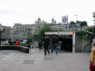
Tower Hill is a London Underground station in Tower Hill in the East End of London. It is on the Circle line between Monument and Aldgate stations, and the District line between Monument and Aldgate East. Tower Hill is within Travelcard zone 1 and is a short distance from Tower Gateway station for the Docklands Light Railway, Fenchurch Street station for National Rail mainline services, and Tower Millennium Pier for River Services.
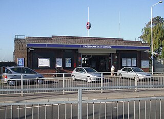
Dagenham East is a London Underground station located on the eastern side of the town of Dagenham in the London Borough of Barking and Dagenham, east London. It is on the District line between Dagenham Heathway to the west and Elm Park to the east. It is 6.4 kilometres (4.0 mi) along the line from the eastern terminus at Upminster and 27.8 kilometres (17.3 mi) to Earl's Court in central London where the line divides into numerous branches. The station has moderate usage for a suburban station, with approximately 3 million exits/entrances per year.
Stepney Green is a London Underground station located on Mile End Road in Stepney, London, United Kingdom. It is between Whitechapel and Mile End on the District line and the Hammersmith & City line, and is in Travelcard Zone 2.

Bow Road is a London Underground station located on Bow Road in Bow, London, England. It is on the District and Hammersmith & City lines. The station is interlinked as an out of station interchange (OSI) with Bow Church station on the Docklands Light Railway which is about 300 m (980 ft) away via Bow Road. The two stations are classed as a single station for ticketing purposes as well as on tube maps but both managed separately.
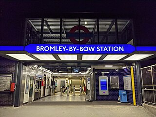
Bromley-by-Bow is a London Underground station located on the Blackwall Tunnel Northern Approach Road in the Bromley-by-Bow area of London, United Kingdom. The station is below the Blackwall Tunnel Northern Approach Road and lies between Bow Road and West Ham stations on the District and Hammersmith & City lines, and is in both Travelcard Zones 2 and 3.

Barking is an interchange station serving the town of Barking, east London. It is served by London Underground, London Overground and National Rail main line services. It is located on Station Parade, in the town centre.

Upton Park is a London Underground station on the District and Hammersmith and City lines, on Green Street in the Upton Park area of the London Borough of Newham, east London. It is in Zone 3.

Upminster is an interchange station serving the town of Upminster in the London Borough of Havering, Greater London. It is on the London, Tilbury and Southend line (LTSR), 15 miles 20 chains (24.5 km) down the line from London Fenchurch Street; it is the eastern terminus of the District line on the London Underground; and it is the eastern terminus of the Romford to Upminster Line on the London Overground network. Upminster is the easternmost station on the London Underground network as well as the easternmost National Rail station in London.

The London, Tilbury and Southend line, also known as Essex Thameside, is a commuter railway line on the British railway system. It connects Fenchurch Street station, in central London, with destinations in east London and Essex, including Barking, Upminster, Basildon, Grays, Tilbury, Southend and Shoeburyness.
Upminster Bridge is a London Underground station in the Upminster Bridge neighbourhood of Upminster in the London Borough of Havering, east London. It is on the District line between Hornchurch to the west and Upminster to the east. It is 1.2 kilometres (0.75 mi) along the line from the eastern terminus at Upminster and 33 kilometres (21 mi) to Earl's Court in central London where the line divides into numerous branches. The station was opened on 17 December 1934 by the London, Midland and Scottish Railway on the local electrified tracks between Upminster and Barking that were constructed in 1932. The main station building, on Upminster Road, is of a distinctive polygonal design by William Henry Hamlyn. It has relatively low usage for a suburban station, with approximately 1.15 million passenger entries/exits in 2017.

Elm Park is a London Underground station serving Elm Park in the London Borough of Havering, east London. It is on the District line between Dagenham East and Hornchurch. It is 4 kilometres (2.5 mi) along the line from the eastern terminus at Upminster and 30 kilometres (19 mi) to Earl's Court in central London where the line divides into numerous branches.

Hornchurch is a London Underground station serving the town of Hornchurch in the London Borough of Havering, east London. It is on the District line between Elm Park to the west and Upminster Bridge to the east. It is 2.5 kilometres (1.6 mi) along the line from the eastern terminus at Upminster and 31.7 kilometres (19.7 mi) to Earl's Court in central London where the line divides into numerous branches.
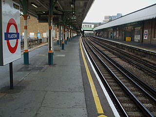
Plaistow is a London Underground station on Plaistow Road in the London Borough of Newham in Greater London. It is between West Ham and Upton Park stations on the District and Hammersmith & City lines, and in Travelcard Zone 3.

Becontree is a London Underground station located to the south of Becontree in the London Borough of Barking and Dagenham, east London. It is on the District line between Upney to the west and Dagenham Heathway to the east. It is 9.1 kilometres (5.7 mi) along the line from the eastern terminus at Upminster and 25.1 kilometres (15.6 mi) to Earl's Court in central London where the line divides into numerous branches. It is in Travelcard Zone 5.

Chafford Hundred Lakeside railway station, also known simply as Chafford Hundred station, is located on a single-track branch line of the London, Tilbury and Southend line, serving the area of Chafford Hundred as well as Lakeside Shopping Centre in Essex. It is 20 miles 77 chains (33.7 km) down the line from London Fenchurch Street via Upminster; it is situated between Ockendon and Grays. Its three-letter station code is CFH.
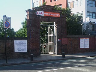
Woodgrange Park railway station is a railway station on Romford Road in Manor Park in the London Borough of Newham, east London. It is served by London Overground, and is on the Gospel Oak to Barking line, 12 miles 1 chain (19.3 km) down the line from Gospel Oak; it lies in Travelcard Zones 3 and 4. It has only limited station buildings and facilities.
The London, Tilbury and Southend Railway (LT&SR), was a British railway company, whose network connected Fenchurch Street station, in central London, with destinations in east London and Essex, including Barking, Upminster, Grays, Tilbury, Southend and Shoeburyness. The company and its assets were sold to the Midland Railway in 1912. The network over which they operated is largely intact and is currently operated as part of the Essex Thameside franchise.


