Edgware Road is a London Underground station on the Circle, District and Hammersmith & City lines, located on the corner of Chapel Street and Cabbell Street, within Travelcard zone 1. A separate station of the same name but served by the Bakerloo line is located about 150 metres away on the opposite side of Marylebone Road.

Rayners Lane is a London Underground station in the district of Rayners Lane in north west London, amid a 1930s development originally named Harrow Garden Village. The station is on the Uxbridge branch of both the Metropolitan line, between Eastcote and West Harrow stations, and the Piccadilly line, between Eastcote and South Harrow stations. The station is located to the west of the junction of Rayners Lane, Alexandra Avenue and Imperial Drive (A4090). It is in Travelcard Zone 5. Just east of the station, the Piccadilly and Metropolitan lines tracks join for services to Uxbridge and separate for those to Central London.

Yeovil Junction railway station is the busier, but less central, of two railway stations serving the town of Yeovil in England. The station is 2 miles (3.2 km) outside the town, in the village of Stoford. Although Yeovil is in Somerset, the station was in Dorset until 1991. It is 122 miles 48 chains (197.3 km) down the line from London Waterloo.

Barons Court is a London Underground station in West Kensington in the London Borough of Hammersmith and Fulham, Greater London. This station serves the District line and the Piccadilly line. Barons Court is between West Kensington and Hammersmith on the District line, and between Earl's Court and Hammersmith on the Piccadilly line and is in Travelcard Zone 2. East of the station, the Piccadilly line descends into tunnel towards Earl's Court and the District line continues in a cutting to West Kensington. The station is the last open air stop for eastbound trains on the Piccadilly line until Arnos Grove and has cross-platform interchange with the District line.

Ruislip is a London Underground station in Ruislip in west London. The station is on the Uxbridge branch of both the Metropolitan line and Piccadilly line, between Ruislip Manor and Ickenham stations. The station is located on Station Approach. It is in Travelcard Zone 6. It is the oldest station on the Uxbridge branch and was originally the only intermediate station on the line between Uxbridge and Harrow-on-the-Hill.

South Harrow is a London Underground station on the Uxbridge branch of the Piccadilly line. It is between Rayners Lane and Sudbury Hill stations. It is located on Northolt Road (A312). The station is in Travelcard Zone 5. There are several bus stands outside the station as well as overnight train stabling sidings.
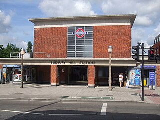
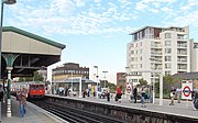
Sudbury Hill is a London Underground station on the Uxbridge branch of the Piccadilly line. The station is between Sudbury Town and South Harrow, and is in Travelcard Zone 4. It is located on Greenford Road (A4127) north of the junction with Whitton Avenue, on the border between the London Boroughs of Harrow and Ealing. The station is close to Sudbury Hill Harrow railway station.

Alperton is a London Underground station in Alperton, north-west London. It is on the Uxbridge branch of the Piccadilly line between Sudbury Town and Park Royal stations, in Travelcard Zone 4. It is located on Ealing Road (A4089), a short distance from the junction with Bridgewater Road (A4005), and is close to the Paddington branch of the Grand Union Canal.

Ealing Common is a London Underground station on the Uxbridge branch of the Piccadilly line and on the Ealing Broadway branch of the District line. Eastbound, the next station is Acton Town; westbound, the next station is North Ealing on the Piccadilly line and Ealing Broadway on the District line. Here, the District and Piccadilly lines share the same pair of tracks through the station – the only other example where a deep level line and a sub surface line share the same pair of tracks is further up the Uxbridge branch, where the Piccadilly line shares tracks with the Metropolitan line from Rayners Lane to Uxbridge. It is the only station west of Acton Town to be served by both the Piccadilly and District lines.

Putney Bridge is a London Underground station on the Wimbledon branch of the District line. It is between Parsons Green and East Putney stations and is in Zone 2. The station is located in the south of Fulham, adjacent to Fulham High Street and New Kings Road (A308) and is a short distance from the north end of Putney Bridge from which it takes its name.

Canonbury railway station serves the districts of Canonbury and Highbury within the London Borough of Islington in north London. It is on London Overground's North London line and East London line. The station and all trains serving it are operated by London Overground, and the station is in Travelcard Zone 2. This location of the station is close to the boundary with the London Borough of Hackney.

Raynes Park railway station serves the district of Raynes Park in the London Borough of Merton. It is 8 miles 51 chains (13.9 km) south-west of London Waterloo and is situated between Wimbledon and New Malden on the South West Main Line. The next station along on the Mole Valley branch line is Motspur Park.

Twickenham railway station is in Twickenham in the London Borough of Richmond upon Thames, England, and is in Travelcard Zone 5. By track it is 11 miles 22 chains (18.1 km) from London Waterloo. Only one main street abuts the station – at its west end – London Road running between a trunk road south of Twickenham Stadium and the town centre to the south including the town's public section of riverside.

Sudbury Town is a London Underground station on the Uxbridge branch of the Piccadilly line. The station is between Alperton and Sudbury Hill, and is in Travelcard Zone 4. It is located on the border between the London Boroughs of Brent and Ealing, with its main entrance on Station Approach in Sudbury. The forecourt of the station is known as Station Crescent. The station serves Sudbury, which forms the western part of Wembley.
North Ealing is a London Underground station on the Uxbridge branch of the Piccadilly line between Ealing Common and Park Royal. The station is located on Station Road, a short distance from the junction of Queen's Drive and Hanger Lane. It is in Travelcard Zone 3. West Acton station on the Central line is located about 550 metres to the east at the other end of Queen's Drive.

Wimbledon Park is a London Underground station in Wimbledon. The station is on the District line and is between Southfields and Wimbledon stations. The station is located on Arthur Road close to the junction with Melrose Avenue close to the eastern side of Wimbledon Park. It is about 200 metres (660 ft) west of Durnsford Road (A218) and is in Travelcard Zone 3.

Southfields is a London Underground station in Southfields in the London Borough of Wandsworth. The station is on the District line between East Putney and Wimbledon Park stations. The station is located on Wimbledon Park Road at the junction with Augustus Road and Replingham Road. It is in Travelcard Zone 3.

This article deals with the development of the London suburban railway lines of the London and South Western Railway (LSWR). For the wider view of the LSWR in general, see London and South Western Railway.
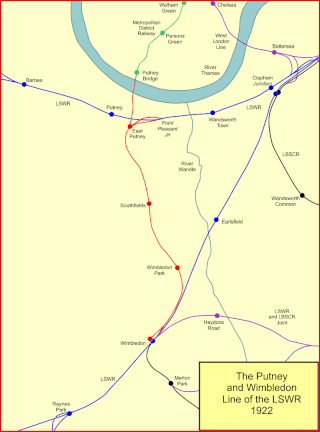
The Putney and Wimbledon line is a short railway route in south-west London. It was built by the London and South Western Railway as a collaborative arrangement with the Metropolitan District Railway. It was opened in 1889. The LSWR constructed Fulham Railway Bridge, although that was only ever used by District Railway trains. A spur connection from East Putney to the line from Barnes to Waterloo was used by LSWR trains.
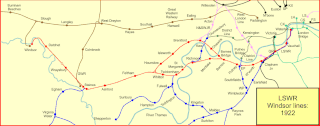
The Windsor lines of the London and South Western Railway ran from Waterloo to Windsor via Richmond, with a loop via Hounslow. They started as the Richmond Railway, a simple independent branch line, but they developed a distinct identity and had their own approach to Waterloo alongside the Main Lines, and a distinct section of Waterloo station. The Richmond Railway was extended to Windsor by the Windsor, Staines and South Western Railway; the company built a loop line via Hounslow in addition. Both independent companies were absorbed into the LSWR.