Eastcote House Gardens

Last updated

Eastcote House Gardens
Eastcote House Gardens Dovecote.jpg
The dovecote and herb beds
Greater London UK location map 2.svg
Red pog.svg
Location within Greater London
General information
Location Eastcote
Town or city Greater London
CountryEngland
Coordinates 51°35′12″N0°24′08″W / 51.586667°N 0.402222°W / 51.586667; -0.402222

Eastcote House Gardens is an area of public parkland in Eastcote, within the London Borough of Hillingdon. The site covers 3.63 hectares (9 acres) [1] and incorporates the walled garden, dovecote and coach house of Eastcote House. The house was demolished in 1964 by the then Ruislip-Northwood Urban District Council (RNUDC), one of the predecessors of the London Borough of Hillingdon which was formed the following year. At the public's request, the garden and outbuildings were retained and are now maintained by a group of volunteers, the Friends of Eastcote House Gardens, in partnership with the local authority.

Contents

Eastcote House was one of three largest in Eastcote, together with Highgrove House and Haydon Hall. [2] All came to be owned by the RNUDC, but only Highgrove House remains in its original form; Haydon Hall was demolished in 1967 by the RNUDC's successor. [3]

The coach house, dovecote, and garden walls received Grade II listed status on 6 September 1974. [4] Ecological surveys have found fifty types of trees in the gardens, and numerous species of birds, mammals and insects have been recorded. The gardens received the Green Flag Award in September 2011 following an earlier inspection.

History

Eastcote House

Eastcote House was the home of the Hawtrey family Eastcote House.jpg
Eastcote House was the home of the Hawtrey family

Eastcote House is first recorded in 1507, when it was known as "Hopkyttes", under the ownership of the Walleston family. [5] In 1525, Ralph Hawtrey married Winifred Walleston, and they made Hopkyttes their marital home, renaming it Eastcote House. The house was extended by either Ralph Hawtrey or his son John, and the brick exterior added. The original timber framework was not revealed again until the house was demolished. John Hawtrey built the dovecote without applying for the required licence. After his death in 1593, his nephew Ralph Hawtrey applied retrospectively, and the licence was granted. [6] During the 18th century, the dovecote was substantially rebuilt, leaving only the original first few rows of bricks. [7] The Hawtrey family, later the Hawtrey-Deanes, continued to live in the house until Francis Deane moved to East View in Uxbridge in 1878. Eastcote House was then let to tenants and parts of the estate sold for housing developments. [8]

The Ruislip-Northwood Urban District Council purchased the house and grounds, totalling 9.1 acres (3.7 ha), in 1931 after it became endangered by the proposed new housing development by the builders Comben & Wakeling. Eastcote House became a public building for the use of the Scouts, Guides, Women's Institute and a welfare clinic, though under the ownership of the council, the condition of the house deteriorated. In 1962 the house was declared unsafe, and it was demolished two years later after the council ruled there were no features of the house worth retaining. [7]

The Eastcote Billiards Club began using the coach house in 1938. The club's lease of the building expired in 2005, but the club remained in residence, rent-free. [9] In 2013, the club had moved to nearby Haydon Hall. [10]

Gardens

Detail of the entrance gate to the walled garden Eastcote House Gardens Gate.jpg
Detail of the entrance gate to the walled garden

The narrow bricks in the garden walls have been dated to around the 17th century. The walled garden would originally have been used predominantly for growing fruit, vegetables, and herbs for the household's consumption, as well as flowers to exhibit at shows and for pleasure. [11]

The walled garden, coach house, and dovecote were retained at the public's request when the house was demolished. [7] On 6 September 1974, the garden walls and remaining buildings were awarded Grade II listed status. [4] The herb garden was planted across the four centre beds in 1977 to celebrate the Silver Jubilee of Elizabeth II. These included Artemisia , catmint, Santolina and curry plants. To keep the plants within the beds, each was lined by box in 1983. [5]

The eastern wall was rebuilt in 1981, at which point the northern wall was reduced by seven layers of brick. An area of topiary with seven specimens was planted in 1983 with box, behind the coach house. Lilacs, weeping cherries and hibiscus were planted in 1984 along the garden wall near the coach house. A pergola covered with laburnum and wisteria was introduced in 1986 leading to the entrance into the walled garden. Between 1986 and 1988, two iron gates and a sundial were added. In the 1990s, the orchard near the walled garden was supplemented by black mulberry, walnut and quince trees. [5]

The coach house Eastcote House - geograph.org.uk - 1344726.jpg
The coach house

A footbridge crossing the River Pinn and leading to Long Meadow was replaced in 2007; the original had been built in 1977. [5] In 2008, the Friends of Eastcote House Gardens was formed to care for the gardens and ensure they remain protected. [5] The group received a £24,000 grant from the Big Lottery Fund for the replanting of the gardens, which went ahead in April 2010. [12] The Mayor of Hillingdon officially reopened the gardens on 17 July 2010. [12]

A survey completed in November 2009 found 50 types of trees in the gardens. Bats were found in the coach house during an ecological survey, but were not believed to be roosting there long-term. Species of birds observed in the gardens have included song thrush, jay, wren, robin, kingfisher and tawny owl. Mammals regularly observed include hedgehogs, grey squirrels and foxes. Butterflies including the holly blue and painted lady have been recorded. [5]

Hillingdon Council provided a £150,000 grant in September 2010 for the restoration of the buildings. [13] In April 2011, the council joined with the Friends to seek funding of up to £1 million from the Heritage Lottery Fund, to support restoration work. [14] It is planned that the coach house could be converted into a tea room. [15]

The gardens received the Green Flag Award in 2011 following an earlier inspection. The flag was raised in a ceremony on 14 September 2011. [16]

Related Research Articles

Ickenham Human settlement in England

Ickenham is an area in Greater London, forming the eastern part of Uxbridge and within the London Borough of Hillingdon.

Northwood, London Area of northwest London

Northwood is an area in northwest London, England. It is located within the London Borough of Hillingdon on the border with Hertfordshire and 14.5 miles (23.3 km) from Charing Cross. Northwood was part of the ancient parish of Ruislip, Middlesex and has formed part of Greater London since 1965.

Ruislip Area of west London

Ruislip is an area in the London Borough of Hillingdon in West London, and in the historic county of Middlesex. Ruislip lies 13.8 miles (22.2 km) west-north-west of Charing Cross, London.

London Borough of Hillingdon London borough in United Kingdom

The London Borough of Hillingdon is a large borough in West London, England. It was formed from the districts of Hayes and Harlington, Ruislip-Northwood, Uxbridge, and Yiewsley and West Drayton in the ceremonial county of Middlesex. Today, Hillingdon is home to Heathrow Airport and Brunel University, and is the second largest of the 32 London boroughs by area.

South Ruislip Human settlement in England

South Ruislip is an area of west London in the London Borough of Hillingdon, south-east of Ruislip, south of Eastcote, north-west of Northolt, and west of South Harrow. A 2017 estimation put the population of South Ruislip ward as 13,150 residents.

Eastcote Area of northwest London

Eastcote is an area in the London Borough of Hillingdon. It is in northwest London and the historic county of Middlesex.

Ruislip-Northwood (UK Parliament constituency) Parliamentary constituency in the United Kingdom, 1950–2010

Ruislip-Northwood was a borough constituency represented in the House of Commons of the UK Parliament from 1950 to 2010 that elected one member (MP) by the first past the post system of election. It was centred on the districts of Ruislip and Northwood in the London Borough of Hillingdon.

Ruislip-Northwood Urban District Former urban district in Middlesex, UK

Ruislip-Northwood was an urban district in west Middlesex, England, from 1904 to 1965. From its inception Ruislip-Northwood fell within the Metropolitan Police District and from 1933 it was part of the London Passenger Transport Area.

Ruislip Manor Human settlement in England

Ruislip Manor is an area of Ruislip in the London Borough of Hillingdon in West London. It is located approximately 13 miles (20.9 km) west north west of Charing Cross.

Ruislip Lido

Ruislip Lido is a reservoir and artificial beach in Ruislip, within the London Borough of Hillingdon, England, situated between Ruislip Common, Ruislip Woods, and Poor's Field.

Mount Vernon Hospital Hospital in England

Mount Vernon Hospital is located in Northwood, an area of north-west Greater London. It is one of two hospitals run by The Hillingdon Hospitals NHS Foundation Trust.

Project MoDEL

Project MoDEL is a project run for the Ministry of Defence (MoD) by the ministry's Defence Infrastructure Organisation and VSM Estates, a joint venture established between Vinci PLC and St. Modwen Properties to bid for the contract. The project involves the consolidation and sale of surplus Ministry of Defence properties around Greater London into around £180m of new developments at RAF Northolt. A total of 80% of the existing buildings at RAF Northolt were demolished and replaced by the newly built facilities.

RAF South Ruislip Non-flying Air Force station

RAF South Ruislip, also known as South Ruislip Air Station, was a non-flying Air Force station located in South Ruislip near London, England. Located close to RAF Northolt, the station was used by the United States Air Force's Third Air Force from 1949 until 1972, when the headquarters were moved to RAF Mildenhall.

Ruislip Woods Woodland in Ruislip, London

Ruislip Woods is a Site of Special Scientific Interest and national nature reserve covering 726 acres (294 ha) in Ruislip in the London Borough of Hillingdon. The woods became London's first national nature reserve in May 1997. Ruislip Local Nature Reserve at TQ 090 899 is part of the national nature reserve.

RAF Eastcote Former Royal Air Force site in London

RAF Eastcote, also known over time as RAF Lime Grove, HMS Pembroke V and Outstation Eastcote, was a UK Ministry of Defence site in Eastcote, Middlesex.

Manor Farm, Ruislip Historic site in Greater London, England

Manor Farm is a 22-acre (8.9 ha) historic site in Ruislip, Greater London. It incorporates a medieval farm complex, with a main old barn dating from the 13th century and a farm house from the 16th. Nearby are the remains of a motte-and-bailey castle believed to date from shortly after the Norman conquest of England. Original groundwork on the site has been dated to the 9th century.

Highgrove House, Eastcote Country house in Eastcote, London

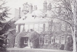
Highgrove House, also known as High Grove House or High Grove, is a Grade II listed mansion in the suburban area of Eastcote, within the London Borough of Hillingdon. Originally built in 1750 by the Reverend John Lidgould, the house was rebuilt in 1881 by Sir Hugh Hume-Campbell following a catastrophic fire. Along with Haydon Hall and Eastcote House, Highgrove was one of the three main houses of Eastcote and eventually became a residential hostel for homeless families, run by the local council from the 1960s until 2007. An area of the estate was sold to the local council in 1935 by the then-owner Eleanor Warrender to become what is now Warrender Park. In 1975, the house was granted Grade II listed status on account of its special architectural character.

Haydon Hall Building in Greater London, England

Haydon Hall was one of the three main houses of Eastcote, within what is now the London Borough of Hillingdon. The house was built in 1630 as a home for Lady Alice, Dowager Countess of Derby who had been living in Harefield. The house remained in the ownership of Lady Alice's descendants for several years, on the side of her eldest daughter. For a time the house was renamed "Eastcote Park" though was returned to the original name.

References

Citations

  1. "London Gardens Online Eastcote House Gardens". www.londongardensonline.org.uk. London Parks and Gardens Trust. Retrieved 21 September 2013.
  2. "Local History". Ruislip, Northwood and Eastcote Local History Society. 2010. Archived from the original on 1 December 2011. Retrieved 22 June 2011.
  3. Bowlt 1994, p.35
  4. 1 2 "Listed buildings" (PDF). London Borough of Hillingdon. Archived from the original (PDF) on 8 June 2011. Retrieved 17 June 2011.
  5. 1 2 3 4 5 6 "Eastcote House Gardens Management Plan 2010-2014" (PDF). London Borough of Hillingdon. Archived from the original (PDF) on 18 March 2012. Retrieved 17 June 2011.
  6. Bowlt 2007, p.39
  7. 1 2 3 Bowlt 1994, p.31
  8. Bowlt 1994, p.30
  9. "Meeting of the 72nd Annual General Meeting of the Eastcote Park Estate Association" (PDF). Eastcote Park Estate Association. 17 May 2010. Archived from the original (PDF) on 26 March 2012. Retrieved 22 June 2011.
  10. "Eastcote Billiards Club" Archived 2013-10-14 at the Wayback Machine in Eastcote Park Estate Association Newsletter, July 2013, p 4
    Eastcote Billiards Club website
  11. Ruislip, Northwood and Eastcote Local History Society 1984, p.11
  12. 1 2 "Friends of Eastcote House Gardens". Eastcote Local. Retrieved 22 June 2011.
  13. Cracknell, James (28 September 2010). "Eastcote House Gardens to benefit from £150,000 repairs grant". Uxbridge Gazette. Retrieved 22 June 2011.
  14. Cracknell, James (15 April 2011). "£1m appeal to restore Tudor estate". Uxbridge Gazette. Retrieved 17 June 2011.
  15. Cracknell, James (16 May 2012). "Summer of scones at Eastcote House Gardens". Uxbridge Gazette. Retrieved 17 May 2012.
  16. Cracknell, James (15 September 2011). "Hillingdon leading the way in Green Flag awards". Uxbridge Gazette. Archived from the original on 5 April 2012. Retrieved 26 September 2011.

Bibliography

Coordinates: 51°35′12″N0°24′8″W / 51.58667°N 0.40222°W / 51.58667; -0.40222