
The Berbice River, located in eastern Guyana, is one of the country's major rivers. It rises in the highlands of the Rupununi region and flows northward for 595 kilometres (370 mi) through dense forests to the coastal plain. The river's tidal limit is between 160 and 320 km (99–199 mi) from the sea.

Barima-Waini is a region of Guyana and is located in the northwest of the country. Barima-Waini has three sub-regions: Mabaruma, Matakai, and Moruca.
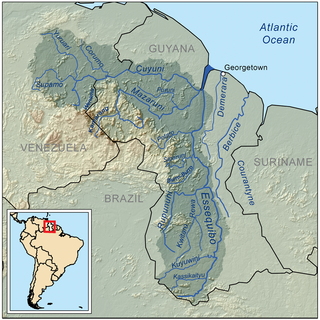
The Cuyuni River is a South American river and a tributary of the Essequibo River. It rises in the Guiana Highlands of Venezuela, where it descends northward to El Dorado, and turns eastward to meander through the tropical rain forests of the Cuyuni-Mazaruni Region of Guyana. It finally turns southeastward, flowing to its confluence with the Mazaruni River.
Trans Guyana Airways Limited is a Guyanese airline which commenced operations in 1956 in Georgetown, Guyana, with a single float airplane. Since then, the company has expanded their fleet to provide domestic and regional transportation, and to Guyana's remote areas.
Ituni is a village in the interior of Guyana, at an altitude of 100 metres (331 feet). The area grew as a result of bauxite mining in the area.

The Takutu River is a river in the Upper Takutu-Upper Essequibo Region of Guyana and Roraima in Brazil. It forms part of the boundary between the two countries. The confluence of the Takutu and Uraricoera Rivers forms the Branco River. The Takutu River's sources almost link with those of the Essequibo River; in the rainy season, flooding links the Takutu to the Rupununi River, a tributary of the Essequibo.
The Siparuni River is a river in the Potaro-Siparuni Region of Guyana. It is a tributary of the Essequibo River. Tributaries of the Siparuni River include the Takutu River, Burro-Burro River, Tipuru River and Levai Creek.
Kabakaburi is an Amerindian village in the Pomeroon-Supenaam Region of Guyana on the Pomeroon River, 56 km (35 mi) from its mouth. The village was founded in 1845 by William Henry Brett on the location where Fort Durban used to be.
The Mahaica River is a small river in northern Guyana that drains into the Atlantic Ocean. The village of Mahaica is found at its mouth.
The Barama River is a tributary of the Waini River, both being in the Barima-Waini administrative region of Guyana.
The Kako River is a river in the Cuyuni-Mazaruni region of Guyana and one of the largest tributaries of the Mazaruni River.
The Kuyuwini River is a river Guyana.
The New River is a river of South America located in the southeastern region of Guyana. It forms the Western border of the Tigri Area or New River Triangle, a disputed territory that is claimed by both Guyana and Suriname. In 1965, to bolster this territorial claim, the Surinamese government issued a decree to begin referring to the river as the Upper Corantyne River in Suriname.
The Eping River is a tributary of the Kamarang River in Region 8 of Guyana.
The Oko River is a river of Guyana, a tributary of the Wenamu River and a part of the middle-Mazaruni.
The Kuribrong River is a river of Guyana, a tributary of the Potaro River 2 miles north east of Potaro Landing.
Albion is a village in East Berbice-Corentyne, Guyana.
Mining in Guyana is a significant contributor to the economy owing to sizable reserves of bauxite, gold, and diamonds. Much of these resources are found in Guyana's Hilly Sand and Clay belt, a region that makes up 20% of the country.
Issano is a village of Cuyuni-Mazaruni, Guyana. It's located along the Mazaruni River, and is a hub for mining.
Isseneru is an Amerindian settlement in the Cuyuni-Mazaruni region of Guyana, approximately 15–20 miles west of Kurupung.
