Look up GPS in Wiktionary, the free dictionary.
GPS is the Global Positioning System, a satellite-based navigation system.
Contents
GPS may also refer to:
GPS is the Global Positioning System, a satellite-based navigation system.
GPS may also refer to:
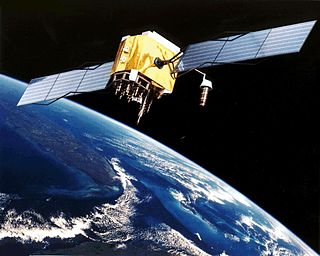
The Global Positioning System (GPS), originally Navstar GPS, is a satellite-based radio navigation system owned by the United States government and operated by the United States Space Force. It is one of the global navigation satellite systems (GNSS) that provide geolocation and time information to a GPS receiver anywhere on or near the Earth where there is an unobstructed line of sight to four or more GPS satellites. It does not require the user to transmit any data, and operates independently of any telephone or Internet reception, though these technologies can enhance the usefulness of the GPS positioning information. It provides critical positioning capabilities to military, civil, and commercial users around the world. Although the United States government created, controls and maintains the GPS system, it is freely accessible to anyone with a GPS receiver.
Galileo is a global navigation satellite system (GNSS) that went live in 2016, created by the European Union through the European Space Agency (ESA), operated by the European Union Agency for the Space Programme (EUSPA), headquartered in Prague, Czechia, with two ground operations centres in Fucino, Italy, and Oberpfaffenhofen, Germany. The €10 billion project is named after the Italian astronomer Galileo Galilei.
GLONASS is a Russian satellite navigation system operating as part of a radionavigation-satellite service. It provides an alternative to Global Positioning System (GPS) and is the second navigational system in operation with global coverage and of comparable precision.

Grosse Pointe Farms is a city in Wayne County in the U.S. state of Michigan. The population was 10,148 at the 2020 census.
Time and frequency transfer is a scheme where multiple sites share a precise reference time or frequency. The technique is commonly used for creating and distributing standard time scales such as International Atomic Time (TAI). Time transfer solves problems such as astronomical observatories correlating observed flashes or other phenomena with each other, as well as cell phone towers coordinating handoffs as a phone moves from one cell to another.

The World Geodetic System (WGS) is a standard used in cartography, geodesy, and satellite navigation including GPS. The current version, WGS 84, defines an Earth-centered, Earth-fixed coordinate system and a geodetic datum, and also describes the associated Earth Gravitational Model (EGM) and World Magnetic Model (WMM). The standard is published and maintained by the United States National Geospatial-Intelligence Agency.
The BeiDou Navigation Satellite System is a satellite-based radio navigation system owned and operated by the China National Space Administration. It is one of the global navigation satellite systems (GNSS) that provide geolocation and time information to a BDS receiver anywhere on or near the Earth where there is an unobstructed line of sight to four or more BDS satellites. It does not require the user to transmit any data, and operates independently of any telephonic or Internet reception, though these technologies can enhance the usefulness of the BDS positioning information.
A geodetic datum or geodetic system is a global datum reference or reference frame for precisely representing the position of locations on Earth or other planetary bodies by means of geodetic coordinates. Datums are crucial to any technology or technique based on spatial location, including geodesy, navigation, surveying, geographic information systems, remote sensing, and cartography. A horizontal datum is used to measure a location across the Earth's surface, in latitude and longitude or another coordinate system; a vertical datum is used to measure the elevation or depth relative to a standard origin, such as mean sea level (MSL). Since the rise of the global positioning system (GPS), the ellipsoid and datum WGS 84 it uses has supplanted most others in many applications. The WGS 84 is intended for global use, unlike most earlier datums.

A satellite navigation or satnav system is a system that uses satellites to provide autonomous geopositioning. A satellite navigation system with global coverage is termed global navigation satellite system (GNSS). As of 2023, five global systems are operational: the United States's Global Positioning System (GPS), Russia's Global Navigation Satellite System (GLONASS), India's Indian Regional Navigation Satellite System (IRNSS), China's BeiDou Navigation Satellite System (BDS), and the European Union's Galileo.

Differential Global Positioning Systems (DGPSs) supplement and enhance the positional data available from global navigation satellite systems (GNSSs). A DGPS for GPS can increase accuracy by about a thousandfold, from approximately 15 metres (49 ft) to 1–3 centimetres.
The Quasi-Zenith Satellite System (QZSS), also known as Michibiki (みちびき), is a four-satellite regional satellite navigation system and a satellite-based augmentation system developed by the Japanese government to enhance the United States-operated Global Positioning System (GPS) in the Asia-Oceania regions, with a focus on Japan. The goal of QZSS is to provide highly precise and stable positioning services in the Asia-Oceania region, compatible with GPS. Four-satellite QZSS services were available on a trial basis as of 12 January 2018, and officially started on 1 November 2018. A satellite navigation system independent of GPS is planned for 2023 with seven satellites. In May 2023 it was announced that the system would expand to eleven satellites.

The Timation satellites were conceived, developed, and launched by the United States Naval Research Laboratory in Washington, D.C. beginning in 1964. The concept of Timation was to broadcast an accurate time reference for use as a ranging signal to receivers on the ground. On 31 May 1967, the Timation-1 satellite was launched. This was followed by the Timation-2 satellite launch in 1969. The results of this program and Air Force Project 621B formed the basis for the Global Positioning System (GPS). The Navy's contribution to the GPS program continued to be focused on ever more accurate clocks.
GPS Block III consists of the first ten GPS III satellites, which will be used to keep the Navstar Global Positioning System operational. Lockheed Martin designed, developed and manufactured the GPS III Non-Flight Satellite Testbed (GNST) and all ten Block III satellites. The first satellite in the series was launched in December 2018.
The Indian Regional Navigation Satellite System (IRNSS), with an operational name of NavIC, is an autonomous regional satellite navigation system that provides accurate real-time positioning and timing services. It covers India and a region extending 1,500 km (930 mi) around it, with plans for further extension up to 3,000 km (1,900 mi). An extended service area lies between the primary service area and a rectangle area enclosed by the 30th parallel south to the 50th parallel north and the 30th meridian east to the 130th meridian east, 1,500–6,000 km (930–3,730 mi) beyond borders where some of the NavIC satellites are visible but the position is not always computable with assured accuracy. The system currently consists of a constellation of eight satellites, with two additional satellites on ground as stand-by.

GPS satellite blocks are the various production generations of the Global Positioning System (GPS) used for satellite navigation. The first satellite in the system, Navstar 1, was launched on 22 February 1978. The GPS satellite constellation is operated by the 2nd Space Operations Squadron (2SOPS) of Space Delta 8, United States Space Force.
The Grosse Pointe Public School System (GPPSS) is a school district headquartered in Grosse Pointe, Michigan in Metro Detroit.
The error analysis for the Global Positioning System is important for understanding how GPS works, and for knowing what magnitude of error should be expected. The GPS makes corrections for receiver clock errors and other effects but there are still residual errors which are not corrected. GPS receiver position is computed based on data received from the satellites. Errors depend on geometric dilution of precision and the sources listed in the table below.
Colonel Francis "Duke" Xavier Kane, Ph.D., USAF, retired, was the space planner and engineer responsible for the design concept of the Global Positioning System (GPS). Colonel Kane was General Bernard A. Schriever's Chief for Space and Ballistic Missile Planning at the U.S. Air Force Systems Command from 1961 to 1970. Colonel Kane was a participant in Project Forecast (1963–1964). Project Forecast was the longest-range technology forecast undertaken by the U.S. military prior to 1963. Project Forecast contemplated the strategic technological environment of 1975 and the requirements for U.S. advancements in air, space, missile, and computer technology.
USA-96, also known as GPS IIA-14, GPS II-23 and GPS SVN-34, is an American navigation satellite which is part of the Global Positioning System. It was 14 of 19 Block IIA GPS satellites to be launched, and the last one to be retired.
GPS Block IIIF, or GPS III Follow On (GPS IIIF), is the second set of GPS Block III satellites, consisting of up to 22 space vehicles. The United States Air Force began the GPS Block IIIF acquisition effort in 2016. On 14 September 2018, a manufacturing contract with options worth up to $7.2 billion was awarded to Lockheed Martin. The 22 satellites in Block IIIF are projected to start launching at the end of 2026, with launches estimated to last through at least 2034.