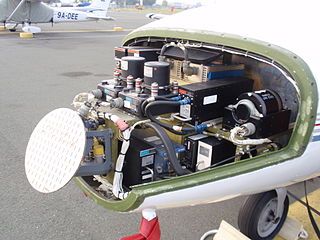
Avionics are the electronic systems used on aircraft. Avionic systems include communications, navigation, the display and management of multiple systems, and the hundreds of systems that are fitted to aircraft to perform individual functions. These can be as simple as a searchlight for a police helicopter or as complicated as the tactical system for an airborne early warning platform.

The Global Positioning System (GPS), originally Navstar GPS, is a satellite-based radio navigation system owned by the United States government and operated by the United States Space Force. It is one of the global navigation satellite systems (GNSS) that provide geolocation and time information to a GPS receiver anywhere on or near the Earth where there is an unobstructed line of sight to four or more GPS satellites. It does not require the user to transmit any data, and operates independently of any telephonic or Internet reception, though these technologies can enhance the usefulness of the GPS positioning information. It provides critical positioning capabilities to military, civil, and commercial users around the world. Although the United States government created, controls and maintains the GPS system, it is freely accessible to anyone with a GPS receiver.

An emergency position-indicating radiobeacon (EPIRB) is a type of emergency locator beacon for commercial and recreational boats, a portable, battery-powered radio transmitter used in emergencies to locate boaters in distress and in need of immediate rescue. In the event of an emergency, such as a ship sinking or medical emergency onboard, the transmitter is activated and begins transmitting a continuous 406 MHz distress radio signal, which is used by search-and-rescue teams to quickly locate the emergency and render aid. The signal is detected by satellites operated by an international consortium of rescue services, COSPAS-SARSAT, which can detect emergency beacons anywhere on Earth transmitting on the distress frequency of 406 MHz. The satellites calculate the position or utilize the GPS coordinates of the beacon and quickly passes the information to the appropriate local first responder organization, which performs the search and rescue. As Search and Rescue approach the search areas, they use Direction Finding (DF) equipment to locate the beacon using the 121.5 MHz homing signal, or in newer EPIRBs, the AIS location signal. The basic purpose of this system is to help rescuers find survivors within the so-called "golden day" during which the majority of survivors can usually be saved. The feature distinguishing a modern EPIRB, often called GPIRB, from other types of emergency beacon is that it contains a GPS receiver and broadcasts its position, usually accurate within 100 m (330 ft), to facilitate location. Previous emergency beacons without a GPS can only be localized to within 2 km (1.2 mi) by the COSPAS satellites and relied heavily upon the 121.5 MHz homing signal to pin-point the beacons location as they arrived on scene.
Garmin Ltd. is an American, Swiss-domiciled multinational technology company founded in 1989 by Gary Burrell and Min Kao in Lenexa, Kansas, United States, with headquarters in Olathe, Kansas. Since 2010, the company is legally incorporated in Schaffhausen, Switzerland.
Aeronautical Radio, Incorporated (ARINC), established in 1929, was a major provider of transport communications and systems engineering solutions for eight industries: aviation, airports, defense, government, healthcare, networks, security, and transportation. ARINC had installed computer data networks in police cars and railroad cars and also maintains the standards for line-replaceable units.
In the U.S., Federal Communications Commission (FCC) regulations prohibit the use of mobile phones aboard aircraft in flight. Contrary to popular misconception, the Federal Aviation Administration (FAA) does not actually prohibit the use of personal electronic devices on aircraft. Paragraph (b)(5) of 14 CFR 91.21 permits airlines to determine if devices can be used in flight, allowing use of "any other portable electronic device that the operator of the aircraft has determined will not cause interference with the navigation or communication system of the aircraft on which it is to be used."

The Garmin G1000 is an electronic flight instrument system (EFIS) typically composed of two display units, one serving as a primary flight display, and one as a multi-function display. Manufactured by Garmin Aviation, it serves as a replacement for most conventional flight instruments and avionics. Introduced in June 2004, the system has since become one of the most popular integrated glass cockpit solutions for general aviation and business aircraft.

In aviation, ACARS is a digital datalink system for transmission of short messages between aircraft and ground stations via airband radio or satellite. The protocol was designed by ARINC and deployed in 1978, using the Telex format. More ACARS radio stations were added subsequently by SITA.

The International Cospas-Sarsat Programme is a satellite-aided search and rescue (SAR) initiative. It is organized as a treaty-based, nonprofit, intergovernmental, humanitarian cooperative of 45 nations and agencies. It is dedicated to detecting and locating emergency locator radio beacons activated by persons, aircraft or vessels in distress, and forwarding this alert information to authorities that can take action for rescue. Member countries support the distribution of distress alerts using a constellation of around 65 satellites orbiting the Earth which carry transponders and signal processors capable of locating an emergency beacon anywhere on Earth transmitting on the Cospas-Sarsat frequency of 406 MHz.
A GPS tracking unit, geotracking unit, satellite tracking unit, or simply tracker is a navigation device normally on a vehicle, asset, person or animal that uses satellite navigation to determine its movement and determine its WGS84 UTM geographic position (geotracking) to determine its location. Satellite tracking devices may send special satellite signals that are processed by a receiver.
The Future Air Navigation System (FANS) is an avionics system which provides direct data link communication between the pilot and the air traffic controller. The communications include air traffic control clearances, pilot requests and position reporting. In the FANS-B equipped Airbus A320 family aircraft, an Air Traffic Services Unit (ATSU) and a VHF Data Link radio (VDR3) in the avionics rack and two data link control and display units (DCDUs) in the cockpit enable the flight crew to read and answer the controller–pilot data link communications (CPDLC) messages received from the ground.

In navigation, a radio beacon or radiobeacon is a kind of beacon, a device that marks a fixed location and allows direction-finding equipment to find relative bearing. But instead of employing visible light, radio beacons transmit electromagnetic radiation in the radio wave band. They are used for direction-finding systems on ships, aircraft and vehicles.
Global Navigation Satellite System (GNSS) receivers, using the GPS, GLONASS, Galileo or BeiDou system, are used in many applications. The first systems were developed in the 20th century, mainly to help military personnel find their way, but location awareness soon found many civilian applications.
The Capstone Program was a United States government-funded aviation safety program for the state of Alaska, primarily focusing on rural areas of the state. This joint effort – between the Federal Aviation Administration (FAA), the Alaska Pilot's Association, commercial operators, the University of Alaska, MITRE Corporation, some avionics manufacturers and individual pilots – cut the accident rate in the eastern part of Alaska by around 40%.

Radio is the technology of communicating using radio waves. Radio waves are electromagnetic waves of frequency between 3 hertz (Hz) and 300 gigahertz (GHz). They are generated by an electronic device called a transmitter connected to an antenna which radiates the waves. They are received by another antenna connected to a radio receiver. In addition to communication, radio is used for radar, radio navigation, remote control, remote sensing, and other applications.

Automatic Dependent Surveillance–Broadcast (ADS-B) is an aviation surveillance technology and form of Electronic Conspicuity in which an aircraft determines its position via satellite navigation or other sensors and periodically broadcasts its position and other related data, enabling it to be tracked. The information can be received by air traffic control ground-based or satellite-based receivers as a replacement for secondary surveillance radar (SSR). Unlike SSR, ADS-B does not require an interrogation signal from the ground or from other aircraft to activate its transmissions. ADS-B can also receive point-to-point by other nearby equipped "ADS-B In" equipped aircraft to provide traffic situational awareness and support self-separation. ADS-B is "automatic" in that it requires no pilot or external input to trigger its transmissions. It is "dependent" in that it depends on data from the aircraft's navigation system to provide the transmitted data.
Blue Sky Network is a global satellite technology company headquartered in San Diego, California. Founded in 2001, Blue Sky Network offers satellite tracking solutions to support fleet managers and operators monitoring their assets on land, sea, and in the air. Blue Sky Network solutions use the satellite network from Iridium Communications to provide customers with 100 percent global coverage. The company has also been an authorized Tier 1 Iridium Communications partner since 2002.

Flightradar24 is a Swedish Internet-based service that shows real-time aircraft flight tracking information on a map. It includes flight tracking information, origins and destinations, flight numbers, aircraft types, positions, altitudes, headings and speeds. It can also show time-lapse replays of previous tracks and historical flight data by airline, aircraft, aircraft type, area, or airport. It aggregates data from multiple sources, but, outside of the United States, mostly from crowdsourced information gathered by volunteers with ADS-B receivers and from satellite-based ADS-B receivers.
Aireon is an American company based in McLean, Virginia. Founded in 2011, it manufactures, deploys, and operates a global aircraft tracking and surveillance system utilizing satellite-based receivers to monitor the existing ADS-B transmissions of aircraft, for global air traffic surveillance.
Spidertracks is a New Zealand–based company specialising in the development of hardware and software for the general aviation industry. The company specialises in flight tracking, aviation communication, and flight data acquisition.