Gants Hill tube station

Last updated

Gants Hill Underground no-text.svg
Gants Hill stn southwest entrance.JPG
Southwest entrance in 2008
Greater London UK location map 2.svg
Red pog.svg
Gants Hill
Location of Gants Hill in Greater London
Location Gants Hill
Local authority London Borough of Redbridge
Managed by London Underground
Station codeGAH [1]
Number of platforms2
Fare zone 4
London Underground annual entry and exit
2018Decrease2.svg 6.49 million [2]
2019Decrease2.svg 6.36 million [3]
2020Decrease2.svg 3.74 million [4]
2021Decrease2.svg 2.84 million [5]
2022Increase2.svg 4.75 million [6]
Key dates
1942–1945Tunnels used by Plessey electronics as a munitions factory during the war [7]
14 December 1947Opened
Other information
External links
Coordinates 51°34′36″N0°03′58″E / 51.57666°N 0.06611°E / 51.57666; 0.06611
Underground sign at Westminster.jpg London transportportal

Gants Hill is a London Underground station in the largely residential Gants Hill district of Ilford in east London. It is served by the Central line and is between Redbridge and Newbury Park stations on the Hainault loop. It is in Travelcard Zone 4. It is the easternmost station to be below ground on the London Underground network [12] and the busiest on the Hainault loop. [3]

Contents

The station ticket hall is located beneath Gants Hill roundabout and reached via pedestrian subways. [13] It opened on 14 December 1947 as an extension of the Central line to form the new part of the Hainault loop. The station is known for its distinctive architecture featuring barrel-vaulted halls at platform level designed by Charles Holden.

Location

The station has taken its name from the Gants Hill roundabout, where the name Gants Hill could have originated from the le Gant family who were notable as stewards. [14] The ticket hall is directly underneath the roundabout, [15] located in the heart of Gants Hill district. The roundabout connects to Woodford Avenue, Eastern Avenue and Cranbrook Road. The station serves a mainly residential area, and is near Valentines Park, Valentines High School, and "Faces" Nightclub. [16]

History

As part of the 1935–40 New Works Programme, the Central line was to be extended from Liverpool Street to south of Leyton where it would connect to and take over passenger operations on the London & North Eastern Railway's (LNER's) suburban branch to Epping and Ongar in Essex. [17] [18] The section of the LNER's Fairlop Loop (now known as Hainault Loop) between Woodford and Newbury Park was also to be transferred, though not the section south from Newbury Park to Ilford and Seven Kings on the Great Eastern Main Line. [18] To replace the truncated route south from Newbury Park, a new underground section between Leytonstone and Newbury Park was constructed, running mostly under Eastern Avenue. Three new stations, which include Gants Hill were built to serve the new suburbs of north Ilford and the Fairlop Loop. [18] [note 1] During planning, the names "North Ilford" and "Cranbrook" were considered for this station. [17] [22]

Construction began before 1937 [15] and most of the tunnelled section was completed by 1940 but delayed due to the outbreak of the Second World War and eventually came to a halt in June 1940. During the war, the station was used as an air raid shelter and the unused tunnels between the station and Redbridge were used as a munitions factory for Plessey electronics. [7] [23] [note 2] Construction restarted after the war ended, [26] with the line extended to Stratford on 4 December 1946, and then to Leytonstone on 5 May 1947. Gants Hill station opened on 14 December 1947 as part of an extension to Newbury Park. [21] [27] [note 3]

Design

The lower concourse, with its design inspired by stations on the Moscow Metro Gants Hill stn interior concourse.JPG
The lower concourse, with its design inspired by stations on the Moscow Metro

The station, like the other two new stations on the branch, was designed by architect Charles Holden in the 1930s. During the 1930s the London Passenger Transport Board had provided advice on the construction of the Moscow Metro and an internal report in 1935 by the Underground's engineers on the Russian capital's system led to the decision to construct a station in London to a similar design. [29] [30] [note 4]

The station ticket hall is located beneath the roundabout at the centre of the road junction. [31] It is accessed via a series of pedestrian subways and has no street level buildings, although low structures on the roundabout sit above the ticket hall and provide daylight and ventilation. From the ticket hall, three escalators lead to the barrel-vaulted lower concourse between the two platforms tunnels. [32] [33] [34] The station also features miniature roundels on the tiles at platform level as well as the "roundel clocks". [35] [36] [37]

Gants Hill is the only Underground station with a concourse designed by Holden that has no surface buildings. [note 5] Unlike Redbridge, the station is not Grade II listed although its distinctive architectural qualities have gained public support for listing the station. [40]

Services and connections

Services

Gants Hill is served by the Central line between Redbridge and Newbury Park stations. [41] Train frequencies vary throughout the day, but generally operate every 3–4 minutes between 05:23 and 23:57 westbound and 06:25 and 01:03 eastbound. [42] [43]

Trains generally run between Hainault and Ealing Broadway via Newbury Park. The typical off-peak service, in trains per hour as of 2018 is: [42] [43]

The typical Night Tube service, in trains per hour as of 2018 is: [44]

Connections

A number of London Buses routes 66, 123, 128, 150, 167, 179, 296, 396, 462, SL2, and school routes 667, 677, 679; as well as a single night route N8 serve the station. [45]

Notes and references

Notes

  1. South of Newbury Park, the west-facing junction with the Great Eastern Main Line closed in 1948 to allow the expansion of Ilford carriage depot [19] [20] while Seven Kings Junction was closed in 1956. [20] [21]
  2. The factory opened in March 1942 which provided employment for 2,000 people; [7] production lasted until 1945. [24] The factory extended almost 5 miles with about 300,000 sq. ft. of space. [25]
  3. Leytonstone to Woodford (via South Woodford) opened on the same day, forming two branches in the eastern region of the Central line. [27] [28]
  4. Stations on the original section of the Moscow Metro opened in 1935 that have a similar design include Krasnye Vorota, Okhotny Ryad and Chistyye Prudy.
  5. All other station designs have at least a surface building, which include Sudbury Town on the Piccadilly Line and South Wimbledon on the Northern Line. [38] [39]

Related Research Articles

<span class="mw-page-title-main">Central line (London Underground)</span> London Underground line

The Central line is a London Underground line that runs through central London, from Epping, Essex, in the north-east to Ealing Broadway and West Ruislip in west London. Printed in red on the Tube map, the line serves 49 stations over 46 miles (74 km), making it the longest line on the Underground. It is one of only two lines on the Underground network to cross the Greater London boundary, the other being the Metropolitan line. One of London's deep-level railways, Central line trains are smaller than those on British main lines.

<span class="mw-page-title-main">Ilford</span> Human settlement in England

Ilford is a large town in east London, England, 9 miles (14 km) north-east of Charing Cross. Part of the London Borough of Redbridge, Ilford is within the ceremonial county of Greater London. It had a population of 168,168 in 2011, compared to 303,858 for the entire borough.

<span class="mw-page-title-main">London Borough of Redbridge</span> London borough in United Kingdom

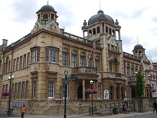
The London Borough of Redbridge is a London borough established in 1965.

<span class="mw-page-title-main">Bethnal Green tube station</span> London Underground station

Bethnal Green is a London Underground station in Bethnal Green, London, England, served by the Central line. It lies between Liverpool Street and Mile End stations, is in Travelcard Zone 2, and is open 24 hours on a Friday and Saturday as part of the Night Tube service. The station was opened as part of the long planned Central line eastern extension on 4 December 1946, having previously been used as an air-raid shelter. On 3 March 1943, 173 people, including 62 children, were killed in a crush while attempting to enter the shelter, in what is believed to be the largest loss of civilian life in the UK during the Second World War.

<span class="mw-page-title-main">Roding Valley tube station</span> London Underground station

Roding Valley is a London Underground station situated in Buckhurst Hill in the Epping Forest district of Essex, straddling the boundary between that council and Greater London. The station is on the Hainault loop of the Central line between Chigwell and Woodford stations. However, geographically it is midway between Woodford and Buckhurst Hill stations. It is located between Station Way and Cherry Tree Rise. Since 2 January 2007, the station has been in Travelcard Zone 4.

<span class="mw-page-title-main">Oxford Circus tube station</span> London Underground station

Oxford Circus is a London Underground station serving Oxford Circus at the junction of Regent Street and Oxford Street, with entrances on all four corners of the intersection. The station is an interchange between three lines: Bakerloo, Central and Victoria. As of 2022, it was the fourth-busiest station on the London Underground. On the Bakerloo line it is between Regent's Park and Piccadilly Circus stations, on the Central line it is between Bond Street and Tottenham Court Road stations, and on the Victoria line it is between Green Park and Warren Street stations. The station is in Travelcard Zone 1.

<span class="mw-page-title-main">Rayners Lane tube station</span> London Underground station

Rayners Lane is a London Underground station in the district of Rayners Lane in north west London, amid a 1930s development originally named Harrow Garden Village. The station is on the Uxbridge branch of both the Metropolitan line, between Eastcote and West Harrow stations, and the Piccadilly line, between Eastcote and South Harrow stations. The station is located to the west of the junction of Rayners Lane, Alexandra Avenue and Imperial Drive (A4090). It is in Travelcard Zone 5. Just east of the station, the Piccadilly and Metropolitan lines tracks join for services to Uxbridge and separate for those to Central London.

<span class="mw-page-title-main">Woodford tube station</span> London Underground station

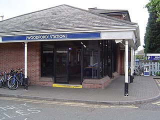
Woodford is a London Underground station in the town of Woodford in the London Borough of Redbridge, East London. The station is on the Central line, between South Woodford and Buckhurst Hill stations and is in Travelcard Zone 4. The station also acts as a terminus for services via the Hainault loop.

<span class="mw-page-title-main">Gants Hill</span> Human settlement in England

Gants Hill is an area of Ilford in East London, England, within the borough of Redbridge. It is a suburb 9.5 miles (15.3 km) east northeast of Charing Cross. It lends its name to a central roundabout where five roads meet.

<span class="mw-page-title-main">Grange Hill tube station</span> London Underground station

Grange Hill is a London Underground station on the Central line which lies in the parish of Chigwell in the Epping Forest district of Essex. The boundary with the London Borough of Redbridge is immediately to the east of the station buildings. The station is between Hainault and Chigwell stations. The station has been in Travelcard Zone 4 since 2 January 2007.

<span class="mw-page-title-main">East Acton tube station</span> London Underground station

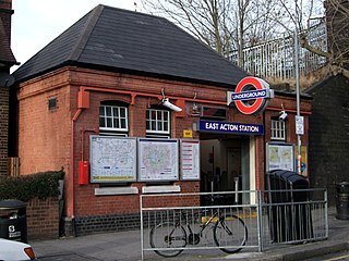
East Acton is a London Underground station in East Acton in London Borough of Hammersmith and Fulham. The station is on the Central line, between White City and North Acton stations, and in Travelcard Zone 2. Wormwood Scrubs, Queen Charlotte's and Chelsea Hospital, Hammersmith Hospital, Wormwood Scrubs prison and Imperial College Hammersmith branch are accessible from the station.

<span class="mw-page-title-main">Wanstead tube station</span> London Underground station

Wanstead is a London Underground station in Wanstead in the London Borough of Redbridge, east London. on the Hainault loop of the Central line. Towards Central London the next station is Leytonstone. Towards Woodford it is Redbridge. It is in Travelcard Zone 4. It opened on 14 December 1947 as an extension of the Central line to form the new part of the Hainault loop.

<span class="mw-page-title-main">Newbury Park tube station</span> London Underground station

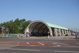
Newbury Park is a London Underground station in Newbury Park, Ilford, East London. It is between Barkingside and Gants Hill stations on the Hainault loop of the Central line, in Travelcard Zone 4. The station was initially opened by the Great Eastern Railway on 1 May 1903 and subsequently transferred its services to the London & North Eastern Railway due to the amalgamation. Underground trains only started serving the station on 14 December 1947, operating via the Gants Hill tunnel. The line was extended to Hainault on 31 May 1948. The Grade II listed bus shelter designed by Oliver Hill opened on 6 July 1949. Lifts were fully installed at Newbury Park in November 2018 to provide step-free access to the station, approximately 10 years after TfL abandoned the project.

<span class="mw-page-title-main">Redbridge tube station</span> London Underground station

Redbridge is a London Underground station on Eastern Avenue in the Redbridge district of Ilford in North East London, on the Hainault Loop of the Central line, in Zone 4. It opened on 14 December 1947 as an extension of the Central line to form the new part of the Hainault loop.

<span class="mw-page-title-main">Barkingside tube station</span> London Underground station

Barkingside is a London Underground station on the Central line. It is on the eastern edge of Barkingside in east London at the end of a cul-de-sac off Station Road. The station is next door to the home of Redbridge F.C. It is between Newbury Park and Fairlop stations and has been in Travelcard Zone 4 since 2 January 2007.

<span class="mw-page-title-main">Hainault tube station</span> London Underground station

Hainault is a London Underground station in Hainault, northeast London, England. The station is on the Central line between Fairlop and Grange Hill stations. Since 2 January 2007, the station has been in Travelcard Zone 4. It is also home to one of the three Central line depots.

<span class="mw-page-title-main">Chigwell tube station</span> London Underground station

Chigwell is a London Underground station in the town of Chigwell in the Epping Forest district of Essex. It is located on the Hainault Loop of the Central line, between Grange Hill and Roding Valley stations.

<span class="mw-page-title-main">Barkingside</span> Area of Ilford in east London, England

Barkingside is an area in Ilford, in the London Borough of Redbridge. It includes the major road junction of Fullwell Cross which also gives its name to the locality near that roundabout. The area is situated 10.6 miles (17km) north east of Charing Cross. Prior to 1965, it formed part of the borough of Ilford in the historic county of Essex.

The Hainault Loop, originally opened as the Fairlop Loop, is a 6.5-mile (10.5 km) branch line of the Great Eastern Railway (GER). It once connected Woodford on the Ongar branch to Ilford on the Main Line, with an eastward connection for goods, excursions and stock transfers to Seven Kings. The loop opened to freight on 20 April 1903 and to passengers on 1 May 1903. In 1923, the GER was "grouped" into the London & North Eastern Railway (LNER), who provided passenger services until December 1947. After this date, the route was electrified for London Underground services from both the Woodford and Leytonstone directions, the link to Ilford closed, and today it forms the greater part of the Hainault Loop on the Central line, having been served by Tube trains since 1948.

<span class="mw-page-title-main">Hainault Depot</span> London Underground railway depot on the Central line

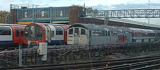
Hainault depot is a traction maintenance depot in Ilford on the London Underground Central line, between Hainault and Grange Hill stations, now in the London Borough of Redbridge, England. Until boundary changes in 1998, part of the depot was in Epping Forest District. Construction began in 1939, but was delayed by the onset of the Second World War, and was not completed until 1948. It has stabled three generations of trains, Standard stock, 1962 stock and 1992 stock. It has also housed trains of the experimental 1960 stock, both when it was conventionally controlled and during trials of Automatic Train Operation (ATO) in preparation for the construction of the Victoria line. Some of the 1967 stock destined for the Victoria line was also stabled at the depot while its ATO equipment was tested and commissioned on the Woodford to Hainault Branch.

References

  1. "Station Codes" (PDF). Transport for London. Retrieved 27 September 2021.
  2. "Station Usage Data" (CSV). Usage Statistics for London Stations, 2018. Transport for London. 23 September 2020. Archived from the original on 14 January 2023. Retrieved 11 October 2023.
  3. 1 2 "Station Usage Data" (XLSX). Usage Statistics for London Stations, 2019. Transport for London. 23 September 2020. Archived from the original on 9 November 2020. Retrieved 9 November 2020.
  4. "Station Usage Data" (XLSX). Usage Statistics for London Stations, 2020. Transport for London. 16 April 2021. Retrieved 1 January 2022.
  5. "Station Usage Data" (XLSX). Usage Statistics for London Stations, 2021. Transport for London. 12 July 2022. Retrieved 7 September 2022.
  6. "Station Usage Data" (XLSX). Usage Statistics for London Stations, 2022. Transport for London. 4 October 2023. Retrieved 10 October 2023.
  7. 1 2 3 Day & Reed 2010, p. 142.
  8. "Station Codes" (PDF). Transport for London. Retrieved 27 September 2021.
  9. "Station Codes" (PDF). Transport for London. Retrieved 27 September 2021.
  10. "Station Codes" (PDF). Transport for London. Retrieved 27 September 2021.
  11. "Station Codes" (PDF). Transport for London. Retrieved 27 September 2021.
  12. Tube Map with Tunnels (PDF) (Map). Transport for London. July 2017. Archived (PDF) from the original on 22 October 2018. Retrieved 22 October 2018.
  13. "Central Line". Railfanning London's Railways. City Transport Info. 31 December 2016. Archived from the original on 24 August 2017. Retrieved 24 August 2017.
  14. "Gants Hill – History". Speedprint Essex Ltd. Archived from the original on 22 October 2018. Retrieved 22 October 2018.
  15. 1 2 "Old Photos of Gants Hill". Speedprint Essex Ltd. Archived from the original on 22 October 2018. Retrieved 22 October 2018.
  16. "Gants Hill" (Map). Google Maps . Retrieved 22 October 2018.
  17. 1 2 North East London Electrification report upon the extension of the Central London line and train services. London Passenger Transport Board. 1935.
  18. 1 2 3 Day & Reed 2010, p. 116.
  19. Croome & Jackson 1993, p. 291.
  20. 1 2 Brennand 2006, p. IV.
  21. 1 2 Connor 2007, p. IV.
  22. Harris 2006, p. 29.
  23. Emmerson & Beard 2004, pp. 108–121.
  24. "Remembrance Sunday: The Secret Munitions Factory in the Underground tunnels at Gants Hill". Ilford Recorder. 10 November 2012. Archived from the original on 24 August 2017. Retrieved 24 August 2017.
  25. "Factory in an Uncompleted London Tube Tunnel". The Railway Magazine. Vol. 92, no. 563. Westminster: Railway Publishing Co. May–June 1946. p. 160.
  26. Croome & Jackson 1993, p. 288.
  27. 1 2 Croome & Jackson 1993, p. 287, 291.
  28. Feather, Clive (19 June 2017). "Central line". Clive's Underground Line Guides. Archived from the original on 24 August 2017. Retrieved 24 August 2017.
  29. Bruce, J Graeme; Croome, Desmond F (2006) [1996]. The Central Line: An Illustrated History (2nd ed.). Capital Transport. p. 56. ISBN   1-85414-297-6.
  30. Lawrence, David (1994). Underground Architecture. Harrow: Capital Transport. ISBN   1-85414-160-0.
  31. "Gants Hill" (Map). Google Maps. Retrieved 3 February 2018.
  32. Day & Reed 2010, p. 148.
  33. "3D Maps of Every Underground Station (CDEFG)". Transport for London, uploaded by IanVisits. 12 July 2015. Archived from the original on 3 February 2018. Retrieved 3 February 2018.
  34. "Tube Stations that Have No Surface Buildings". Tube Facts and Figures. Geofftech. Archived from the original on 2 August 2017. Retrieved 24 August 2017.
  35. "8. The Platform Clocks at Gants Hill". 150 Great Things About the Underground. 27 March 2012. Archived from the original on 22 October 2018. Retrieved 22 October 2018.
  36. "32. The Miniature Roundels at Gants Hill". 150 Great Things About the Underground. 3 July 2012. Archived from the original on 22 October 2018. Retrieved 22 October 2018.
  37. Marshall, Marshall (3 July 2013). "Londonist Ltd – Secrets of the Central Line". Youtube. Archived from the original on 22 October 2018.
  38. Historic England. "Sudbury Town Underground Station (1294594)". National Heritage List for England . Retrieved 12 November 2012.
  39. Historic England. "London Regional Transport Station, Including Adjacent Shops to Left and Right (1358037)". National Heritage List for England . Retrieved 14 February 2015.
  40. "From Russia to Redbridge: Moscow influenced Gants Hill Tube station 'worthy of being listed'". Ilford Recorder. 29 July 2015. Archived from the original on 16 January 2018. Retrieved 16 January 2018.
  41. Standard Tube Map (PDF) (Map). Not to scale. Transport for London. November 2022. Archived (PDF) from the original on 7 November 2022. Retrieved 12 November 2022.
  42. 1 2 "Central line timetable : From Gants Hill Underground station to Redbridge Underground station". Transport for London . Retrieved 5 February 2018.
  43. 1 2 "Central line timetable : From Gants Hill Underground station to Newbury Park Underground station". Transport for London . Retrieved 5 February 2018.
  44. "The Night Tube". Improving the Tube – What We're Doing. Transport for London. Archived from the original on 6 February 2018. Retrieved 6 February 2018.
  45. Buses from Gants Hill (PDF) (Map). Transport for London. April 2017. Archived (PDF) from the original on 13 May 2020. Retrieved 19 March 2023.

Books

Preceding station Underground no-text.svg London Underground Following station
Redbridge Central line Newbury Park
towards Hainault or Woodford