Gasabo District

Last updated
Gasabo District
GasaboDist.png
Shown within Kigali Province and Rwanda
Coordinates: 1°53′S30°08′E / 1.883°S 30.133°E / -1.883; 30.133
CountryFlag of Rwanda.svg  Rwanda
Province Kigali
Capital Gasabo
Sectors
List
  • Bumbogo
  • Gatsata
  • Gikomero
  • Gisozi
  • Jabana
  • Jali
  • Kacyiru
  • Kimihurura
  • Kimironko
  • Kinyinya
  • Ndera
  • Nduba
  • Remera
  • Rusororo
  • Rutunga
Government
  Mayor Pauline Umwali
Area
   District 430.30 km2 (166.14 sq mi)
Population
 (2022 census) [1] [2]
   District 879,505
  Rank 1st of 30 districts
  Density2,000/km2 (5,300/sq mi)
   Urban
[1]
712,399 (81%)
   Rural
[1]
167,106 (19%)
   Male
443,987 (50.48%)
   Female
435,518 (49.52%)
Website https://www.gasabo.gov.rw/

Gasabo is a district (akarere) in Kigali city, the capital of Rwanda. The headquarter of Gasabo is located in Remera Sector. The district also includes large areas of the city itself, including Kacyiru, Kimironko, Remera, Nyarutarama and Kimihurura.

Contents

The district is the location of the Gisozi Genocide Memorial Site, the burial place of approximately 300,000 victims of the 1994 Genocide against Tutsis. In addition to the cemetery, the memorial has a related genocide exhibition area and library and has plans to develop a teaching centre on the history of the genocide. [3]

Photographs of the 1994 Genocide against TUTSI Victims - Genocide Memorial Center - Kigali - Rwanda Photographs of Genocide Victims - Genocide Memorial Center - Kigali - Rwanda.jpg
Photographs of the 1994 Genocide against TUTSI Victims - Genocide Memorial Center - Kigali - Rwanda

History

Foreign Secretary William Hague and UNHCR Special Envoy Angelina Jolie visit the genocide memorial in Kigali, March 2013. The Foreign Secretary and Angelina Jolie visit The genocide memorial in Kigali (8595014576).jpg
Foreign Secretary William Hague and UNHCR Special Envoy Angelina Jolie visit the genocide memorial in Kigali, March 2013.

The original country of Rwanda, referred to as "the Rwanda of Gasabo" (u Rwanda rwa Gasabo), was a small territorial entity located in the present district of Gasabo, along the valley of Lake Muhazi, namely Nyabugogo. When the period of historical kings unfolded ("abami b’ibitekerezo"), Rwanda came under the reign of King Ruganzu Bwimba- The first king among series of historical kings who ruled from the fourteenth to the twentieth centuries. The kingdom of Rwanda was governed by kings (abami) [4]

During the Habyarimana government, the Gasabo District was called Gikomero commune. It was divided into ten sectors: Bumbogo, Gasabo, Gicaca, Gikomero, Gishaka, Kayanga, Nduba, Rutunga, Sha and Shango. [5]

Geography

The district occupies the northern half of Kigali province, which had its boundaries extended under local government reorganisation in 2006. Gasabo includes major suburbs of Kigali, sections of a ring of hills which surround the city, and some villages to the north and east of those. Rwanda's wealthiest area, Nyarutarama is also in the district, as are the office of the president (in Kacyiru) and most of the ministries.

The district contains the following sectors: Bumbogo, Gatsata, Gikomero, Gisozi, Jabana, Jali, Kacyiru, Kimihurura, Kimironko, Kinyinya, Ndera, Nduba, Remera, Rusororo, Rutunga. [6]

Population

Historical Population
of the Gasabo District
YearPopulation
Gasabo
Census of Population
and Housing
[1] [2]
2002Steady2.svg 320,516 2002 Rwandan Census
2012Increase2.svg 529,561 2012 Rwandan Census
2022Increase2.svg 879,505 2022 Rwandan Census

Basing to the results of the fourth population and housing census (2012) it indicated that Gasabo district has a population of 529,561 representing 46.8% among them male represent 51.7% and female 48.3% of the total population for Kigali City (1,132,686 population) and 5% of the total national population (10,515,973). This population is distributed into urban and rural area represented by 69% and 31% respectively. The average age of population is 25.5 years. According to EICV 5 (2017), 73.7% of  households headed by males and 22.1% of households headed by females in Gasabo district whereas at national level 68.6% of households headed by males and 25% of households headed by females. [7]

Sectors of the Gasabo District by
population according to the 2022 census
Sectors of
Gasabo District
Census
(2022)
[2]
Bumbogo112,899
Kinyinya125,400
Ndera95,164
Gisozi75,611
Nduba68,424
Jabana63,862
Rusororo61,787
Kimironko61,733
Gatsata46,262
10°Jali41,156
11°Remera38,648
12°Kacyiru30,036
13°Rutunga22,468
14°Gikomero19,630
15°Kimihurura16,425
TotalGasabo District879,505

Topography and climate

This district is characterized by the mixture of high mountains with average altitude of 1,800 metres (5,900 ft) mainly located in the rural zone, sloping basins and valleys. It has over 30 wetlands and small rivers traversing through the valleys. The main unique long river of about 50 km (31 mi) long and 1,000 metres (3,300 ft) wide is the one that originates from Lake Muhazi and traverses through marshy and boggy valleys before emptying into the Nyabugogo River and thereafter connects to the Nyabarongo River. Also, Lake Muhanzi in the north and part in the east borders Gasabo district.  Similarly, other water sources of importance are: Rusumo River in Rugende which ends in Akagera River, Buliza River that traverses through Karuruma, Umulindi and Rusine centers before empting into Nyabugogo River. These marshlands or wetlands provide potentialities to the district if well reclaimed can enhance or increase agriculture productivity, improve tourism, improve environmental ecological system as well. [8]

It has two main climatic seasons in a year, which are, the dry and rain seasons. The two major climatic seasons alternate within the year, hence, the District experiencing two dry seasons and rain seasons as defined below. [8]

Administratives boundaries

Kigali Genocide Memorial Centre - Flickr - Dave Proffer (1) - cropped Kigali Genocide Memorial Centre - Flickr - Dave Proffer (1) - cropped.jpg
Kigali Genocide Memorial Centre - Flickr - Dave Proffer (1) - cropped

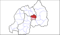
Gasabo is in the North East of Kigali City and bordered by Kicukiro district (south), Nyarugenge (west south), Rwamagana (east south), Rulindo (north west) and Gicumbi (north east). The district's surface area is 429.2 km2 (165.7 sq mi) of which a big portion is rural (84%) while the small portion represents the developed urban area (16%). [8]

Education

OLPC classroom teaching OLPC classroom teaching.JPG
OLPC classroom teaching

Education is the primary agent of transformation towards sustainable development. It increases people's capacities to transform their visions for society into reality. All countries strive for quality education for their sustainable development. In Africa, especially in our country Rwanda, education is considered as a fundamental human right and an essential means to ensure that all Rwandans realize their full potentials. It places special emphasis on basic education as a priority area within the Poverty Reduction Strategy Papers (PRSP) because of the strong correlation between education and improved economic opportunities, better life and fewer children (family planning), especially for girls. [Ministry of Finance and Economic Planning (MINECOFIN), 2005:40]. [9]

However, in Gasabo district- the indicators such as gross primary enrolment rate (139.9%) and gross secondary enrolment rate (66.1%) positions the district below the national rates of 148.4% (gross primary enrollment) and above the 40.9% national rate in gross secondary school enrolment. Also in terms of literacy levels- the district's literacy levels persons of 15 years and older in the district is above the national average rate of 69.7% at 84.8%, though, slightly below rates registered in Kicukiro and Nyarugenge at 89.5% and 86.7%. Though, the district level is below the country's target of 90% and 100%as stipulated in the 7YGP and Vision 2020 respectively. The same survey revealed that the computer literacy rate for persons of 15+ years stands at 17.4%. The district recognizes the need to improve the literacy rates to boost up ICT innovations and private sector led economy. According to the administrative data, the girl/boy attendance at primary level is equally balanced at 50% unlike the imbalance observed at high level

In terms of student/classroom ratio in primary level is at 35.9 below the standard of 46 pupils per classroom while pupil/qualified teacher ratio is 54. It is also observed that the district has unqualified, for example, in private, private aided and public primary schools are 5%, 4% and 8% respectively. Usage of computers and internet in primary schools is 4,641 computers and 28 schools have access to internet. [10]

Infrastructures located at Gasabo District

Gasabo District is set to upgrade and renovate the district infrastructure in line with the Kigali City Master Plan such as schools, Roads, King Faysal Hospital , Housing, Churches, Touristic zones, Memorial centers, Markets, Amahoro Stadium, Kigali Arena , Kigali Convention Center, different Ministries,...

Road in Kigali High Angle View Of Kigali City Street on November 29, 2018. Emmanuel Kwizera.jpg
Road in Kigali

Roads

This follows the signing of a memorandum of understanding between the district and Horizon Construction Company Ltd to facilitate the upgrading, construction and renovation of roads in the district [11]

Amahoro National Stadium

Amahoro Stadium is the biggest one in Rwanda and oldest. The ministry of sports plans to be able to host a large number of people. And Kigali ARENA the stadium that can host basketball, volleyball and shows have the capacity of 10,000 people seated.

Amahoro Stadium 2003 Amahoro Stadium 2003 c.png
Amahoro Stadium 2003

Notable persons

See also

Related Research Articles

<span class="mw-page-title-main">Kigali</span> Capital and the largest city of Rwanda

Kigali is the capital and largest city of Rwanda. It is near the nation's geographic centre in a region of rolling hills, with a series of valleys and ridges joined by steep slopes. As a primate city, Kigali is a relatively new city. It has been Rwanda's economic, cultural, and transport hub since it was founded as an administrative outpost in 1907, and became the capital of the country at independence in 1962, shifting focus away from Huye.

<span class="mw-page-title-main">Education in Rwanda</span> Overview of education in Rwanda

Education in Rwanda has undergone considerable changes throughout Rwanda's recent history, and has faced major disruptions due to periods of conflict. Education was divided by gender whereby women and men had a different education relevant to their responsibilities in day-to-day life. Women were mostly taught housekeeping while men were mainly taught how to hunt, raise animals, and fish. This is because Rwanda was a community-based society where every member had a specific contribution to the overall development of the community. Older family members like grandparents usually took on the role of educators.

<span class="mw-page-title-main">Districts of Rwanda</span>

The five provinces of Rwanda are divided into 30 districts. Each district is in turn divided into sectors, which are in turn divided into cells, which are in turn divided into villages.

<span class="mw-page-title-main">Muhanga District</span> District in Rwanda

Muhanga is a district (akarere) in Rwanda. It is found in southern province and its administrative centre is located in the city of Muhanga.

<span class="mw-page-title-main">Kicukiro District</span> District in Rwanda

Kicukiro District is one of the three Districts which constitute the City of Kigali and is situated in the South-East of the City of Kigali. Is a district (akarere) located in Kigali Province, Rwanda. Kicukiro is home to a thriving market, a number of NGOs(Non-Government Organizations) and the Bralirwa Brewery. In addition, it is the headquarters for the Friends Church in Rwanda. Kicukiro District is also home to two major memorial sites associated with the Rwandan genocide. These are the Rebero Genocide Memorial Site where 14,400 victims are buried, and the Nyanza Genocide Memorial Site where 5,000 victims were killed after Belgian soldiers who were serving in the United Nations peacekeeping forces abandoned them.

<span class="mw-page-title-main">Nyarugenge District</span> District in Rwanda

Nyarugenge is a district (akarere) in Kigali Province, Rwanda. Its heart is the city centre of Kigali, and contains most of the city's businesses.

<span class="mw-page-title-main">Karongi District</span> District in Rwanda

Karongi is a district (akarere) in Western Province, Rwanda. The district's capital is Rubengera. However, it comprises Kibuye, provincial capital and a major Rwandan lakeside resort. It is one of the districts with the lowest population density of 380 inhabitants per square kilometre (980/sq mi) as of the 2022 census.

<span class="mw-page-title-main">Gatsibo District</span> District in Rwanda

Gatsibo is a district (akarere) in Eastern Province, Rwanda. Its capital is Kabarore. It lies in the sectors of Gatsibo and Kageyo. It’s at about 1 hour and 50 minutes drive from Kigali city.

<span class="mw-page-title-main">Lake Muhazi</span>

Lake Muhazi is a long thin shallow lake in the east of Rwanda. The bulk of the lake lies in the Eastern Province, with the western end forming the border between the Northern and Kigali Provinces. It is a flooded valley lake, lying predominantly in an east to west direction, but with numerous offshoots in a north to south direction, formerly the location of tributaries. The lake has a concrete dam at the western end, constructed in 1999 to replace an earth dam which had existed since time immemorial. The lake empties into the Nyabugogo River, which flows southwards to Kigali where it meets the Nyabarongo River, part of the upper Nile.

<span class="mw-page-title-main">I&M Bank Rwanda</span> Rwandan bank

I&M Bank Rwanda Plc., is a commercial bank in Rwanda that is licensed by the National Bank of Rwanda. It is the second largest bank in Rwanda.

Access Bank Rwanda is a commercial bank in Rwanda. It is one of the commercial banks licensed by the National Bank of Rwanda, the national banking regulator.

Compagnie Générale de Banque (Cogebanque), sometimes referred to as Cogebank, is a Rwandan commercial bank. It is one of the commercial banks in the Republic of Rwanda, licensed by National Bank of Rwanda, the national banking regulator.

<span class="mw-page-title-main">Guaranty Trust Bank (Rwanda)</span> Rwandan commercial bank

Guaranty Trust Bank (Rwanda) plc, commonly referred to as GTBank Rwanda, is one of the licensed commercial banks in the Republic of Rwanda. It has been part of Nigerian Guaranty Trust Bank since 2013.

Ngoma is one of the sectors of Rulindo District in the northern province of Rwanda. The sector office is built between Busizi and Kiboha. It is on the top hill going from Jali of Gasabo District in the City of Kigali to Mugote and Remera

Masaka Hospital, Rwanda, commonly known as Masaka Hospital, is a hospital in Rwanda. It is an urban, general hospital built between 2008 and 2011, with funding from the Government of China, as a gift to the Government of Rwanda.

Cathia Uwamahoro is a Rwandan cricketer who is well known for breaking a Guinness world record in 2017 for the longest cricket net session by a woman.

Lilian Mukobwanakawe is a Rwandese Paralympic volleyballer who as of 2019 serves as the captain of the Rwanda Women Sitting Volleyball team. She was captain of the 2015 and 2019 ParaVolley Africa Sitting Volleyball Championships winning teams.

The University Teaching Hospital of Kigali (CHUK) is a 519 beds teaching hospital located in Kigali City, Rwanda. Founded in 1918 by Belgian colonialists, CHUK is the first and the biggest healthcare institution in Rwanda. CHUK has played a role in rebuilding Rwanda's healthcare after the genocide against Tutsi of 1994.

Kimisagara is a sector (umurenge) in the Nyarugenge District of Kigali Province, Rwanda. It is located in the southwest part of the city of Kigali.

Muhima is a sector (umurenge) in the Kigali Province, Nyarugenge district, Rwanda. It is located in the west part of the city of Kigali.

References

  1. 1 2 3 4 "Population of Rwanda according to the population and housing censuses". citypopulation.de. 2022-08-01. Retrieved 2023-03-05.
  2. 1 2 3 National Institute of Statistics of Rwanda (2023-02-28). "5th Population and Housing Census : Main Indicators Report". statistics.gov.rw. Retrieved 2023-03-05.
  3. Gasabo (6 June 2021). "akarere ka Gasabo". Akarere ka gasabo.
  4. "nurc.giv.rw" (PDF). Archived from the original (PDF) on 2023-02-03.
  5. Prosecutor v André Rwamakuba, Case No. ICTR-98-44C-T, (September 20, 2006)
  6. "Akarere ka Gasabo" . Retrieved 22 February 2023.
  7. Apeadu, Nana (2019-09-18), "An Ignored Population: Female-Headed Households Among Refugees in Africa 1", Where Did All the Men Go?, Routledge, pp. 171–191, doi:10.4324/9780429267550-8, ISBN   978-0-429-26755-0 , retrieved 2020-10-09
  8. 1 2 3 "Kigali City".
  9. "Memoire Online - The nature of schools and academic performance of pupils in primary schools in Gasabo district Kigali City - Damien Nzabihimana". Memoire Online. Retrieved 2020-10-09.
  10. "Gasabo Gov" (PDF).
  11. "All Africa".
  12. "Eugene Mussolini Is First MP Elect". KT PRESS. 2018-09-02. Retrieved 2022-08-28.