Ggaba

Last updated
Ggaba
Location map Kampala.png
Red pog.svg
Ggaba
Map of Kampala showing the location of Ggaba.
Coordinates: 00°15′23″N32°38′10″E / 0.25639°N 32.63611°E / 0.25639; 32.63611
CountryFlag of Uganda.svg  Uganda
Region Central Uganda
District Kampala Capital City Authority
Division Makindye Division
Elevation
1,140 m (3,740 ft)
Time zone UTC+3 (EAT)

Ggaba is a neighborhood within the city of Kampala in the Central Region of Uganda. [1]

Contents

Location

Ggaba is located on the northern shores of Lake Victoria, at the southern tip of the city of Kampala. Fgaba is generally a low topography area, It is bordered by Murchison Bay in Lake Victoria to the south and east, the village of Kawuku to the northeast, Bbunga to the north, Buziga to the northwest and Munyonyo to the southwest. It lies in Makindye Division, one of the five administrative burroughs of the city. [2]

The road distance between Ggaba and Kampala's central business district is approximately 11 kilometres (7 mi). [1] [3] The coordinates of Ggaba are:0°15'23.0"N, 32°38'10.0"E (Latitude:0.256390; Longitude:32.636113). [4]

Overview

Ggaba can be divided into the following major areas: [2]

Lake shore

This is the southeastern part of Ggaba and includes: (1) A small beach (2) A landing dock for fishing boats [1] (3) A fish market (4) A shopping center (5) A commercial resort with a private beach (6) Several bars and night spots. [1]

Ggaba Water Works

This is located in the southwestern part of the area and contains: [2] (1) The pumping stations (I, II and III) of National Water and Sewerage Corporation (NWSC). [1] The intake pumps that supply water to Kampala, Kira Municipality and Mukono are located here. (2) The Main Water Treatment Plant of NWSC [1] (3) Houses for the blue-collar workers of NWSC (4) Ggaba Police Station.

Little girl taking care of her young sister in a slum. Power of a female.jpg
Little girl taking care of her young sister in a slum.

Educational community

This area is mainly located in the northern part of the neighborhood. [2] The institutions include: (1) The main campus of Kampala University (2) Ggaba National Seminary (Catholic) (3) Ggaba Teachers Training Institute (4) St. Denis Ssebugwawo Secondary School (5) The Bunga campus of St. Augustine International University (6) Bbunga Primary School (7) Bbunga Islamic School. [1]

Residential areas

Interspersed between the schools, universities and teaching institutions are the residential areas. [2] The areas in the southern and western parts of Ggaba are generally of low income housing while those further north and east are upscale because they offer a better view of the lake. [5]

Medical institutions

(1) Jacky Medical Centre, is located at the northern tip of Ggaba (2) Wentz Medical Centre, is located in the northeastern part of Ggaba, close to Kampala University. (3) Martyrs Family Clinic, is located in the southern part of Ggaba, close to the NWSC Staff Houses. [1] (4) Ggaba Community Health Centre, is located in the southern part of Ggaba, inside the low income residential area close to the NWSC Water Treatment Plant. [2]

Kansanga-Ggaba Road

In 2013 the Uganda Police informed the public that according to police's observation, about one in every ten vehicles travelling on that road at that time, was operated by a person who was under the influence of alcohol. [6]

See also

Related Research Articles

Kanungu is a town in the Western Region of Uganda. It is the location of the district headquarters for Kanungu District.

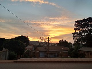
Lubowa is a location in Wakiso District of the Central Region of Uganda. It is a suburb of Kampala, the capital of Uganda and the largest city in that country.

<span class="mw-page-title-main">Makindye</span> Place in Central Uganda, Uganda

Makindye is a hill in Kampala, Uganda's largest city and capital. The name also refers to the neighborhood that sits on that hill. Makindye is also the seat of Makindye Division, one of the five administrative zones of the city of Kampala.

The National Water and Sewerage Corporation (NWSC) is a water supply and sanitation company in Uganda. It is wholly owned by the government of Uganda.

Muyenga is a hill in Kampala, the capital of Uganda and the largest city in that country. The name also applies to the upscale community that sits on that hill.

<span class="mw-page-title-main">Munyonyo</span> Place in Central Region of Uganda, Uganda

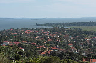
Munyonyo is an area on the northern shores of Lake Victoria and part of the metropolitan area of Kampala, in Makindye Division.

Makindye Division is one of the five administrative divisions of Kampala, the capital of Uganda, and the largest city in that country. The city's five divisions are: (a) Kampala Central Division (b) Kawempe Division (c) Lubaga Division (d) Makindye Division and (e) Nakawa Division.

Namuwongo is a location in Kampala, the capital of Uganda and the largest city in that country.

Kansanga is a neighborhood in Kampala, the capital and largest city of Uganda.

Kampala International University (KIU) is a private, not-for-profit institution based in Uganda. It was established in 2001 and assumed chartered status in 2009.

Naguru, also Naggulu, is a hill in Kampala, the capital and largest city in Uganda. The name also applies to the commercial and residential neighborhoods that sit on that hill.

Lweeza, also Lweza, is a neighborhood in the Buganda Region of Uganda. The correct phonetic spelling consistent with the local Ganda language is Lweeza.

<span class="mw-page-title-main">International University of East Africa</span> Private university in Uganda

International University of East Africa (IUEA) is a private for non-profit institution in Uganda, is a chartered University by the Uganda National Council for Higher Education (NCHE).

<span class="mw-page-title-main">Kabalagala</span> Place in Central Uganda, Uganda

Kabalagala is a neighbourhood in Kampala, the capital and largest city in Uganda. It houses some of the leading partygoers in the city. It is located next to Nsambya where the American Embassy in Uganda is found.

Munyonyo Commonwealth Resort is a luxurious Five star hotel-resort in Kampala, the capital and largest city in Uganda, the third-largest economy in the East African Community.

The Speke Resort and Conference Centre is a hotel-resort-conference-centre in Kampala, the capital and largest city of Uganda, the third-largest economy in the East African Community. It is one of the five 4-star hotels in Kampala, as rated by the Uganda Tourism Board in June 2015.

King Ceasor University is a private university previously known as St. Augustine International University.

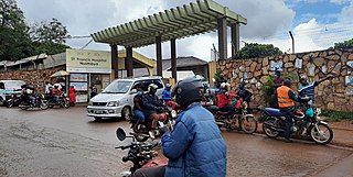
Kiruddu General Hospital, also known as Kiruddu General Referral Hospital, is a hospital in Uganda. It is an urban, public, general hospital. It cost an estimated US$10.3 million plus about $350,000 in supervisory fees to build. The hospital was constructed by the government of Uganda, with funding from the African Development Bank (AfDB) and the Nigeria Trust Fund (NTF). The hospital opened to the public on 16 May 2016.

Ssabagabo, also known as Makindye-Ssabagabo or Ssabagabo-Makindye, is a municipality in Uganda.

Katosi Water Works (KWW), also Katosi Water Treatment Plant is a water purification and distribution project in Uganda.

References

  1. 1 2 3 4 5 6 7 8 Ikwap, Emma (18 September 2013). "Know Your Hood: Ggaba; a fishing hub close to the city centre". Daily Monitor . Kmpala. Retrieved 28 October 2016.
  2. 1 2 3 4 5 6 Google (28 October 2016). "Map Showing the Boundaries of Ggaba, Makindye Division, Kampala" (Map). Google Maps . Google. Retrieved 28 October 2016.
  3. Globefeed.com (28 October 2016). "Distance between Uganda Post Office, Kampala Road, Kampala, Uganda and Ggaba Market, Kampala, Central Region, Uganda". Globefeed.com. Retrieved 28 October 2016.
  4. Google (28 October 2016). "The Geographical Coordinates of Ggaba, Makindye Division, Kampala, Uganda" (Map). Google Maps . Google. Retrieved 28 October 2016.
  5. Watuwa Timbiti, and Agnes Nantabi (30 April 2013). "Ggaba Suffocating Lake Victoria". New Vision . Kampala. Retrieved 13 June 2014.
  6. Sseguya, Josephat (14 February 2013). "Kansanga-Ggaba road has most drunkards, says Police". New Vision . Kampala. Retrieved 28 October 2016.

00°15′23″N32°38′10″E / 0.25639°N 32.63611°E / 0.25639; 32.63611