El Salvador is a country in Central America. Situated at the meeting point of three tectonic plates, it is highly seismologically active and the location of numerous earthquakes and volcanic eruptions. The country has a tropical climate.

El Salvador has transport links by road, rail, sea and air.

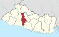
San Salvador is the capital and the largest city of El Salvador and its eponymous department. It is however the country's largest agglomeration. It is the country's political, cultural, educational and financial center. The Municipality of San Salvador has 525,990 inhabitants (2024). The Metropolitan Area of San Salvador, which comprises the capital itself and 13 of its municipalities, has a population of 2,404,097. The urban area of San Salvador has a population of 1,600,000 inhabitants.

Santiago Texacuangos is a municipality in the San Salvador department of El Salvador. It is near Lake Ilopango.
Tonacatepeque is a municipality in the San Salvador department of El Salvador. It has a population of 90,896 inhabitants according to the 2007 Census. This makes this municipality twelfth largest in terms of population in El Salvador. It is part of the San Salvador metropolitan area.
Soyapango is a municipality in the San Salvador department of El Salvador. Soyapango is the country's largest municipality with 284,700 residents. Soyapango is a satellite city of San Salvador and it is the main thoroughfare between San Salvador and the eastern part of the country, and nearly 70,000 vehicles travel through it every day. The nickname for this satellite city is Soya.

La Unión is a municipality in La Unión Department of El Salvador.
The Imperial Highway is a west-east thoroughfare in the counties of Los Angeles, Orange, Riverside, San Diego, and Imperial in the U.S. state of California. The main portion of the existing route begins at Vista Del Mar in Los Angeles near the Los Angeles International Airport and ends at the Anaheim–Orange city line at Via Escola where it becomes Cannon Street. Historically, the Imperial Highway extended from Vista Del Mar to Calexico, where a portion of the highway still exists. The original route was replaced with other highways, leading the older portions of the Imperial Highway to fall out of use.

Estadio Óscar Quiteño is a multi-purpose stadium in Santa Ana, El Salvador.

Lake Ilopango is a crater lake which fills an 8 by 11 km volcanic caldera in central El Salvador, on the borders of the San Salvador, La Paz, and Cuscatlán departments. The caldera, which contains the second largest lake in the country and is immediately east of the capital city, San Salvador, has a scalloped 100 m (330 ft) to 500 m (1,600 ft) high rim. Any surplus drains via the Jiboa River to the Pacific Ocean. The local military airbase, Ilopango International Airport, has annual airshows where international pilots from all over the world fly over San Salvador City and Ilopango lake.
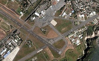
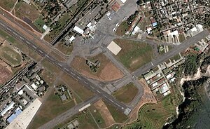
Ilopango International Airport is an airport located on the eastern part of the city of San Salvador, El Salvador, once serving the city as its international airport until 1980 when it was replaced by the larger and more modern El Salvador International Airport, located about 50 km south of the city. Currently, Ilopango is used for military, air taxi, and charter aviation only. It also holds the annual Ilopango Air Show. The airport is also home to the National Aviation Museum of San Salvador, which is housed in the old terminal building.

El Salvador International Airport Saint Óscar Arnulfo Romero y Galdámez, , previously known as Comalapa International Airport and as Comalapa Air Base to the military, is a joint-use civilian and military airport that serves San Salvador, El Salvador. It is located in the south central area of the country, in the city of San Luis Talpa, Department of La Paz, and occupies a triangular plain of 2,519.8 acres (1,019.7 ha), which borders the Pacific Ocean to the south, is bordered to the east by the Jiboa River, and to the northwest by the coastal highway. Being close to sea level, it allows aircraft to operate efficiently at maximum capacity. It is connected to the capital of San Salvador, El Salvador, through a modern four-lane motorway, with 42 kilometres (26 mi) travel in an average time of 30 minutes.

TACA Flight 390 was a scheduled flight on May 30, 2008, by TACA International from San Salvador, El Salvador, to Miami, Florida, United States, with intermediate stops at Tegucigalpa and San Pedro Sula in Honduras. The aircraft, an Airbus A320-233, overran the runway after landing at Tegucigalpa's Toncontín International Airport and rolled out into a street, crashing into an embankment and smashing several cars in the process.

The University of El Salvador or Universidad de El Salvador (UES) is the oldest and the most prominent university institution in El Salvador. It serves as the national university of the country. The main campus, Ciudad Universitaria, is located in the capital of San Salvador, but there are also branches of the university in other Salvadoran cities such as Santa Ana, San Miguel and San Vicente. The university counts a total of 9 faculties in its main campus and has a student population of more than 50,000.
The Civil Aviation Authority is the civil aviation agency of El Salvador. The agency conducts investigations into aviation accidents and incidents. The agency is headquartered in Ilopango Airport in Ilopango, San Salvador Department. Honduran authorities delegated the investigation of the TACA Flight 390 incident to the Salvadoran Civil Aviation Authority as per the Convention on International Civil Aviation.

Aviateca Flight 901 was a scheduled international passenger flight which crashed into the 7,159-foot (2,182 m) San Vicente volcano in El Salvador on approach to the Comalapa International Airport on 9 August 1995. The accident killed all 65 passengers and crew on board and is the deadliest aviation disaster to occur in El Salvador. An investigation by the Civil Aviation Authority determined that pilot error and air traffic control error in bad weather contributed to the accident.
La Cabaña Airport is an airstrip serving the town of La Cabaña. It is located in the municipality of El Paisnal in San Salvador Department, El Salvador.
The Battle of Ilopango Airport was a military engagement fought at the Ilopango International Airport in El Salvador in late January 1981. The battle was a part of the Salvadoran Civil War. It was fought between soldiers of the Salvadoran Air Force and guerrillas of the Farabundo Martí National Liberation Front.
The 1965 San Salvador earthquake occurred at 04:01 in the morning on May 3, 1965. It had a moment magnitude of 5.9 and a maximum Mercalli intensity of VIII (Severe). The shock caused severe damage to El Salvador's capital city, San Salvador. The town of Ilopango, Soyapango, and Delgado was also hard hit. The earthquake was the most destructive to affect the city prior to the 1986 earthquake.