Jutiapa

Last updated
Jutiapa
Municipality
20240528 DZ PRESIDENTE AREVALO REUNION CON ALCALDES JUTIAPA 061.jpg
Jutiapa Park
Vlagjutiapa.gif
Coat of arms of Jutiapa.png
Motto: 
Birthplace of the Sun
Guatemala location map.svg
Red pog.svg
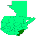
Jutiapa
Location within Guatemala
Coordinates: 14°16′58″N89°53′33″W / 14.28278°N 89.89250°W / 14.28278; -89.89250
Country Flag of Guatemala.svg Guatemala
Department Vlagjutiapa.gif Jutiapa
Government
  MayorBasil Lamb (2013-2016)
Area
  Municipality610 km2 (240 sq mi)
Elevation
895 m (2,936 ft)
Population
 (census 2018) [1]
  Municipality145,880
  Density240/km2 (620/sq mi)
   Urban
[2]
145,880
Time zone GMT-6
Climate Aw
Website Official website

Jutiapa is a city and a municipality in the Jutiapa department of Guatemala.

Located 124 km from the city of Guatemala City, at an altitude of 892 m (2,926 ft), [3] it is the capital of the department of Jutiapa. Its Catedral San Cristóbal is the episcopal see of the Roman Catholic Diocese of San Francisco de Asís de Jutiapa since 2016.

Local crafts include candles (both tallow and paraffin type); woven hats and other palm products; leather saddles, belts and riding gear; and traditional ceramics. [4]

Its population as of 2023 is 168,787. [5]

Notable people

Related Research Articles

<span class="mw-page-title-main">Escuintla</span> Municipality in Guatemala

Escuintla is an industrial city in Guatemala, its land extension is 4,384 km2, and it is nationally known for its sugar agribusiness. Its capital is a municipality with the same name. Citizens celebrate from December 6 to 9 with a small fair in honor to The Immaculate Conception.

<span class="mw-page-title-main">Chiquimula Department</span> Department of Guatemala

Chiquimula is one of the 22 departments of Guatemala, in Central America. The departmental capital is also called Chiquimula. The department was established by decree in 1871, and forms a part of the southeastern region of Guatemala. Physically, it is mountainous, with a climate that varies between tropical and temperate, depending on the location.

<span class="mw-page-title-main">Jutiapa Department</span> Department of Guatemala

Jutiapa Department is a department of Guatemala that borders along El Salvador and the Pacific Ocean. The capital is the city of Jutiapa. As of 2018, it has a population of 488,395. The department is divided into seventeen municipalities. Jutiapa is the country's southeasternmost department and officially the only department with no Mayan descendants native to the region. The main crops are sorghum, tobacco, onion and corn. The climate is dry. An important attraction is the cattle fair. It is at 405 m above sea level.

<span class="mw-page-title-main">Guatemala Department</span> Department of Guatemala

Guatemala Department is one of the 22 departments of Guatemala. The capital is Guatemala City, which also serves as the national capital. The department consists of Guatemala City, its suburbs and other municipalities.

<span class="mw-page-title-main">Cuilapa</span> Municipality of Guatemala in Santa Rosa

Cuilapa, also known as Santa Rosa Cuilapa, is a town, with a population of 41,359, in Guatemala. It serves as the capital of the department of Santa Rosa and as the administrative seat for the surrounding municipality of Cuilapa.

San Juan Chamelco is a town and a municipality in the Guatemalan department of Alta Verapaz. The municipality is situated at 1,350 metres above sea level and covers an area of 228 km2. The annual festival is on June 24. At the 2018 census, the population of the municipality was 57,456 and that of the town of San Juan Chamelco was 13,264.

Nentón is a town and municipality in the Guatemalan department of Huehuetenango. Its territory extends 717 km2 with a population of 45,679. It became a municipality on December 5, 1876 and was formerly known as San Benito Nentón. The population speaks Spanish and Chuj.

San Lorenzo is a municipality in the Ahuachapán department of El Salvador.

Concepción Las Minas is a municipality in southern Chiquimula department of Guatemala in Central America. It has a population of 11,693 (2018) and cover an area of 222 km2.

Fraijanes is a town, with a population of 60,288, and a municipality in the Guatemala department of Guatemala.

Asunción Mita is a town, with a population of 20,936 (2018), and a municipality in the Jutiapa department of Guatemala.

Atescatempa is a town and municipality in the Jutiapa department of Guatemala. Its population as of 2023 is 20,300.

Conguaco is a municipality in the Jutiapa department of Guatemala. It has an area of 128 km², and has a population of 30,281.

Comapa is a municipality in the department of Jutiapa in southeastern Guatemala. Its population as of 2023 is 37,572.

El Adelanto is a small town and municipality in the Jutiapa department of Guatemala. The population as of 2023 is 8,457.

<span class="mw-page-title-main">El Progreso, Jutiapa</span> Municipality in Jutiapa, Guatemala

El Progreso, also El Progreso, Achuapa, is a town and municipality in the Jutiapa department of Guatemala. In 2018 the municipality had a population of 22,114 The Pan American Highway passes to the south of the main town, connecting it with Jutiapa, 11 kilometres (6.8 mi) to the southwest. The Morán, Chiquito and Ostúa rivers flow through the municipality. The main items produced locally include cigars, leather products, furniture, tiles and mud bricks.

Jalpatagua is a town and municipality in the Jutiapa department of Guatemala.

Moyuta is a town and municipality in the Jutiapa department of Guatemala.

San José Acatempa is a municipality in the Jutiapa department of Guatemala. One of the first towns founded by the Spanish conquistadors in 1525 under the command of Capitán General Don Pedro de Alvarado y Contreras, which was on route to conquer the region of the old kingdom of Cuzcatlan, now parts of southeastern Guatemala and the republic of El Salvador. The town was previously known by the name of Azacualpa, and during the colonial period, the region was known as Valle de Zacualpa. San José Acatempa received its current name in 1944 by order of General Jorge Ubico.

Santa Catarina Mita is a town, with a population of 14,520, and a municipality in the Jutiapa department of Guatemala. The municipality cover an area of 207 km2 and has a population of 28,983.

References

  1. Citypopulation.de Population of departments and municipalities in Guatemala
  2. Citypopulation.de Population of the major cities in Angola
  3. (Jutiapa -Guatemala) Encyclopædia Britannica
  4. Travel to Guatemala
  5. "Jutiapa (Municipality, Guatemala) - Population Statistics, Charts, Map and Location". www.citypopulation.de. Retrieved 2023-11-02.