History
Early history
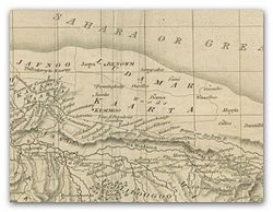
According to legend, Sounsan, the first capital of Kaarta was founded near Mourdiah around 1635 by Sunsana, son of Niangolo. His son Massa was famously productive both on the farm and in the bedroom, expanding his power and holdings by marrying his many daughters to men who would come fight for him and raiding his neighbors. In 1710 rule passed to his son Benefali (r. 1710-1745), who fought a long war against the rising power of Bitòn Coulibaly and the Segou Empire. Benefali's son Foulakoro (r. 1745-1754) besieged Mourdiah, whose inhabitants begged for aid from Coulibaly. He came to Kaarta with an army, defeated Foulakoro, and captured him. The faama of Kaarta soon died in captivity.
Re-Founding
Kaarta was re-established by Sey Bamana Coulibaly, who had fled Segou in 1754. Deniba Bo ruled from 1758-1761. Faama Sira Bo (r. 1761-1781) led a re-emergence of Kaarta as a regional power, establishing a permanent capital at Diangounté and vassalizing Diarra in 1777 and Khasso, as well as raiding Beledougou and Bambuk. [7] : 41 Sira Bo was succeeded by Desse Koro, who was defeated in battle by Mansong Diarra. Bodian Moriba (r.1818-1832) re-asserted the kingdom's power, made peace with Segou and moved the capital to Diangounté.
Fall to the Toucouleur
The kingdom was destroyed as an independent force in 1854 by El Hadj Umar Tall's jihad. He seized Nioro, and put the Faama Mamady Kandian and his entire family to death, ending the Massassi dynasty. After his death, his son Mokhtar Tall was made governor of the region. [9] He rebelled against his older brother Ahmadu Tall in 1869, but was ultimately defeated and imprisoned in 1873. [10] [11] He was replaced by Muntaga Tall. In 1885, encouraged by overtures from the French, Muntaga rebelled in turn, but was forced to commit suicide when Ahmadu besieged Nioro. [10]
French Conquest
In 1878 the French governor of Senegal Briere de l'Isle sent a French force against the Kaarta Toucouleur vassal state along the north bank of the Senegal River. Blocked by the colonial minister in Paris, he argued that they were a threat to the Senegalese Imamate of Futa Toro (then a French client state) with which the British were poised to interfere. The Ministry gave in and on 7 July 1878, a French force destroyed the Kaarta Toucouleur fort at Sabouciré, killing their leader, Almany Niamody. This portion of the Kaarta vassals was then incorporated into the Khasso protectorate kingdom. [12]
French Colonel Louis Archinard later conquered the entire territory of the former Kaarta kingdom in 1890, which was formally annexed into French West Africa in 1904.
This page is based on this
Wikipedia article Text is available under the
CC BY-SA 4.0 license; additional terms may apply.
Images, videos and audio are available under their respective licenses.