Klipheuvel | |
|---|---|
 Klipheuvel  Klipheuvel | |
| Coordinates: 24°36′32″S29°27′43″E / 24.609°S 29.462°E | |
| Country | South Africa |
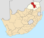
| Province | Limpopo |
| District | Capricorn |
| Municipality | Lepele-Nkumpi |
| Area | |
| • Total | 1.56 km2 (0.60 sq mi) |
| Population (2011) [1] | |
| • Total | 1,996 |
| • Density | 1,300/km2 (3,300/sq mi) |
| Racial makeup (2011) | |
| • Black African | 99.7% |
| • Coloured | 0.1% |
| • Indian/Asian | 0.2% |
| First languages (2011) | |
| • Northern Sotho | 84.9% |
| • S. Ndebele | 9.6% |
| • Tsonga | 2.7% |
| • Zulu | 1.1% |
| • Other | 1.8% |
| Time zone | UTC+2 (SAST) |
Klipheuvel is a town in Capricorn District Municipality in the Limpopo province of South Africa.