List of cities in Ivory Coast

Last updated

Map of Ivory Coast Cote d'Ivoire map.png
Map of Ivory Coast
Abidjan, economic capital of Cote d'Ivoire Transport lagunaire a Abidjan.jpg
Abidjan, economic capital of Côte d'Ivoire

This is a list of cities in Ivory Coast . Only the 40 most populous cities are listed here.

RankCoordinatesCity / townPopulation Regions
1975 census1988 census2005 Est2014 Est
1. 5°21′31″N4°00′50″W / 5.35861°N 4.01389°W / 5.35861; -4.01389 (Abidjan) Abidjan 951,2161,934,3423,692,5703,677,115 Lagunes
2. 7°41′N5°1′W / 7.683°N 5.017°W / 7.683; -5.017 (Bouaké) Bouaké 175,264332,999572,149567,481 Gbêkê
3. 6°53′N6°27′W / 6.883°N 6.450°W / 6.883; -6.450 (Daloa) Daloa 60,837122,933217,876319,427 Haut-Sassandra
4. 6°49′N5°17′W / 6.817°N 5.283°W / 6.817; -5.283 (Yamoussoukro) Yamoussoukro 37,253110,013200,659361,893 Bélier
5. 4°45′N6°38′W / 4.750°N 6.633°W / 4.750; -6.633 (San-Pédro) San-Pédro 31,60670,601195,873261,616 Bas-Sassandra
6. 5°50′N5°22′W / 5.833°N 5.367°W / 5.833; -5.367 (Divo) Divo 35,61072,494184,481184,481 Lôh-Djiboua
7. 9°25′N5°37′W / 9.417°N 5.617°W / 9.417; -5.617 (Korhogo) Korhogo 45,250109,655172,114286,071 Poro
8. 5°30′N4°3′W / 5.500°N 4.050°W / 5.500; -4.050 (Anyama) Anyama 26,40657,065158,250148,962 Lagunes
9. 6°44′N3°29′W / 6.733°N 3.483°W / 6.733; -3.483 (Abengourou) Abengourou 30,02858,974144,074135,635 Moyen-Comoé
10. 7°24′N7°33′W / 7.400°N 7.550°W / 7.400; -7.550 (MMan, Ivory Coast)) Man 50,28888,294140,217188,704 Tonkpi
11. 6°8′N5°56′W / 6.133°N 5.933°W / 6.133; -5.933 (Gagnoa) Gagnoa 42,28585,563125,647213,918 Gôh
12. 5°47′N6°36′W / 5.783°N 6.600°W / 5.783; -6.600 (Soubré) Soubré 7,01633,162123,214175,163 Nawa
13. 5°56′N4°13′W / 5.933°N 4.217°W / 5.933; -4.217 (Agboville) Agboville 26,91446,359108,68495,093 Agnéby-Tiassa
14. 5°19′N4°23′W / 5.317°N 4.383°W / 5.317; -4.383 (Dabou) Dabou 23,13439,49495,05788,430 Lagunes
15. 5°12′N3°44′W / 5.200°N 3.733°W / 5.200; -3.733 (Grand-Bassam) Grand-Bassam 27,27341,82590,81784,028 Sud-Comoé
16. 6°59′N5°45′W / 6.983°N 5.750°W / 6.983; -5.750 (Bouaflé) Bouaflé 17,18834,56289,344167,263 Marahoué
17. 6°29′N6°35′W / 6.483°N 6.583°W / 6.483; -6.583 (Issia) Issia 10,86328,52588,25185,727 Haut-Sassandra
18. 6°51′N5°55′W / 6.850°N 5.917°W / 6.850; -5.917 (Sinfra) Sinfra 17,56933,97185,875130,227 Marahoué
19. 8°8′N5°6′W / 8.133°N 5.100°W / 8.133; -5.100 (Katiola) Katiola 18,62533,81383,69556,681 Hambol
20. 5°21′N3°54′W / 5.350°N 3.900°W / 5.350; -3.900 (Bingerville) Bingerville 12,52728,74183,10591,319 Lagunes
21. 6°10′N3°59′W / 6.167°N 3.983°W / 6.167; -3.983 (Adzopé) Adzopé 21,14735,08581,15098,846
22. 7°58′N6°40′W / 7.967°N 6.667°W / 7.967; -6.667 (Séguéla) Séguéla 12,69229,00379,56563,774 Béré
23. 8°2′N2°48′W / 8.033°N 2.800°W / 8.033; -2.800 (Bondoukou) Bondoukou 19,02133,05179,013117,453 Gontougo
24. 6°23′N5°25′W / 6.383°N 5.417°W / 6.383; -5.417 (Oumé) Oumé 14,03229,52178,872127,850 Gôh (ex-Fromager)
25. 9°35′N5°12′W / 9.583°N 5.200°W / 9.583; -5.200 (Ferkessedougou) Ferkessedougou 24,66235,15574,966120,150 Tchologo
26. 6°39′N4°42′W / 6.650°N 4.700°W / 6.650; -4.700 (Dimbokro) Dimbokro 31,07338,18373,78964,957 N'zi
27. 9°30′N7°34′W / 9.500°N 7.567°W / 9.500; -7.567 (Odienné) Odienné 13,91128,26671,18850,506 Denguélé
28. 6°44′N7°21′W / 6.733°N 7.350°W / 6.733; -7.350 (Duékoué) Duékoué 13,29726,75968,872185,344 Guémon
29. 7°16′N8°10′W / 7.267°N 8.167°W / 7.267; -8.167 (Danané) Danané 19,60830,50668,687104,672 Dix-Huit Montagnes
30. 10°29′N6°23′W / 10.483°N 6.383°W / 10.483; -6.383 (Tengréla Department) Tingréla 8,79422,26867,74680,887 Savanes
31. 6°33′N7°29′W / 6.550°N 7.483°W / 6.550; -7.483 (Guiglo) Guiglo 9,28322,18763,528113,796 Moyen-Cavally
32. 9°31′N6°29′W / 9.517°N 6.483°W / 9.517; -6.483 (Boundiali) Boundiali 9,91022,04261,99859,586 Savanes
33. 7°13′N3°20′W / 7.217°N 3.333°W / 7.217; -3.333 (Agnibilékrou) Agnibilékrou 13,35524,41359,78069,174 Moyen-Comoé
34. 7°3′N3°58′W / 7.050°N 3.967°W / 7.050; -3.967 (Daoukro) Daoukro 12,57522,77756,31073,134 N'zi-Comoé
35. 7°23′N6°29′W / 7.383°N 6.483°W / 7.383; -6.483 (Vavoua) Vavoua 6,95717,71754,249134,651 Haut-Sassandra
36. 7°26′N6°3′W / 7.433°N 6.050°W / 7.433; -6.050 (Zuénoula) Zuénoula 9,28619,52352,63080,949 Marahoué
37. 5°54′N4°50′W / 5.900°N 4.833°W / 5.900; -4.833 (Tiassalé) Tiassalé 10,17819,89452,18658,248 Lagunes
38. 6°33′N5°1′W / 6.550°N 5.017°W / 6.550; -5.017 (Toumodi) Toumodi 13,29722,11451,56063,430 Lacs
39. 6°23′N3°54′W / 6.383°N 3.900°W / 6.383; -3.900 (Akoupé) Akoupé 10,87320,39351,38766,311 Agnéby
40. 5°51′N5°41′W / 5.850°N 5.683°W / 5.850; -5.683 (Lakota Department) Lakota 12,95821,57550,65177,223 Lôh-Djiboua

Related Research Articles

<span class="mw-page-title-main">Camagüey Province</span> Province of Cuba

Camagüey is the largest of the provinces of Cuba. Its capital is Camagüey. Other towns include Florida and Nuevitas.

<span class="mw-page-title-main">National Register of Historic Places listings in Monroe County, Michigan</span>

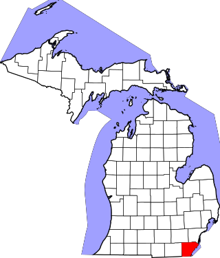
This is a list of the National Register of Historic Places listings in Monroe County, Michigan.

<span class="mw-page-title-main">2015 Toulon Tournament</span> International football competition

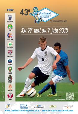
The 2015 Toulon Tournament was the 43rd edition of the Toulon Tournament. The competition began on 27 May and ended on 7 June 2015.

<span class="mw-page-title-main">2019 FIBA Under-16 African Championship</span> International basketball competition

The 2019 FIBA Africa Under-16 Championship, alternatively the 6th Afrobasket U16, was an international basketball competition held in Praia, Cape Verde from 5–14 July 2019. It served as a qualifier for the 2020 FIBA Under-17 Basketball World Cup in Bulgaria.

The 2021 FIBA Under-16 African Championship was an international basketball competition held in Cairo, Egypt from 6–15 August 2021. It served as a qualifier for the 2022 FIBA Under-17 Basketball World Cup in La Nucia and Alicante in Spain.

References

    Commons-logo.svg Media related to Cities in Ivory Coast at Wikimedia Commons