
Rwanda, officially the Republic of Rwanda, is a landlocked country in the Great Rift Valley of Central Africa, where the African Great Lakes region and Southeast Africa converge. Located a few degrees south of the Equator, Rwanda is bordered by Uganda, Tanzania, Burundi, and the Democratic Republic of the Congo. It is highly elevated, giving it the soubriquet "land of a thousand hills", with its geography dominated by mountains in the west and savanna to the southeast, with numerous lakes throughout the country. The climate is temperate to subtropical, with two rainy seasons and two dry seasons each year. Rwanda has a population of over 12.6 million living on 26,338 km2 (10,169 sq mi) of land, and is the most densely populated mainland African country; among countries larger than 10,000 km2, it is the fifth most densely populated country in the world. One million people live in the capital and largest city Kigali.

The transport system in Rwanda centres primarily around the road network. Paved roads lie between the capital, Kigali, and most other major cities and towns in the country. Rwanda is also linked by road with other countries in the African Great Lakes, via which the majority of the country's imports and exports are made.
Transport in Tanzania includes road, rail, air and maritime networks. The road network is 86,472 kilometres (53,731 mi) long, of which 12,786 kilometres (7,945 mi) is classified as trunk road and 21,105 kilometres (13,114 mi) as regional road. The rail network consists of 3,682 kilometres (2,288 mi) of track. Commuter rail service is in Dar es Salaam only. There are 28 airports, with Julius Nyerere International being the largest and the busiest. Ferries connect Mainland Tanzania with the islands of Zanzibar. Several other ferries are active on the countries' rivers and lakes.

Rwanda is located in East Africa, to the east of the Democratic Republic of the Congo, at the co-ordinates 2°00′S30°0′E.

The Rwanda Defence Force is the military of the Republic of Rwanda. The country's armed forces were originally known as the Rwandan Armed Forces (FAR), but following the Rwandan Civil War of 1990–1994 and the 1994 genocide against the Tutsi, the victorious Rwandan Patriotic Front (Inkotanyi) created a new organization and named it the Rwandan Patriotic Army (RPA). Later, it was renamed to its current name.

The Kagera River, also known as Akagera River, or Alexandra Nile, is an East African river, forming part of the upper headwaters of the Nile and carrying water from its most distant source. With a total length of 597 km (371 mi) from its source located in Lake Rweru in Rwanda.
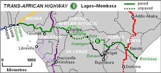
The Lagos–Mombasa Highway or TAH 8 is Trans-African Highway 8 and is the principal road route between West and East Africa. It has a length of 6,259 km (3,889 mi) and is contiguous with the Dakar-Lagos Highway with which it will form the longest east-west crossing of the continent for a total distance of 10,269 km (6,381 mi).

Rutsiro is a district (akarere) in Western Province, Rwanda. Its headquarter is located in Gihango sector.
Lake Rweru is a lake close to the northernmost point of Burundi in central Africa. The northern shore of the lake forms part of Burundi's border with Rwanda. It is the most distant origin point of the Nile River. The Kagera River, considered by many as the start point of the Nile, rises at the northern part of the lake, located in Rwanda.
Lake Cyohoha South or Cyohoha Sud as it is known in Rwanda or Lake Cohoha in Burundi is a small lake in East Africa. It straddles the border between Burundi and Rwanda. In Rwanda, it is known as Cyohoha South to differentiate it from the nearby much smaller Cyohoha North 10 miles North into Rwanda. In Burundi, it is simply known as Cohoha. It is a narrow yet very long lake with many branches. It is 32 km (20 mi) in length, and has an average of 1 km (1 mi) in width. It is largely bisected by the border between Rwanda and Burundi, however, its southern portion extends entirely into Burundi. The lake is 74 km2 (30 sq mi), of which 19 km2 (10 sq mi) are in Rwanda and 55 km2 (20 sq mi) belong to Burundi.
There are several planned railway lines in Rwanda, including a line to Tanzania. Historical railways are limited to three industrial railways.

The East African Railway Master Plan is a proposal for rejuvenating the railways serving Tanzania, Kenya, and Uganda and adding railways to serve Rwanda and Burundi. The objective is to further the economic development of eastern Africa by increasing the efficiency and speed, and lowering the cost, of transporting cargo between major ports on the Indian Ocean coast and the interior.
The Nyabarongo is a major river in Rwanda, part of the upper headwaters of the Nile. With a total length of 351 km (218 mi), it is the longest river entirely in Rwanda. It is extended 421 km (262 mi) in Lake Rweru including a 69 km (43 mi) upper course of Kagera River before joining into Ruvuvu River to form the Kagera River. The river begins its course at the confluence of the rivers Mbirurume and Mwogo in the South West of the country. These two rivers themselves begin in Nyungwe Forest, and are considered by some to be the most distant source of the Nile. From its start, Nyabarongo flows northward for 85 km, and forms the border between the Western and Southern Provinces. At the confluence with the river Mukungwa, the river changes course and flows eastward for 12 km, then to a more South Eastern course for the last 200 km. For the longest stretch of this course, the river serves as the boundary between the Northern and Southern Provinces, then between the City of Kigali and the Southern Province, and lastly between the City of Kigali and the Eastern Province.
Bugarama is a town in western Rwanda.
Gatuna town is a town in northern Rwanda. It is a border town that sits across from the town of Katuna, in neighboring Uganda.
Nemba is a settlement in Rwanda.
The history of rail transport in Burundi is limited to a now closed industrial railway, and a number of proposed railway projects that, as of 2012, had not been implemented.
Lake Mugesera is a lake in the Eastern Province, Rwanda.

Lake Burera or Bulera is a lake of northwestern Rwanda, at the border with Uganda. With an area pf 55 km2 (20 sq mi), it is the second largest lake entirely in Rwanda after Lake Ihema. Considering all other lakes in the country, it would be the 5th largest after Lake Kivu 2,700 km2 (1,040 sq mi) between Rwanda and the Democratic Republic of the Congo, Lake Rweru between Rwanda and Burundi at 133 km2 (50 sq mi) of which only 47 km2 (20 sq mi) are in Rwanda, Lake Ihema and Lake Cohoha 74 km2 (30 sq mi) also shared with Burundi of which only 19 km2 (10 sq mi) are in Rwanda. The lake is located in a densely populated North of the country in Burera District which got its name from this lake. The closet major city is the city of Musanze 25 km (16 mi) West of the lake.
Cyanika is a populated settlement in Rwanda. It sits adjacent to Kyanika, across the international border with neighboring Uganda. Cyanika, also refers to Cyanika Sector, one of the 17 administrative divisions of Burera District.
