Map

This is a list of national parks in Zambia. There are twenty national parks in Zambia, although many of them are not well maintained and so contain no facilities and few animals. Others have high concentrations of animals and are popular with tourists, while two or three are world-famous.
The national parks are administered by the Department of National Parks and Wildlife, an autonomous body responsible to the Ministry of Tourism, Environment and Natural Resources. This Authority took over from the former National Parks and Wildlife Service which suffered from chronic underfunding. Consequently of the 20 parks, five have never had management or facilities and have very little wildlife: Isangano, Lavushi Manda, Lusenga Plain, West Lunga, and Mweru Wantipa; three have substantial wildlife but have hitherto been left undeveloped as a matter of policy or because a neighbouring park has been favoured: North Luangwa, Luambe, and Lukusuzi; and three have wildlife but have been too remote to develop: Liuwa Plain, Sioma Ngwezi, and Nyika Plateau. Of the remainder, most are in quite good shape, except Nsumbu, which went through a decline due to a lack of transport infrastructure, and the zoological park section of Mosi-oa-Tunya National Park which needs rehabilitation.
In approximate order of importance in terms of wildlife resources, the eight main functioning parks, all with access and accommodation[ citation needed ] are:
This article is about the Transport in Zambia.

The Zambezi is the fourth-longest river in Africa, the longest east-flowing river in Africa and the largest flowing into the Indian Ocean from Africa. Its drainage basin covers 1,390,000 km2 (540,000 sq mi), slightly less than half of the Nile's. The 2,574 km (1,599 mi) river rises in Zambia and flows through eastern Angola, along the north-eastern border of Namibia and the northern border of Botswana, then along the border between Zambia and Zimbabwe to Mozambique, where it crosses the country to empty into the Indian Ocean.

Northern Province is one of Zambia's ten provinces. It covers approximately one-sixth of Zambia in land area. The provincial capital is Kasama. The province is made up of 12 districts, namely Kasama District, Chilubi District, Kaputa District, Luwingu District, Mbala District, Mporokoso District, Mpulungu District, Mungwi District, Nsama District, Lupososhi District, Lunte District and Senga Hill District. Currently, only Kasama and Mbala have attained municipal council status, while the rest are still district councils. It is widely considered to be the heartland of the Bemba, one of the largest tribes in Zambia.

Mosi-oa-Tunya National Park is a UNESCO World Heritage Site that is home to one-half of the Mosi-oa-Tunya—"The Smoke that Thunders", known worldwide as Victoria Falls—on the Zambezi River. The river forms the border between Zambia and Zimbabwe, so the falls are shared by the two countries, and the park is twin to the Victoria Falls National Park on the Zimbabwean side.

Southern Province is one of Zambia's ten provinces, and home to Zambia's premier tourist attraction, Mosi-oa-Tunya, shared with Zimbabwe. The centre of the province, the Southern Plateau, has the largest area of commercial farmland of any Zambian province, and produces most of the maize crop.
Luambe National Park is located in the Eastern Province of Zambia. The park is situated north-east of the famous South Luangwa National Park, and south of the North Luangwa National Park. Like its neighbours, it is located in the Luangwa River rift valley.
Water transport and the many navigable inland waterways in Zambia have a long tradition of practical use except in parts of the south. Since draught animals such as oxen were not heavily used, water transport was usually the only alternative to going on foot until the 19th century. The history and current importance of Zambian waterways, as well as the types of indigenous boats used, provide information on this important aspect of Zambian economy.

The wildlife of Zambia refers to the natural flora and fauna of Zambia. This article provides an overview, and outline of the main wildlife areas or regions, and compact lists of animals focusing on prevalence and distribution in the country rather than on taxonomy. More specialized articles on particular groups are linked from here.

The Zambezian flooded grasslands is an ecoregion of southern and eastern Africa that is rich in wildlife.
The biomes and ecoregions in the ecology of Zambia are described, listed and mapped here, following the World Wildlife Fund's classification scheme for terrestrial ecoregions, and the WWF freshwater ecoregion classification for rivers, lakes and wetlands. Zambia is in the Zambezian region of the Afrotropical biogeographic realm. Three terrestrial biomes are well represented in the country . The distribution of the biomes and ecoregions is governed mainly by the physical environment, especially climate.

The T1 or Lusaka–Livingstone Road is the main highway of the Southern Province of Zambia. It begins 55 kilometres south of the city of Lusaka and heads south-west to the principal tourist destination, Victoria Falls in Livingstone, via Mazabuka, Monze, Choma and Kalomo, measuring approximately 430 kilometres (267 mi). The entire route is part of Trans-African Highway network number 4 or Cairo-Cape Town Highway between Cairo and Cape Town.

The following outline is provided as an overview of and topical guide to Zambia:
Zambia, officially known as the Republic of Zambia, is a landlocked country in Southern Africa. The neighbouring countries are the Democratic Republic of the Congo to the north, Tanzania to the north-east, Malawi to the east, Mozambique, Zimbabwe, Botswana, and Namibia to the south, and Angola to the west. The capital city is Lusaka, located in the southeast of the country. The population is concentrated mainly around the capital and the Copperbelt to the northwest.
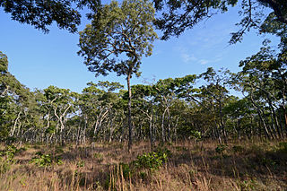
The Central Zambezian miombo woodlands ecoregion spans southern central Africa. Miombo woodland is the predominant plant community. It is one of the largest ecoregions on the continent, and home to a great variety of wildlife, including many large mammals.
Kavango–Zambezi Transfrontier Conservation Area is the second-largest nature and landscape conservation area in the world, spanning the international borders of five countries in Southern Africa. It includes a major part of the Upper Zambezi River and Okavango basins and Delta, the Caprivi Strip of Namibia, the southeastern part of Angola, southwestern Zambia, the northern wildlands of Botswana and western Zimbabwe. The centre of this area is at the confluence of the Zambezi and Chobe Rivers where the borders of Botswana, Namibia, Zambia and Zimbabwe meet. It incorporates a number of notable national parks and nature sites, including Chobe National Park, Hwange National Park, and the Victoria Falls. The region is home to a population of approximately 250,000 animals, including the largest population of African Elephants in the world.
Lavushi Manda National Park is a national park in the Muchinga Province of Zambia with an area of 1,500 sq km. It is the 11th largest of the 20 National Parks in Zambia. The park was initially gazetted as a Game Reserve in 1941, and was declared a National Park in 1972. It is located in a district of the same name (Lavushimanda), with the South Luangwa National Park in the neighbouring Mpika District. It is adjacent to Bangweulu Game Management Area to the northwest, Kafinda Game Management Area lies further west. The chiefdom of Chiundaponde is in the northwest, north lies Luchembe, northwest Chikwanda, east Mpumba, and south lies Muchinka chiefdom. It covers a small range of mountains and hills, and is principally covered in miombo woodlands, with a number of rivers and streams, and a few areas of grassland, both on drier land or in the form of seasonally wet dambos. There are few large mammals, due to poaching in the previous century, but fishing and hiking are possible. Certain antelope species retreat upland to the park from the Bangweulu swamps to the northwest during the rainy season.
The M10 road is a road in Zambia. It goes from Livingstone, through Sesheke and Senanga, to Mongu. The road is approximately 508 kilometres and follows the Zambezi River for its entire length.