List of rivers of Puerto Rico

Last updated

Map with highways and waterways in Puerto Rico Map of Highways, Primary, Secondary, Tertiary Routes in Puerto Rico.svg
Map with highways and waterways in Puerto Rico

List of rivers in Puerto Rico (U.S. Commonwealth), sorted by drainage basin and then alphabetically. There are 47 main rivers and 24 lagoons or reservoirs. [1]

Contents

Most of Puerto Rico's rivers originate in the Cordillera Central . There are four slopes through which rainwater flows towards the sea. According to their orientation they are known as the north or Atlantic slope; southern slope or the Caribbean Sea; the east slope of the Virgin Passage and the Sonda de Vieques and the west slope or the Mona Passage. Due to the generally abundant rain and the flow of its water currents, the most important rivers of Puerto Rico slide down the north slope. Taíno and native people normally built their communities near the rivers. During the Spanish colonization era, the same was true with many pueblos being founded near rivers. [2]

There are about 5,385 miles of river in Puerto Rico; 224 rivers and 553 named streams. [3] [4] [5] [6] Only 8.9 miles of Puerto Rico's rivers have the official U.S. Wild and Scenic River Designation. [7]

Note

Sign on the side of PR-435 in San Sebastian indicating there is a quebrada
(stream) Sign for Quebrada Las Canas, San Sebastian, Puerto Rico.jpg
Sign on the side of PR-435 in San Sebastián indicating there is a quebrada (stream)

A quebrada is a stream. An arroyo or ensenada is a creek. A río is a river. A canal or caño is a channel. A cayo is a cay.

Reservoirs and lagoons

These are also reservoirs and lagoons in Puerto Rico: [1]

  1. Guajataca
  2. Garzas
  3. Dos Bocas
  4. Caonillas
  5. Laguna Tortuguero
  6. La Plata
  7. Cidra
  8. Laguna San José and Laguna Los Corozos
  9. Carraízo
  10. Laguna Piñones and Laguna Torrecilla
  11. Fajardo
  12. Valenciano (in planning)
  13. Patillas
  14. Carite
  15. Toa Vaca
  16. Guayabal
  17. Cerrillos
  18. Garzas
  19. Luchetti
  20. Loco
  21. Laguna Guánica (drained)
  22. Laguna Cartagena (refuge)
  23. Laguna Joyuda
  24. Casei (in planning)
  25. El Guineo
  26. Matrulla

By drainage basin

Tanama in Utuado El Rio Tanama en Utuado, Puerto Rico.jpg
Tanamá in Utuado

Rivers of Puerto Rico listed by drainage basin:

North Coast (Atlantic Ocean)

East Coast (Vieques Passage)

South Coast (Caribbean Sea)

West Coast (Mona Passage)

Alphabetically

A waterway in Puerto Rico Waterway in Puerto Rico.jpg
A waterway in Puerto Rico

See also

Related Research Articles

<span class="mw-page-title-main">Caguas, Puerto Rico</span> City and municipality in Puerto Rico

Caguas is a city and municipality of Puerto Rico located in the Central Mountain Range of Puerto Rico, south of San Juan and Trujillo Alto, west of Gurabo and San Lorenzo, and east of Aguas Buenas, Cidra, and Cayey. Caguas was founded in 1775. The municipality had a population of 127,244 at the 2020 census.

<span class="mw-page-title-main">Index of Puerto Rico–related articles</span>

The following is an alphabetical list of articles related to the Commonwealth of Puerto Rico.

<span class="mw-page-title-main">Villalba, Puerto Rico</span> Town and municipality in Puerto Rico

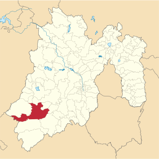
Villalba, originally known as Villa Alba, is a town and municipality of Puerto Rico located in the central region, northeast of Juana Díaz; south of Orocovis; and west of Coamo. Villalba is spread over 6 barrios and Villalba Pueblo. It is part of the Ponce Metropolitan Statistical Area.

Rio Grande is a river flowing to the Gulf of Mexico, forming a part of the Mexican-United States border.

<span class="mw-page-title-main">Tejupilco Municipality</span> Municipality in State of Mexico, Mexico

Tejupilco is a municipality in the State of Mexico, Mexico, located approximately 100 kilometres (62 mi) southwest of the state capital Toluca, along Federal Highway 134. Its municipal seat is Tejupilco de Hidalgo. The municipality has a total area of about 1,327 km2 (512 sq mi), with a contrasting topography ranging from deep ravines and canyons to high ridges; the highest elevation within the municipality reaches some 1,117 metres (3,660 ft) asl. The 2005 census recorded a population of 62,547 inhabitants.

<span class="mw-page-title-main">Río Grande de Arecibo</span> River of Puerto Rico

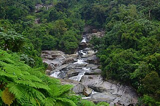
The Río Grande de Arecibo is a river of Puerto Rico. The headwaters lie in the mountains to the south of Adjuntas. From there it flows north until it reaches the Atlantic Ocean near Arecibo. The tributaries lie along the side of the Cerro de Punta and the Utuado pluton. It flows through the northern, passing along a gorge that is 200 m deep and 800–1,200 m wide. It flows through the middle of Puerto Rico.

<span class="mw-page-title-main">Icacos River</span> River in Puerto Rico

The Icacos River, sometimes spelled Hicacos, is a river of Naguabo, Puerto Rico. It is 2.3 miles (3.7 km) long and has received the designation of "Wild and Scenic River" by the National Wild and Scenic Rivers System. This river aids the hydroelectric dam in Naguabo.

The Matrullas River is a river of Ciales and Orocovis, Puerto Rico.

<span class="mw-page-title-main">National Register of Historic Places listings in central Puerto Rico</span> Places in central Puerto Rico listed on the US National Register of Historic Places

This portion of National Register of Historic Places listings in Puerto Rico is along the central mountain region, from Las Marías and Maricao in the central-west to Juncos in the central-east, including the slopes of the Cordillera.

<span class="mw-page-title-main">Porta Cordillera</span> Land-locked tourism region in the central mountainous region of Puerto Rico

Porta Cordillera, or simply Central Region, is a land-locked tourism region located in the central mountainous area of Puerto Rico. Porta Cordillera was officially launched in July 2012 by the Puerto Rico Tourism Company. It consists of 16 municipalities: Aguas Buenas, Cidra, Cayey, Comerío, Aibonito, Naranjito, Barranquitas, Corozal, Orocovis, Morovis, Ciales, Jayuya, Florida, Utuado, Adjuntas and Lares.

Las Minas may refer to:

<span class="mw-page-title-main">Puerto Rico Highway 568</span> Highway in Puerto Rico

Puerto Rico Highway 568 (PR-568) is a road that travels from the municipality of Orocovis to Corozal in Puerto Rico. With a length of 30.1 km (18.7 mi), it begins at its intersection with PR-5155 in downtown Orocovis and ends at PR-159 in western Corozal.

References

  1. 1 2 "Ríos principales de Puerto Rico" (PDF). GIS OTG. US Geological Survey Departamento de Recursos Naturales y Ambientales. Archived (PDF) from the original on 18 September 2017. Retrieved 13 June 2019.
  2. Tesoros naturales de Puerto Rico (in Spanish). Island Finance Corporation. 1996. pp. 14–15.
  3. "Los Ríos" (PDF). Hojas de Nuestro Ambiente. Puerto Rico: DRNA. February 1, 2007. Archived from the original (PDF) on April 1, 2012.
  4. "Puerto Rico". National Wild and Scenic River Systems. Archived from the original on 19 February 2019. Retrieved 18 February 2019.
  5. "Rios de Puerto Rico" (in Spanish). Archived from the original on October 23, 2008.
  6. "Jacksonville District Navigable Waters Lists" (PDF). saj.usace.army.mil. SAJ. Archived (PDF) from the original on 2017-01-26. Retrieved 18 February 2019.
  7. "Rio de la Mina". National Wild and Scenic River System. Archived from the original on 2018-10-02. Retrieved 2019-03-09.