This is a list of township-level divisions of Tibet Autonomous Region (TAR), People's Republic of China (PRC). After province, prefecture, and county-level divisions, township-level divisions constitute the formal fourth-level administrative divisions of the PRC. As of the end of 2014, there are a total of 691 such divisions in TAR, divided into 9 subdistricts, 140 towns, 534 townships, and 8 ethnic townships.
Contents
- Lhasa
- Chengguan District
- Doilungdêqên District
- Dagzê District
- Damxung County
- Lhünzhub County
- Maizhokunggar County
- Nyêmo County
- Qüxü County
- Qamdo (Chamdo)
- Karub District
- Jomda County
- Gonjo County
- Banbar County
- Baxoi County
- Dêngqên County
- Lhorong County
- Markam County
- Riwoqê County
- Zhag'yab County
- Zogang County
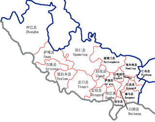
- Xigazê (Shigatse)
- Samzhubzê District
- Bainang County
- Dinggyê County
- Gamba County
- Gyangzê (Gyantse) County
- Gyirong County
- Kangmar County
- Lhazê (Lhatse) County
- Namling County
- Ngamring County
- Nyalam County
- Rinbung County
- Sa'gya County
- Saga County
- Tingri County
- Xaitongmoin County
- Yadong (Dromo) County
- Zhongba County
- Nyingchi
- Bayi District
- Bomê County
- Gongbo'gyamda County
- Mainling County
- Mêdog County
- Nang County
- Zayü County
- Shannan (Lhoka)
- Nêdong District
- Comai County
- Cona County
- Gonggar County
- Gyaca County
- Lhozhag County
- Lhünzê County
- Nagarzê County
- Qonggyai County
- Qusum County
- Sangri County
- Zhanang County
- Nagqu
- Seni District
- Amdo County
- Baingoin County
- Baqên County
- Biru County
- Lhari County
- Nyainrong County
- Nyima County
- Sog County
- Shuanghu (Conyi) County
- Xainza County
- Ngari Prefecture
- Gar County
- Burang County
- Coqên County
- Gê'gyai County
- Gêrzê County
- Rutog County
- Zanda County
- References
- External links