
Lawas is a small town and the capital of Lawas District, Limbang Division, Sarawak, Malaysia. This district area is 3,811.90 square kilometres, and population was 46,200. It is 1,200 km from the state capital, Kuching and 200 km from the capital city of Sabah, Kota Kinabalu.

The Interior Division is an administrative division of the state of Sabah, Malaysia. It occupies the southwest portion of Sabah, bordered by the neighbouring state of Sarawak on its west. With an area of 18,298 square kilometres, it covers 24.9% of Sabah's territory and is home to approximately 14.7% of Sabah's total population. The largest town in the Interior Division is Keningau. Other main towns in this division include Beaufort, Kuala Penyu, Sipitang, Tambunan and Tenom.

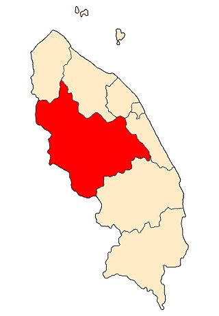
Sipitang is the capital of the Sipitang District in the Interior Division of Sabah, Malaysia. Its population was estimated to be around 4,298 in 2010. It is the closest town in Sabah to the Sarawak border, and is 44 kilometres south of Beaufort and 144 kilometres south of Kota Kinabalu, the state capital and also is 123 kilometres north of Long Pasia, one of the famous attraction in Sabah.

The Jerantut District is a district in north-eastern Pahang, Malaysia. Jerantut is home to the National Park.
Hulu Terengganu is an interior district of Terengganu, Malaysia. The seat of the district is Kuala Berang, located about 40 km (25 mi) from the state capital, Kuala Terengganu. The local government of this district is Hulu Terengganu District Council.

The Baram River is a river in Sarawak on the island of Borneo. The river originates in the Kelabit Highlands, a watershed demarcated by the Iran Mountains of East Kalimantan, which form a natural border with Sarawak. The river flows westwards through tropical rainforest to the South China Sea. The Baram River terminates in a delta, which is subdivided into two units: East Barma Delta of Middle-Late Miocene age and West Baram Delta of Late Miocene-Quaternary age. The western unit is composed of mudstones enriched in organic components which constitute substantial oil and gas reserves.

Ba'kelalan is a group of nine villages at Maligan Highlands of Limbang Division, Sarawak, Malaysia about 3,000 feet (910 m) above sea level and 4 km from the border with Indonesian Kalimantan and 150 km from the nearest town of Lawas. There are nine villages in Ba'kelalan. The villagers here belong to the Lun Bawang tribe.

The Lun Bawang is an ethnic group found in Central Northern Borneo. They are indigenous to the southwest of Sabah and the northern region of Sarawak, highlands of North Kalimantan and Brunei.

Kutai Kartanegara Regency is a regency of East Kalimantan Province, Indonesia. It has a land area of 27,263.10 km2 and a water area of 4,097 km2, geographically located between 1°18′40″S and 116°31′36″E. The population of the regency was 626,286 at the 2010 Census and 729,382 at the 2020 Census; the official estimate as of mid-2023 was 788,113. The town of Tenggarong is the capital of the regency.

Moyo is an island off the north coast of Sumbawa Island, in Sumbawa Regency, West Nusa Tenggara province, Indonesia.

The Borneo Evangelical Church or SIB is an evangelical Christian denomination in Malaysia. The church was organised in 1959 from the work of the Borneo Evangelical Mission with help from the Christian and Missionary Alliance Church in Indonesia, an ethnic Torajan-based Protestant church in South Sulawesi province, which is currently headquartered nationally in Senen, Central Jakarta.
Long Selaan is a settlement in Sarawak, Malaysia. It lies approximately 553.9 kilometres (344 mi) east-north-east of the state capital Kuching.
Baru Bian is a Malaysian politician and lawyer who has served as Member of the Sarawak State Legislative Assembly (MLA) for Ba'kelalan since April 2011. He served as the Minister of Works in the Pakatan Harapan (PH) administration under former Prime Minister Mahathir Mohamad from July 2018 to the collapse of the PH administration in February 2020 and the Member of Parliament (MP) for Selangau from May 2018 to November 2022. He is a member of the Progressive Democratic Party (PDP), a component party of the Gabungan Parti Sarawak (GPS) coalition and was a member of the Parti Sarawak Bersatu (PSB), People's Justice Party (PKR), a component party of the PH and formerly Pakatan Rakyat (PR) coalitions. He has also served as the Vice President of PDP since April 2024. He also served as the State Chairman of PKR of Sarawak from December 2009 to his resignation from the party in February 2020. He became the first ever federal minister of the Lun Bawang ethnicity in the Malaysian history.
Sarawak's population is very diverse, comprising many races and ethnic groups. Sarawak has more than 40 sub-ethnic groups, each with its own distinct language, culture and lifestyle. This makes Sarawak demography very distinct and unique compared to its Peninsular counterpart. However, it largely mirrors to other territories in Borneo – Sabah, Brunei and Kalimantan.
Long Sukang is a Lun Bawang settlement in the Lawas division of Sarawak, Malaysia. It lies approximately 660.7 kilometres (411 mi) east-north-east of the state capital Kuching.

Ulu Temburong National Park is the first national park to be established in Brunei, protected since 1991. The park is in Temburong District in eastern Brunei, and covers about 40% of the district in the south at 550 square kilometres (210 sq mi). It is within the Batu Apoi Forest Reserve. The park contains unspoiled jungle and is known as the "Green Jewel of Brunei", described as "the finest example of the sultanate's successful forest protection policy". The principal rivers are the Temburong and Belalong Rivers. It is an important ecotourism centre in Brunei and hosts the Ulu Ulu Resort. The Peradayan Forest Reserve is also located in the district.
Küre Mountains National Park, in the Black Sea Region of Turkey, was established in 2000. The national park stretches over the mountain range of Küre Mountains and is located in the districts Pınarbaşı, Cide, Şenpazar, Azdavay, Kurucaşile, Ulus, and Amasra, of the Kastamonu and Bartın provinces. It contains within the borders of the Black Sea Region, extending from the west bank of the Bartın River to the east bank of the Kızılırmak River, covering a distance of 300 kilometers. The Küre Mountains National Park (KMNP) is one of Turkey's 41 national parks, covering 80,000 hectares of protected area featuring diverse terrain and ecosystems. Within its boundaries lies a core zone of 37,753 ha with an average elevation of 500 m.
The Institute for Biodiversity and Environmental Research in Brunei Darussalam is a research institute of Universiti Brunei Darussalam (UBD) dedicated to biodiversity and environmental sciences research and education. IBER's location within the northwest Borneo hotspot offers unique opportunities for long-term studies in both terrestrial and marine tropical ecosystems.

Protected areas of Brunei are established by the Government of Brunei, in accordance with national development objectives and global biogeoecological strategies in which forests play an important role. The country's marine protected areas remained at 0.2% in 2022. As of 2011, nearly half of Brunei Darussalam is still primary forest, however this coverage is dwindling and only 17% of the country is officially protected.

The Sipitang District is an administrative district in the Malaysian state of Sabah, part of the Interior Division which also includes the districts of Beaufort, Keningau, Kuala Penyu, Nabawan, Tambunan and Tenom. The capital of the district is in Sipitang Town. The ecotourism village of Long Mio and Long Pasia is located in this district, while the small town of Sindumin serves as a gateway to the state of Sarawak.
