
The Crystal Palace was a cast iron and plate glass structure, originally built in Hyde Park, London, to house the Great Exhibition of 1851. The exhibition took place from 1 May to 15 October 1851, and more than 14,000 exhibitors from around the world gathered in its 990,000 square feet (92,000 m2) exhibition space to display examples of technology developed in the Industrial Revolution. Designed by Joseph Paxton, the Great Exhibition building was 1,851 feet (564 m) long, with an interior height of 128 feet (39 m). The erection itself was a representation of modern architecture and modern industry that was developing with the Industrial Revolution, and the structure was three times the size of St Paul's Cathedral.

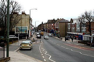
Penge is an area of South East London, England, within the London Borough of Bromley. It is located 3.5 miles (5.6 km) west of Bromley, 3.7 miles (6.0 km) north east of Croydon and 7.1 miles (11.4 km) south east of Charing Cross, the traditional centre of London.

The London Borough of Bromley is the southeasternmost of the 32 London boroughs that make up Greater London, bordering the county of Kent, which most of Bromley was part of before 1965. The borough's population is an estimated 332,336. It is named after Bromley, its principal town; other major towns are Penge, Hayes, West Wickham, Chislehurst, Beckenham and Orpington. The local authority is Bromley London Borough Council.

Beckenham is a constituency represented in the House of Commons of the Parliament of the United Kingdom since 2010 by Bob Stewart, a Conservative.
Langley Park School for Boys is a boys secondary academy school in Beckenham in the London Borough of Bromley, with a co-ed sixth form. On 31 March 2011, the school converted from a Foundation School to an academy and its current status is that of an "Academy Converter".

Battersea was a civil parish and metropolitan borough in the County of London, England. In 1965, the borough was abolished and its area combined with parts of the Metropolitan Borough of Wandsworth to form the London Borough of Wandsworth. The borough was administered from Battersea Town Hall on Lavender Hill. That building is now Battersea Arts Centre.

Lieutenant Colonel Joseph Petrus Hendrik Crowe VC was the second South African-born recipient of the Victoria Cross, the highest and most prestigious award for gallantry in the face of the enemy that can be awarded to British and Commonwealth forces.

Penge West railway station is located in Penge, a district of the London Borough of Bromley in south London. The station is operated by London Overground, with Overground and Southern trains serving the station. Thameslink and some Southern services pass through the station. It is 7 miles 15 chains (11.57 km) down the line from London Bridge, in Travelcard Zone 4.

Penge East railway station is on the Chatham main line in England, serving part of the Penge and Sydenham areas in the London Borough of Bromley, south London. It is 7 miles 15 chains (11.6 km) down the line from London Victoria and is situated between Sydenham Hill and Kent House.

Kent House railway station is on the Chatham Main Line in England, serving part of the Penge and Beckenham areas in the London Borough of Bromley, south London. It is 7 miles 66 chains (12.6 km) down the line from London Victoria and is situated between Penge East and Beckenham Junction. It takes its name from the nearby Kent House farm, the first house in the historic county of Kent after crossing the Surrey border.

Penge was a civil parish and a local government district located to the southeast of London, England. It included the settlements of Penge, Anerley and part of Crystal Palace. It was part of the London postal district, Metropolitan Police District and, from 1933, the London Passenger Transport Area. In 1965 the urban district was abolished by the London Government Act 1963 and it became part of Greater London, being combined with other districts to form the London Borough of Bromley.
Anerley is an area of south east London, England, within the London Borough of Bromley and formerly the historic county of Surrey. It is located 7 miles (11 km) south south-east of Charing Cross, to the east of Crystal Palace/Upper Norwood, south of Penge, west of Elmers End and north of South Norwood.

Lewisham West and Penge is a constituency in Greater London created in 2010 and represented in the House of Commons of the UK Parliament since 2017 by Ellie Reeves of the Labour Party.
Penge Common was an area of north east Surrey and north west Kent which now forms part of London, England; covering most of Penge, all of Anerley, and parts of surrounding suburbs including South Norwood. It abutted the Great North Wood and John Rocque's 1745 map of London and its environs showed that Penge Common now included part of that wood.
In the ticketing system of the British rail network, tickets are normally issued to and from individual stations. In some instances, when there is more than one station in a town or other locality—especially where these are on different routes—it may be desirable for passengers to be able to travel to one station and back from another, or more generally to be able to choose which of the stations they wish to travel to. To accommodate this requirement, British Rail introduced a series of station groups: notional "common locations" to which tickets from stations outside that group would be issued.
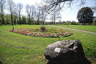
Betts Park is a public park in Penge, London Borough of Bromley, in London, England. It has a number of attractions, including part of the old Croydon Canal. It was opened in December 1928.
Djämes Braun is a Danish reggae and dancehall act made up of Pilfinger and former member Kenno.
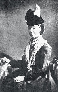
The Murder of Harriet Staunton took place in the London suburb of Penge in April 1877. Harriet Staunton died in a Penge lodging house on 13 April, five days after her one-year-old child, Thomas Staunton, died of malnutrition at Guy's Hospital. In September of the same year, Harriet's husband Louis Staunton was convicted of wilful murder at the Old Bailey together with his partner Alice Rhodes, his brother Patrick Staunton and Patrick's wife Elizabeth. All four were sentenced to death by hanging but the sentences were later commuted to terms of imprisonment after doubts were raised concerning the medical evidence and the impartiality of the presiding judge.
The 1964 Bromley Council election took place on 7 May 1964 to elect members of Bromley London Borough Council in London, England. The whole council was up for election and the Conservative party gained control of the council.


