
Japan is an archipelagic country comprising a stratovolcanic archipelago over 3,000 km (1,900 mi) along the Pacific coast of East Asia. It consists of 14,125 islands. The five main islands are Hokkaido, Honshu, Kyushu, Shikoku, and Okinawa. The other 14,120 islands are classified as "remote islands" by the Japanese government. The Ryukyu Islands and Nanpō Islands are south and east of the main islands.

The Ring of Fire is a tectonic belt of volcanoes and earthquakes.

A convergent boundary is an area on Earth where two or more lithospheric plates collide. One plate eventually slides beneath the other, a process known as subduction. The subduction zone can be defined by a plane where many earthquakes occur, called the Wadati–Benioff zone. These collisions happen on scales of millions to tens of millions of years and can lead to volcanism, earthquakes, orogenesis, destruction of lithosphere, and deformation. Convergent boundaries occur between oceanic-oceanic lithosphere, oceanic-continental lithosphere, and continental-continental lithosphere. The geologic features related to convergent boundaries vary depending on crust types.

The Japan Trench is an oceanic trench part of the Pacific Ring of Fire off northeast Japan. It extends from the Kuril Islands to the northern end of the Izu Islands, and is 8,046 metres (26,398 ft) at its deepest. It links the Kuril–Kamchatka Trench to the north and the Izu–Ogasawara Trench to its south with a length of 800 kilometres (497 mi). This trench is created as the oceanic Pacific plate subducts beneath the continental Okhotsk Plate. The subduction process causes bending of the down going plate, creating a deep trench. Continuing movement on the subduction zone associated with the Japan Trench is one of the main causes of tsunamis and earthquakes in northern Japan, including the megathrust Tōhoku earthquake and resulting tsunami that occurred on 11 March 2011. The rate of subduction associated with the Japan Trench has been recorded at about 7.9–9.2 centimetres (3.1–3.6 in)/yr.

A volcanic arc is a belt of volcanoes formed above a subducting oceanic tectonic plate, with the belt arranged in an arc shape as seen from above. Volcanic arcs typically parallel an oceanic trench, with the arc located further from the subducting plate than the trench. The oceanic plate is saturated with water, mostly in the form of hydrous minerals such as micas, amphiboles, and serpentines. As the oceanic plate is subducted, it is subjected to increasing pressure and temperature with increasing depth. The heat and pressure break down the hydrous minerals in the plate, releasing water into the overlying mantle. Volatiles such as water drastically lower the melting point of the mantle, causing some of the mantle to melt and form magma at depth under the overriding plate. The magma ascends to form an arc of volcanoes parallel to the subduction zone.

The Kuril–Kamchatka Trench or Kuril Trench is an oceanic trench in the northwest Pacific Ocean. It lies off the southeast coast of Kamchatka and parallels the Kuril Island chain to meet the Japan Trench east of Hokkaido. It extends from a triple junction with the Ulakhan Fault and the Aleutian Trench near the Commander Islands, Russia, in the northeast, to the intersection with the Japan Trench in the southwest.

The islands of Japan are primarily the result of several large ocean movements occurring over hundreds of millions of years from the mid-Silurian to the Pleistocene, as a result of the subduction of the Philippine Sea Plate beneath the continental Amurian Plate and Okinawa Plate to the south, and subduction of the Pacific Plate under the Okhotsk Plate to the north.

The Okhotsk microplate is a proposed minor tectonic plate covering the Kamchatka Peninsula, Magadan Oblast, and Sakhalin Island of Russia; Hokkaido, Kantō and Tōhoku regions of Japan; the Sea of Okhotsk, as well as the disputed Kuril Islands.

The Philippine Trench is a submarine trench to the east of the Philippines. The trench is located in the Philippine sea of the western North Pacific Ocean and continues NNW-SSE. It has a length of approximately 1,320 kilometres and a width of about 30 km (19 mi) from the center of the Philippine island of Luzon trending southeast to the northern Maluku island of Halmahera in Indonesia. At its deepest point, the trench reaches 10,540 meters.

The Izu–Bonin–Mariana (IBM) arc system is a tectonic plate convergent boundary in Micronesia. The IBM arc system extends over 2800 km south from Tokyo, Japan, to beyond Guam, and includes the Izu Islands, the Bonin Islands, and the Mariana Islands; much more of the IBM arc system is submerged below sealevel. The IBM arc system lies along the eastern margin of the Philippine Sea Plate in the Western Pacific Ocean. It is the site of the deepest gash in Earth's solid surface, the Challenger Deep in the Mariana Trench.
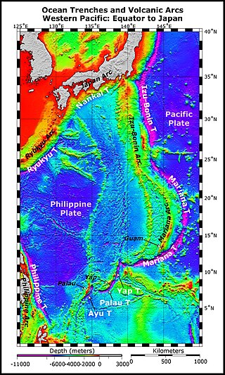
The Izu–Ogasawara Trench, also known as Izu–Bonin Trench, is an oceanic trench in the western Pacific Ocean, consisting of the Izu Trench and the Bonin Trench.

The Sagami Trough also Sagami Trench, Sagami Megathrust, or Sagami Subduction Zone is a 340-kilometre (210 mi)long trough, which is the surface expression of the convergent plate boundary where the Philippine Sea Plate is being subducted under the Okhotsk Plate. It stretches from the Boso Triple Junction in the east, where it meets the Japan Trench, to Sagami Bay in the west, where it meets the Nankai Trough. It runs north of the Izu Islands chain and the Izu–Bonin–Mariana Arc (IBM).

The Mariana Plate is a micro tectonic plate located west of the Mariana Trench which forms the basement of the Mariana Islands which form part of the Izu–Bonin–Mariana Arc. It is separated from the Philippine Sea Plate to the west by a divergent boundary with numerous transform fault offsets. The boundary between the Mariana and the Pacific Plate to the east is a subduction zone with the Pacific Plate subducting beneath the Mariana. This eastern subduction is divided into the Mariana Trench, which forms the southeastern boundary, and the Izu–Ogasawara Trench the northeastern boundary. The subduction plate motion is responsible for the shape of the Mariana plate and back arc.

In the geology of the Philippines, the Philippine Mobile Belt is a complex portion of the tectonic boundary between the Eurasian Plate and the Philippine Sea Plate, comprising most of the country of the Philippines. It includes two subduction zones, the Manila Trench to the west and the Philippine Trench to the east, as well as the Philippine Fault System. Within the Belt, a number of crustal blocks or microplates which have been shorn off the adjoining major plates are undergoing massive deformation.
The Philippine Fault System is a major inter-related system of geological faults throughout the whole of the Philippine Archipelago, primarily caused by tectonic forces compressing the Philippines into what geophysicists call the Philippine Mobile Belt. Some notable Philippine faults include the Guinayangan, Masbate and Leyte faults.

Boso Triple Junction is a triple junction off the coast of Japan; it is one of two known examples of a trench-trench-trench triple junction on the Earth. It is the meeting point of the North American Plate to the north, the Pacific Plate to the east and the Philippine Sea Plate to the south.

The Pacific Ocean evolved in the Mesozoic from the Panthalassic Ocean, which had formed when Rodinia rifted apart around 750 Ma. The first ocean floor which is part of the current Pacific Plate began 160 Ma to the west of the central Pacific and subsequently developed into the largest oceanic plate on Earth.
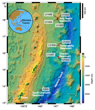
Mud volcanoes in the Mariana fore-arc are a hydrothermal geologic landform that erupt slurries of mud, water, and gas. There are at least 10 mud volcanoes in the Mariana fore-arc that are actively erupting, including the recently studied Conical, Yinazao, Fantagisna, Asut Tesoro, and South Chamorro serpentinite mud volcanoes. These mud volcanoes erupt a unique serpentinite mud composition that is related to the geologic setting in which they have formed. Serpentinite mud is the product of mantle metasomatism due to subduction zone metamorphism and slab dehydration. As a result, the serpentinite mud that erupts from these mud volcanoes often contains pieces of mantle peridotite material that has not fully altered during the serpentinization process. In addition to pieces of altered mantle material, pieces of subducted seamounts have also been found within the serpentinite muds. Serpentinite mud volcanoes in the Mariana fore-arc are often located above faults in the fore-arc crust. These faults act as conduits for the hydrated mantle material to ascend towards the surface. The Mariana mud volcanoes provide a direct window into the process of mantle hydration that leads to the production of arc magmas and volcanic eruptions.

