Rembau District

Last updated
Rembau District
Daerah Rembau
Other transcription(s)
   Jawi رمباو
   Chinese 林茂县
   Tamil ரெம்பாவ்
The Logo of Rembau District Council.png
Negeri sembiland - rembau.PNG
Location of Rembau District in Negeri Sembilan
Rembau District
Malaysia location map.svg
Red pog.svg
Rembau District
Location of Rembau District in Malaysia
Coordinates: 2°35′N102°05′E / 2.583°N 102.083°E / 2.583; 102.083
Country Flag of Malaysia 23px.svg  Malaysia
State Flag of Negeri Sembilan.svg  Negeri Sembilan
Seat Rembau
Local area government(s) Rembau District Council
Government
  District officerAmino Agos Suyub [1]
Area
[2]
  Total415.12 km2 (160.28 sq mi)
Population
 (2010) [3]
  Total41,325
  Density100/km2 (260/sq mi)
Time zone UTC+8 (MST)
  Summer (DST) UTC+8 (Not observed)
Postcode
71xxx
Calling code +6-06
Vehicle registration plates N
Rembau
Luak Rembau
لواق رمباو
Sempadan luak di Negeri Sembilan.jpg
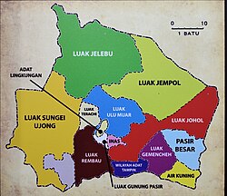
Luak of Rembau relative to other luaks in Negeri Sembilan
Country Malaysia
State Negeri Sembilan
Adat institutionUndang Luak Rembau
Government
   Undang Luak RembauVacant

The Rembau District is a district that is located in the state of Negeri Sembilan, Malaysia. The district is a stronghold of the matrilineal system known as adat perpatih , a customary practice inherited from the Minangkabaus, of Sumatra. [4] The district borders Seremban District to the north, Port Dickson District to the west, Tampin District to the east, Kuala Pilah District to the northeast and Alor Gajah District, Malacca to the southwest.

Contents

Rembau still maintains the old district ruler, which used to be called the district head or Penghulu. Now the title is Yang Teramat Mulia Undang Luak Rembau. He is one of the electors to the throne of Yang di-Pertuan Besar of Negeri Sembilan, besides Sungai Ujong, Jelebu, Johol and Tampin.

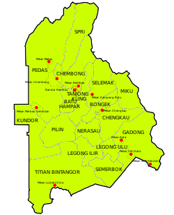
Administrative divisions

Map of Rembau District, Negeri Sembilan.svg

Rembau District consists of 17 mukims, which are: [5]

Demographics

Historical population
YearPop.±%
1991 34,823    
2000 36,848+5.8%
2010 41,988+13.9%
2020 47,278+12.6%
Source: [6]

Federal Parliament and State Assembly Seats

List of Rembau district representatives in the Federal Parliament (Dewan Rakyat)

ParliamentSeat NameMember of ParliamentParty
P131 Rembau Mohamad Hasan Barisan Nasional (UMNO)

List of Rembau district representatives in the State Legislative Assembly (Dewan Undangan Negeri)

ParliamentStateSeat NameState AssemblymanParty
P131N26 Chembong Zaifulbahri Idris Barisan Nasional (UMNO)
P131N28 Kota Suhaimi Aini Barisan Nasional (UMNO)

See also

Related Research Articles

<span class="mw-page-title-main">Negeri Sembilan</span> State of Malaysia

Negeri Sembilan, historically spelled as Negri Sembilan, is a state in Malaysia which lies on the western coast of Peninsular Malaysia. It borders Selangor on the north, Pahang in the east, and Malacca and Johor to the south.

<span class="mw-page-title-main">Jelebu District</span> District in Negeri Sembilan, Malaysia

The Jelebu District is the second largest district in Negeri Sembilan, Malaysia after Jempol, with a population over 40,000. Jelebu borders on the Seremban District to its west and Kuala Pilah District to its south, Jempol District to its southeast, Bentong and Bera Districts, Pahang to its east and Hulu Langat District, Selangor to the north. Jelebu is a suburban district with blossoming semi-agricultural industry. Jelebu is also a parliamentary constituency of the Dewan Rakyat in the Malaysian Parliament. Kuala Klawang is the principal town of the district.

<span class="mw-page-title-main">Kerian District</span> District of Malaysia in Perak

The Kerian District is an administrative district in Perak, Malaysia. It covers the northwestern corner of Perak, bordering the states of Penang and Kedah to the north; the main town of Parit Buntar is located a mere 37 km (23 mi) southeast of George Town, Penang's capital city. The district is well known for Bukit Merah, a popular tourist destination.

<span class="mw-page-title-main">Jasin District</span> District in Melaka, Malaysia

Jasin District is one of the three administrative district in Malacca, Malaysia. It borders Tangkak District of Johor to the east, Tampin District of Negeri Sembilan to the north and Alor Gajah District and Melaka Tengah District to the west. The district capital is Jasin Town.

<span class="mw-page-title-main">Perak Tengah District</span> District of Malaysia in Perak

Perak Tengah District is a district in Perak, Malaysia. It is administered by the Perak Tengah District Council, which is based at the town of Seri Iskandar. Parit is however the largest settlement in the area. The district is well known for its historical sites in the Pasir Salak. Smaller towns in the district include Bota, Lambor and Kampung Gajah.

<span class="mw-page-title-main">Tampin (town)</span> Town and district capital in Negeri Sembilan, Malaysia

Tampin is a town in Tampin District, Negeri Sembilan, Malaysia, which borders Pulau Sebang town in Alor Gajah District, Malacca. It is situated at the southern tip of the longest mountain range in Malaysia, the Titiwangsa Mountains.

<span class="mw-page-title-main">Jempol District</span> District in Negeri Sembilan, Malaysia

The Jempol District is the largest district in the Malaysian state of Negeri Sembilan. The district borders Jelebu District to the northwest, Kuala Pilah District to the west, Tampin District to the south, Bera District, Pahang to the northeast and Segamat District, Johor to the east. Bandar Seri Jempol and Bahau are the principal towns in Jempol.

<span class="mw-page-title-main">Alor Gajah District</span> District in Melaka, Malaysia

Alor Gajah District is one of the three administrative districts in Malacca, Malaysia. It borders Tampin District, Rembau District and Port Dickson District in Negeri Sembilan to the north and borders Jasin District and Melaka Tengah District in the east and south respectively.

<span class="mw-page-title-main">Bera District</span> District of Malaysia in Pahang

The Bera District is a district in southwestern Pahang, Malaysia, bordering Negeri Sembilan and Johor.

<span class="mw-page-title-main">Kuala Pilah District</span> District in Negeri Sembilan, Malaysia

The Kuala Pilah District is a district in central Negeri Sembilan, Malaysia. Its seat is the town of Kuala Pilah.

<span class="mw-page-title-main">Melaka Tengah District</span> Administrative district in Malacca, Malaysia

Melaka Tengah District is one of the three administrative districts in Malacca, Malaysia. It borders Alor Gajah District to the north and Jasin District to the east. The capital of the state, Malacca City, is located in this district. This district is the major destination of tourists in Malacca as most historical spots are situated within it.

<span class="mw-page-title-main">Padang Terap District</span> District of Malaysia in Kedah

The Padang Terap District is a district in Kedah, Malaysia. It is governed by the Padang Terap District Council. Padang Terap District shares a border with Thailand to the north, and with Sik District and Pendang District to the west. It is the third largest district in the State of Kedah, with Kuala Nerang serving as its administrative center.

<span class="mw-page-title-main">Larut, Matang and Selama District</span> District of Perak, Malaysia

The Larut, Matang and Selama District is a district of Perak, Malaysia. Taiping is the capital town of this district. Larut, Matang and Selama used to be three small different districts and they merged into one larger district later. Larut, Matang and Selama houses Taiping, Perak's second largest city and former state capital. Other towns in the region include Changkat Jering, Terong, Matang, Kuala Sepetang and Selama. The region borders the state of Kedah on the north, the Kerian District on the northwest, the Hulu Perak and Kuala Kangsar District on the east, and the Manjung District on the south.

<span class="mw-page-title-main">Seremban District</span> District in Negeri Sembilan, Malaysia

The Seremban District is one of 7 districts in Negeri Sembilan, Malaysia. This is where the capital of Negeri Sembilan, Seremban is located.

<span class="mw-page-title-main">Kuantan District</span> District of Malaysia in Pahang

The Kuantan District is a district in Pahang, Malaysia. Located in the north-east of Pahang, the district bordered Kemaman District of Terengganu on the north, South China Sea on the east, Jerantut District and Maran District on the west and Pekan District on the south.

<span class="mw-page-title-main">Port Dickson District</span> District in Negeri Sembilan, Malaysia

Port Dickson District is a district in Negeri Sembilan, Malaysia. It is the only coastal district in Negeri Sembilan. The district borders Sepang District, Selangor to the north, the Strait of Malacca to the west, Seremban District to the northeast, Rembau District to the east, and Alor Gajah District, Malacca to the south. It also surrounds Tanjung Tuan, an exclave of Malacca under the jurisdiction of Alor Gajah District, to its southwest.

<span class="mw-page-title-main">Temerloh District</span> District of Malaysia in Pahang

Temerloh District is a district in Pahang, Malaysia. The district consists of two areas, the 1,442-square-kilometre (557 sq mi) Municipal Council Area (64.08%) and the 808-square-kilometre (312 sq mi) outer Municipal Council Area (35.92%). Temerloh district is bordered by Maran District on the east, Bentong District on the west, Jerantut District on the north, and Bera District on the south.

<span class="mw-page-title-main">Tampin District</span> District in Negeri Sembilan, Malaysia

The Tampin District is a district in Negeri Sembilan, Malaysia. The district covers 878.69 square kilometres (339.26 sq mi) and is further divided into four adat socio-political provinces (luaks): Tampin Adat Territory, Ayer Kuning, Gemencheh and Pasir Besar.

<span class="mw-page-title-main">Pekan District</span> District of Malaysia in Pahang

The Pekan District is a district in Pahang, Malaysia. Located in the east of Pahang, the district borders Kuantan District on the north, South China Sea on the east, Maran District on the west and Rompin District on the south.

<span class="mw-page-title-main">Kuala Kangsar District</span> District in Perak, Malaysia

The Kuala Kangsar District is a district in Perak, Malaysia. Kuala Kangsar shares its borders with Larut, Matang and Selama at the west, Hulu Perak at the north, Gua Musang of Kelantan at the east, Kinta at the south, Perak Tengah and Manjung at the southwest. The seat of this district is the town of Kuala Kangsar.

References

  1. "Pejabat Daerah & Tanah Rembau - Perutusan Pegawai Daerah". Rrembau.ns.gov.my. Retrieved 19 December 2017.
  2. "Pejabat Daerah & Tanah Rembau - Latar Belakang". Rembau.ns.gov.my. Retrieved 19 December 2017.
  3. "Population Distribution and Basic Demographic Characteristics, 2010" (PDF). Department of Statistics, Malaysia. Archived from the original (PDF) on 22 May 2014. Retrieved 19 April 2012.
  4. "330 penduduk Rembau terima manfaat SKSJ". Utusan.com.my. Retrieved 19 December 2017.
  5. "PROFIL DAERAH" (PDF). Apps.water.gov.my. Retrieved 19 December 2017.
  6. "Key Findings of Population and Housing Census of Malaysia 2020" (pdf) (in Malay and English). Department of Statistics, Malaysia. ISBN   978-967-2000-85-3.