Richmond Hill, London

Last updated

The south-westerly section of the view from Terrace Walk on Richmond Hill River Thames from Richmond Hill down path.jpg
The south-westerly section of the view from Terrace Walk on Richmond Hill
A small corner of the Terrace Gardens Terrace Gardens.jpg
A small corner of the Terrace Gardens
The former Royal Star and Garter Home for disabled ex-servicemen on top of the hill Star Garter.JPG
The former Royal Star and Garter Home for disabled ex-servicemen on top of the hill
Robert Kirsch's memorial bench, Terrace Gardens Richmond Hill, Robert Kirsch's bench, American writer and critic.jpg
Robert Kirsch's memorial bench, Terrace Gardens
Wales, Central and S England slope map 50 m.png
This slope map highlights the hill's slope as the light area at centre-right.

Richmond Hill in Richmond and Petersham, London, is a hill that begins gently in the north and north-east side of Richmond town and through its former fields, orchards and vineyard to a point just within Richmond Park, the deer park emparked and enclosed by Charles I.

Contents

Topography

The straight southwest slope is steepest, falling away to Petersham meadows by the Thames and is a backdrop to Kingston and Richmond Bridges. Other returns to the flood plain are more complex across and beyond the park due to semi-natural ponds and dry and wet running vales feeding an easterly draining brook. The park has further upland Wimbledon Common and Putney Heath beyond. On, and gently scaling the steep fluvial terrace, is residential street Richmond Hill. [lower-alpha 1] It is built up only on its higher (northeast) side from the Richmond Bridge corner of the town centre to the hilltop fronted by a cinema, homes, eateries and hotel-restaurants. It is one-way along its bulk.

Unique scenery

The hill offers the only view in England to be protected by an Act of Parliament the Richmond, Ham and Petersham Open Spaces Act passed in 1902to protect the land on and below it and thus preserve the fine views to the west and south. Two years before the wooded isle centrepiece of the view, Glover's Island (also known as Clam Island), was bought by a local resident and given to the Richmond Corporation (Borough) in return for the latter noting against its records that it and its successors would not develop the isle.

Immortalised in paintings by John Wootton, Sir Joshua Reynolds and J. M. W. Turner, [1] [2] it was described by Sir Walter Scott as "an unrivalled landscape". It was this view that inspired the name of Richmond, Virginia, after the colonial founder of the city, William Byrd II, noticed a curve in the James River that remarkably resembled this meander.

Terrace Gardens and Terrace Walk

The scenic panorama may be viewed from Terrace Walk, laid out near the top of the hill in the 18th century. This promenade surmounts the Terrace Gardens [3] [4] [5] and both are Grade II* listed in Historic England's Register of Parks and Gardens of Special Historic Interest in England.

History

As the town of Richmond developed from its founding in the early 16th century, after Henry VII had established Richmond Palace, the attributes of the hill naturally attracted desirable residential and commercial development – with the result that many large, ornate properties came and went on the hill over the centuries, some of them with famous or notable persons as owners or occupiers. Newer waves and subdivisions of these have continued, subject to external stylistic conformity. [6] This three-times extended conservation area is "almost entirely surrounded" by others. [6]

The original homes on Richmond Hill were set back in what is now The Vineyard, including Clarence House, [7] Halford House, [8] Michel's Almshouses [9] and Vineyard House.

Richmond Hill shares with Ham and Petersham TW10 postcodes.

Etymology

The last two syllables (mond, hill) are an unlinked pleonasm (tautology) unapparent to native speakers. Mond [lower-alpha 2] and large hill are cognate. The origin is as a description of a place in France. This came across due to a noble style of at least 1071 Lord of (seigneur de) Richmond/t, associated with the Harrying of the North and thus Richmond, North Yorkshire. This settled into the title of Earl of Richmond briefly in its history borne by Henry VII of England. It was popularised from his local development of Richmond Palace to replace Shene Palace, precisely as the manor name had already changed and parish name would change. The associated settlement took the same name; for some years the two names were often used in conjunction (for example, "Shene otherwise called Richemount"). [10] [11]

Footnotes

  1. Classed as the B321
  2. Mound and Mount are corruptions of mont, as is the non-word mond, which bore a longer vowel sound in most Old Norman French. An unusually strong similarity exists in phonetics with the term's Latin root mōns, montes (genitive).

Related Research Articles

<span class="mw-page-title-main">Petersham, London</span> Human settlement in England

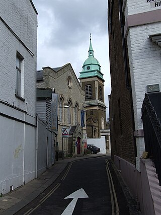
Petersham is a village in the London Borough of Richmond upon Thames on the east of the bend in the River Thames south of Richmond, which it shares with neighbouring Ham. It provides the foreground of the scenic view from Richmond Hill across Petersham Meadows, with Ham House further along the river. Other nearby places include Twickenham, Isleworth, Teddington, Mortlake, and Roehampton.

<span class="mw-page-title-main">London Borough of Richmond upon Thames</span> London borough in United Kingdom

The London Borough of Richmond upon Thames in southwest London, England, forms part of Outer London and is the only London borough on both sides of the River Thames. It was created in 1965 when three smaller council areas amalgamated under the London Government Act 1963. It is governed by Richmond upon Thames London Borough Council and is divided into nineteen wards. The population is 198,019 and the major settlements are Barnes, East Sheen, Mortlake, Kew, Richmond, Twickenham, Teddington and Hampton.

Richmond is a town in south-west London, 8.2 miles (13.2 km) west-southwest of Charing Cross. It stands on the River Thames, and features many parks and open spaces, including Richmond Park, and many protected conservation areas, which include much of Richmond Hill. A specific Act of Parliament protects the scenic view of the River Thames from Richmond.

<span class="mw-page-title-main">Ham, London</span> Area of Richmond in London, England

Ham is a suburban district in Richmond, south-west London. It has meadows adjoining the River Thames where the Thames Path National Trail also runs. Most of Ham is in the London Borough of Richmond upon Thames and, chiefly, within the ward of Ham, Petersham and Richmond Riverside; the rest is in the Royal Borough of Kingston upon Thames. The district has modest convenience shops and amenities, including a petrol station and several pubs, but its commerce is subsidiary to the nearby regional-level economic centre of Kingston upon Thames.

<span class="mw-page-title-main">Richmond Palace</span> Former royal residence in London, England

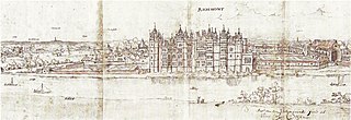
Richmond Palace was a Tudor royal residence on the River Thames in England which stood in the sixteenth and seventeenth centuries. Situated in what was then rural Surrey, it lay upstream and on the opposite bank from the Palace of Westminster, which was located nine miles (14 km) to the north-east. It was erected in about 1501 by Henry VII of England, formerly known as the Earl of Richmond, in honour of which the manor of Sheen had recently been renamed "Richmond". Richmond Palace therefore replaced Shene Palace, the latter palace being itself built on the site of an earlier manor house which had been appropriated by Edward I in 1299 and which was subsequently used by his next three direct descendants before it fell into disrepair.

<span class="mw-page-title-main">Richmond Green</span> Park in Richmond, London, England

Richmond Green is a recreation area near the centre of Richmond, a town of about 20,000 inhabitants situated in south-west London. Owned by the Crown Estate, it is leased to the London Borough of Richmond upon Thames. The Green, which has been described as "one of the most beautiful urban greens surviving anywhere in England", is roughly square in shape and its open grassland, framed with broadleaf trees, extends to roughly twelve acres. On the north-east side there is also a smaller open space called Little Green. Richmond Green and Little Green are overlooked by a mixture of period townhouses, historic buildings and municipal and commercial establishments including the Richmond Lending Library and Richmond Theatre.

<span class="mw-page-title-main">Glover's Island</span> Island in the River Thames in England

Glover's Island is a small island in a tree-lined section of the Thames River, formerly known as Horse Reach on the tidal Thames, between Richmond Lock and Teddington Lock in the Borough of Richmond upon Thames, London, England.

<span class="mw-page-title-main">Wick House, Richmond Hill</span> Grade II listed house in London, England

Wick House is a Grade II listed house in Petersham, London, located near the corner of Nightingale Lane and Richmond Hill. The painter Sir Joshua Reynolds commissioned the house from Sir William Chambers and it was completed in 1772.

<span class="mw-page-title-main">Sudbrook Park, Petersham</span> House and Park in Petersham, London

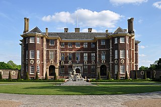
Sudbrook Park in Petersham was developed by John Campbell, 2nd Duke of Argyll in the early 18th century. Sudbrook House, designed for Argyll by James Gibbs and now Grade I listed by Historic England, is considered a fine example of Palladian architecture. The house and its surrounding park have been the home of the Richmond Golf Club since 1891.

<span class="mw-page-title-main">Hickey's Almshouses</span> Building in England, UK

Hickey's Almshouses are almshouses between Sheen Road and St Mary's Grove in Richmond, London.

<span class="mw-page-title-main">Queen Elizabeth's Almshouses, Richmond</span> Almshouses in Richmond, southwest London

Queen Elizabeth's Almhouses are almshouses in Richmond, London, founded by Sir George Wright in 1600 to house eight poor aged women. Known originally as the "lower almshouses", they were built in Petersham Road, a few hundred yards south of what is now Bridge Street. By 1767, they were almost derelict. In 1767, William Turner rebuilt the almshouses on land at the top end of his estate in The Vineyard. Funds for the rebuilding were raised by public subscription. The almshouses were rebuilt again in 1857. They were damaged during World War II and replaced with four newly built houses in 1955.

Halford House is a Grade II listed building in Halford Road, in the centre of Richmond in the London Borough of Richmond upon Thames. Originally an 18th-century manor house with 19th-century additions, it was purchased by the Christian Fellowship in Richmond in 1954. It previously housed the Richmond School of Music.

<span class="mw-page-title-main">Clarence House, Richmond</span> Residential in Richmond, London

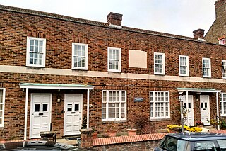
Clarence House, Richmond is a Grade II listed house in The Vineyard, Richmond, dating from about 1696.

<span class="mw-page-title-main">Ham Common, London</span> Common land in London

Ham Common is an area of common land in Ham, London. It is a conservation area in, and managed by, the London Borough of Richmond upon Thames. It comprises 48.69 hectares, the second largest area of common land in the borough, 2 acres (0.81 ha) smaller than Barnes Common. It is divided into two distinct habitats, grassland and woodland, separated by the A307, Upper Ham Road. It is an area of ecological, historical and recreational interest, designated a Local Nature Reserve.

<span class="mw-page-title-main">Bishop Duppa's Almshouses, Richmond</span> Historic site in London, England

Bishop Duppa's Almshouses, Richmond are Grade II listed almshouses in Richmond, London. They were founded by Brian Duppa, Bishop of Winchester, in 1661 to house ten unmarried women aged over 50.

<span class="mw-page-title-main">Vineyard Passage Burial Ground</span> Cemetery in Richmond upon Thames, London

Vineyard Passage Burial Ground is a cemetery on Vineyard Passage in Richmond in the London Borough of Richmond upon Thames. Established in 1790 and consecrated in 1791, it was enlarged in 1823. The last burials were in 1874. Managed by Richmond upon Thames Council and maintained by volunteers from the Environment Trust for Richmond upon Thames, it is now a garden of rest.

<span class="mw-page-title-main">The Vineyard, Richmond</span>

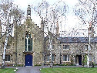
The Vineyard is a street in Richmond, in the London Borough of Richmond upon Thames. It includes three groups of almshouses, a Grade II listed church and Clarence House, a 17th-century Grade II listed house associated with Bernardo O’Higgins, who is commemorated on the wall of the property with a blue plaque, installed by English Heritage, for his role in the Chilean War of Independence.

References

  1. Warde-Aldam, Digby (15 September 2013). "Revolutionary Richmond?". Apollo . Retrieved 4 December 2014.
  2. "Turner & Constable & their Contemporaries: Sketching from Nature". Forthcoming events and exhibitions at the Laing. Laing Art Gallery. 2014. Archived from the original on 3 April 2014. Retrieved 4 December 2014.
  3. Jackson, Hazelle. "To Tree or not to Tree". London Gardens Trust . Retrieved 10 February 2024.
  4. Historic England. "TERRACE AND BUCCLEUCH GARDENS, Non Civil Parish (1001551)". National Heritage List for England . Retrieved 6 December 2021.
  5. "Terrace Gardens". London Borough of Richmond upon Thames. Retrieved 6 December 2021.
  6. 1 2 Richmond Hill Conservation Area 5 - London Borough of Richmond-upon-Thames.
  7. Orr, Stephen. "Clarence House". The Vineyard, Richmond. Retrieved 7 May 2013.
  8. Orr, Stephen. "Halford House". The Vineyard, Richmond. Retrieved 7 May 2013.
  9. Orr, Stephen. "Michel's Almshouses". The Vineyard, Richmond. Retrieved 7 May 2013.
  10. "Richmond", in Encyclopædia Britannica , (9th edition, 1881), s.v.
  11. Gover, J. E. B.; Mawer, A.; Stenton, F. M. (1934). The Place-Names of Surrey. English Place-Name Society. Vol. 11. Cambridge: Cambridge University Press. pp. 65–66.

Further reading

51°27′10″N0°17′57″W / 51.45278°N 0.29917°W / 51.45278; -0.29917