The East London line is part of the London Overground, running north to south through the East, Docklands and South areas of London. It was previously a line of the London Underground.

Whitechapel is an interchange station in Whitechapel, East London for London Underground, London Overground and Elizabeth line services. The station is located behind a street market of the same name and opposite Tower Hamlets Town Hall. It lies between Aldgate East and Stepney Green stations on the District and Hammersmith & City lines, between Shoreditch High Street and Shadwell stations on the East London Line. To the West of Whitechapel on the Elizabeth Line is Liverpool Street, to the East the line splits with one branch going to Stratford and one to Canary Wharf. It is in Travelcard Zone 2.

Wapping is a station on the London overground located on the northern bank of the River Thames in Wapping within the London Borough of Tower Hamlets. The station is served by National Rail London Overground services under the control of the London Rail division of Transport for London, however there is no standard red National Rail "double arrow" logo signage located at the station, instead only the Overground roundel. The station is between Shadwell and Rotherhithe, and is in Travelcard Zone 2.

Rotherhithe is a station on the East London Line located on the southern bank of the River Thames at Rotherhithe within the London Borough of Southwark, Greater London and is served by London Overground services. The station is between Wapping and Canada Water, and is in fare zone 2. The station re-opened for a preview service on 27 April 2010 to New Cross / New Cross Gate and 23 May 2010 for full service to New Cross / West Croydon / Crystal Palace. On 9 December 2012, the line was extended to serve Clapham Junction via Peckham Rye.

Surrey Quays is a station on the East London Line of the London Overground. It is located in Rotherhithe, part of London Borough of Southwark; it is in Zone 2. The next station to the north is Canada Water; to the south, it splits into branches to Clapham Junction, New Cross and Crystal Palace/West Croydon. Closed in late 2007 as an underground station, it was refurbished and reopened as part of the London Overground network on 27 April 2010.

New Cross Gate is a railway station in New Cross, London, on the Brighton Main Line and the London Overground. It is 2 miles 70 chains down the line from London Bridge and is about 600 m (660 yd) west of New Cross station. It is in Travelcard Zone 2, and is operated by London Overground.
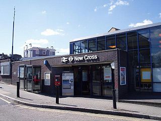
New Cross railway station serves New Cross in south-east London, England. It is 4 miles 68 chains (7.8 km) down the line from London Charing Cross and is in London fare zone 2. The platforms are lettered rather than numbered to avoid confusion with those at New Cross Gate by staff who worked at both stations before privatisation of the stations in 1997. Platform D is used exclusively by London Overground services. Ticket barriers control access to all platforms.
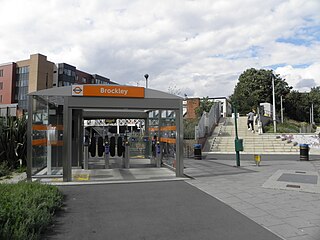
Brockley railway station serves the south-east London district of Brockley and is on the main railway line between London Bridge and Brighton. It is 3 miles 56 chains down the line from London Bridge.

Peckham Rye is a railway station in Peckham town centre, South London. The station is served by Southern, London Overground, Southeastern and Thameslink.

Queens Road Peckham railway station is in the London Borough of Southwark and also serves the area to the east of Peckham, in the London Borough of Lewisham. It is on the South London Line, 2 miles 58 chains (4.4 km) from London Bridge, and trains also go to Croydon via various routes and beyond. It is on the road of that name and is in Travelcard Zone 2.

Honor Oak Park railway station serves the suburban area of Honor Oak in the London Borough of Lewisham. It is 4 miles 59 chains down the line from London Bridge, between Brockley and Forest Hill.

Hackney Central is a London Overground station on the North London line in Hackney Central, north-east London. It lies between Dalston Kingsland and Homerton and is in Travelcard Zone 2. The station and all trains serving it are operated by London Overground services which are managed by Transport for London.

West Croydon is a combined railway, bus station and tram stop in Croydon, south London. It is served by National Rail, London Overground, Tramlink and London Buses services and is in Travelcard Zone 5.

Sydenham is a railway station in Sydenham in the London Borough of Lewisham, South London. Originally opened in 1839, the station is located on the former Croydon Canal, which is now a branch of the Brighton Main Line, often known as the Sydenham Corridor. Sydenham falls within Travelcard Zone 3 and is served by London Overground and Southern. The station is 6 miles 32 chains down the line from London Bridge.

Penge West railway station is located in Penge, a district of the London Borough of Bromley in south London. The station is operated by London Overground, with Overground and Southern trains serving the station. Thameslink and some Southern services pass through the station. It is 7 miles 15 chains down the line from London Bridge, in Travelcard Zone 4.

Dalston Junction is an inter-modal rail and bus transport interchange in Dalston, London. It is located at the crossroads of Dalston Lane, Kingsland Road and Balls Pond Road. The station served by London Overground East London line and is in Zone 2. The station is located in a short section of cut and cover tunnel north of the Kingsland Viaduct.

Shoreditch High Street is a London Overground station located on Bethnal Green Road in Shoreditch in East London. It is served by the East London Line between Whitechapel and Hoxton with services running either to Dalston Junction, Highbury & Islington or New Cross, New Cross Gate, West Croydon, Crystal Palace, and is in Travelcard Zone 1.

Hoxton is a station on the East London line in the London Borough of Hackney, Greater London. It is on the Kingsland Viaduct and served by London Overground. The station entrance is on Geffrye Street near Dunloe Street and Cremer Street, behind the Museum of the Home.

Haggerston is a London Overground station in Haggerston, London, England, served by the East London line. It lies between Hoxton and Dalston Junction stations, is in Travelcard Zone 2, and is open 24 hours on a Friday and Saturday as part of the London Overground Night Service service. The station was rebuilt as part of the East London line extension.
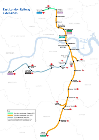
The East London line extension (ELLX) project was a British railway engineering project in London, managed by Transport for London. The project involved extending the East London Line and making it part of the mainline London Overground network. This was done by re-opening sections of disused railway line and by converting track electrified by the third-rail system, signalling, lineside signage and communication systems, etc. to mainline standards. New rolling stock was introduced and four new stations built along the route, with a fifth scheduled to be added in the future at New Bermondsey.