
Shropshire is a landlocked ceremonial county in the West Midlands of England, on the Welsh border. It is bordered by Wrexham County Borough and Cheshire to the north, Staffordshire to the east, Worcestershire to the south-east, Herefordshire to the south and Powys to the west. The largest settlement is Telford and Shrewsbury is the county town.

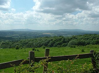
The Long Mynd is a heath and moorland plateau that forms part of the Shropshire Hills in Shropshire, England. The high ground, which is common land and designated as an Area of Outstanding Natural Beauty, lies between the Stiperstones range to the west and the Stretton Hills and Wenlock Edge to the east. Much of it is owned by the National Trust, and is managed by the Longmynd Commoners.

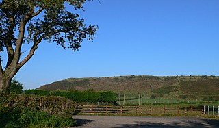
The Stiperstones is a distinctive hill in Shropshire, England. The quartzite rock of the ridge formed some 480 million years ago. During the last Ice Age Stiperstones lay on the eastern margin of the Welsh ice sheet. The hill itself was not glaciated though glaciers occupied surrounding valleys and it was subject to intense freezing and thawing which shattered the quartzite into a mass of jumbled scree surrounding several residual rocky tors. At 536 metres (1,759 ft) above sea level it is the second-highest hill in the county, surpassed only by Brown Clee Hill. Stiperstones' 8-kilometre (5 mi) summit ridge is crowned by several jagged outcrops of rock, which may be seen silhouetted against the sky.
The Shropshire Hills is a designated Area of Outstanding Natural Beauty (AONB) in Shropshire, England. It is located in the south of the county, extending to its border with Wales. Designated in 1958, the area encompasses 802 square kilometres (310 sq mi) of land primarily in south-west Shropshire, taking its name from the upland region of the Shropshire Hills. The A49 road and Welsh Marches Railway Line bisect the area north–south, passing through or near Shrewsbury, Church Stretton, Craven Arms and Ludlow.
The geology of Shropshire is very diverse with a large number of periods being represented at outcrop. The bedrock consists principally of sedimentary rocks of Palaeozoic and Mesozoic age, surrounding restricted areas of Precambrian metasedimentary and metavolcanic rocks. The county hosts in its Quaternary deposits and landforms, a significant record of recent glaciation. The exploitation of the Coal Measures and other Carboniferous age strata in the Ironbridge area made it one of the birthplaces of the Industrial Revolution. There is also a large amount of mineral wealth in the county, including lead and baryte. Quarrying is still active, with limestone for cement manufacture and concrete aggregate, sandstone, greywacke and dolerite for road aggregate, and sand and gravel for aggregate and drainage filters. Groundwater is an equally important economic resource.
The Clee Hills are a range of hills in Shropshire, England near Ludlow, consisting of Brown Clee Hill 1,772 feet (540 m), the highest peak in Shropshire, and Titterstone Clee Hill 1,749 feet (533 m). They are both in the Shropshire Hills Area of Outstanding Natural Beauty.

Caer Caradoc is a hill in the English county of Shropshire. It overlooks the town of Church Stretton and the village of All Stretton and offers panoramic views to the north towards the Wrekin, east to Wenlock Edge, and west over the nearby Long Mynd. It is not to be confused with another hillfort of the same name 1 km west of Chapel Lawn near Bucknell.
Shatterford Hill is an English geographical feature that extends from Bewdley in north Worcestershire to Birdsgreen near Alveley, just over the border in Shropshire. The hill is a long ridge running up the east side of the Severn Valley and peaks at 202 metres near the village of Shatterford on the A442 road between Kidderminster and Bridgnorth.

The Dorset Heaths form an important area of heathland within the Poole Basin in southern England. Much of the area is protected.
The Natural Areas of England are regions, officially designated by Natural England, each with a characteristic association of wildlife and natural features. More formally, they are defined as "biogeographic zones which reflect the geological foundation, the natural systems and processes and the wildlife in different parts of England...".
The Oswestry Uplands are a small natural region in the English county of Shropshire on the border with Wales.

The Thames Basin Heaths are a natural region in southern England in Berkshire, Hampshire and Surrey, a slightly mottled east-west belt of ecologically recognised and protected land.

The Marshwood and Powerstock Vales form a natural region in southwest England reaching to the Dorset coastline.

The Yeovil Scarplands are a natural region in southern England in the counties of Somerset and Dorset.

The Mid Somerset Hills are a major natural region in the county of Somerset in southwest west England, forming a series of low hills and ridges that divide up the Somerset Levels.

The North Northumberland Coastal Plain is a major natural region that lies on England's northeasternmost stretch of coastline on the North Sea. To the west lie the Cheviot Fringe, the Northumberland Sandstone Hills and Mid Northumberland; to the south it is continued by the South East Northumberland Coastal Plain.

The Northumberland Sandstone Hills are a major natural region in the English county of Northumberland. The hills form distinctive skylines with generally level tops, northwest facing scarps and craggy outcrops offering views to the Cheviots further west.

The Mid Severn Sandstone Plateau is a rural landscape and one of the natural regions of central England, straddling the border between the counties of Shropshire and Staffordshire. It stretches from the western fringes of the Birmingham conurbation to Telford in the north and Kidderminster in the south. The major feature of the plateau is the valley of the River Severn, which cuts through it from north to south. It consists of Permian and Triassic-age New Red Sandstone getting older as one goes west until one reaches Silurian and Carboniferous-age siltstones and coals west of the river.
