South Woodford tube station

Last updated

South Woodford Underground no-text.svg
South Woodford entrance west.JPG
Western entrance on George Lane
Greater London UK location map 2.svg
Red pog.svg
South Woodford
Location of South Woodford in Greater London
Location South Woodford
Local authority London Borough of Redbridge
Managed by London Underground
Number of platforms2
AccessibleYes [1]
Fare zone 4
London Underground annual entry and exit
2018Increase2.svg 5.34 million [2]
2019Decrease2.svg 5.27 million [3]
2020Decrease2.svg 2.31 million [4]
2021Increase2.svg 2.38 million [5]
2022Increase2.svg 3.79 million [6]
Railway companies
Original company Eastern Counties Railway
Pre-grouping Great Eastern Railway
Post-grouping London and North Eastern Railway
Key dates
22 August 1856 (1856-08-22)Opened as George Lane
5 July 1937Renamed South Woodford (George Lane)
14 December 1947Central line service introduced; renamed South Woodford
1964Goods yard closed [7]
Other information
External links
WGS84 51°35′30″N0°01′39″E / 51.5916°N 0.0275°E / 51.5916; 0.0275
Underground sign at Westminster.jpg  London transportportal

South Woodford, originally George Lane, is a London Underground station in the suburb of South Woodford in East London. It is on the Epping branch of the Central line, between Snaresbrook and Woodford stations and is in Travelcard Zone 4. [8]

Contents

History

Roundel on the eastbound platform, showing the old suffix. South Woodford stn roundel.JPG
Roundel on the eastbound platform, showing the old suffix.

The station opened on 22 August 1856 as part of the Eastern Counties Railway branch to Loughton which opened that day. [9] [10] [11] Originally named George Lane, the station was renamed twice: South Woodford (George Lane) on 5 July 1937; and South Woodford on 14 December 1947. [12] The station formed part of the Great Eastern Railway's system until that company amalgamated with other railways to create the London and North Eastern Railway (LNER) in 1923. On 5 July 1937 the station was renamed "South Woodford (George Lane)". [9] [13]

The station was subsequently transferred to form part of London Underground's Central line on 14 December 1947 when Central line services were extended from Leytonstone to Woodford. [14] This formed a part of the long planned, and delayed, Eastern Extension of the Central line that was part of the London Passenger Transport Board's "New Works Programme" of 1935 – 1940. After transferring to London Underground the "(George Lane)" suffix fell out of use, though it remains on some roundel signs. [15] [note 1]

During the planning of the Victoria line, route options included a continuation of the line from Walthamstow Central to Woodford or South Woodford stations. [16] However, in 1961, the decision was taken to build only as far as Walthamstow Central. [17]

The station today

The station has two entrances, one on each side of the line. George Lane originally crossed the railway tracks with a level crossing immediately to the north of the station, but this was closed and the road split into two when the line was electrified. [18] The footbridge can be used without a ticket as, unusually for stations on the Epping branch, the footbridge is outside the ticket gateline. [19] For some years the station had step-free access to and from the eastbound platform only. [1] The ramp to the westbound platform was installed and opened in March 2019, making the station fully step-free. [20]

Station improvements

The station underwent considerable renovations in 2006, 150 years after it opened. Five new CCTV cameras were installed in the station underpass with the intention of improving security as, in addition to the multimillion-pound station refurbishment work being undertaken, crime statistics showed South Woodford station had the highest record of violent crime in Redbridge and the underpass was seen as a security risk, particularly after dark. [21] The rebuilding of the section of westbound platform damaged by fire was also completed and the paint scheme was a mix of white, blue and orange. However, the footbridge over the tracks at the east end was not repainted. [22]

Services and connections

Train frequencies vary throughout the day, but generally operate every 3–7 minutes between 07:03 and 22:39 eastbound [23] and between 06:22 and 22:19 westbound. [24]

London Bus routes 179, 549, W12, W13 and W14, and night route N55 serve the station. [25]

Preceding station Underground no-text.svg London Underground Following station
Snaresbrook Central line
Epping branch
Woodford
towards Epping
Historical railways
Snaresbrook
Line and station open
  Great Eastern Railway
Eastern Counties Railway
Loughton branch
  Woodford
Line and station open

Notes and references

Notes

  1. "(George Lane)" appears on the 1949 tube map, but not on the 1951 map. Harris and Rose both indicate that the name change occurred in 1950. [13] [14]

Related Research Articles

<span class="mw-page-title-main">Kilburn tube station</span> London Underground station

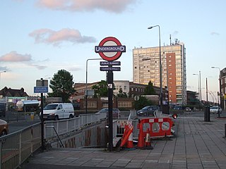
Kilburn is a London Underground station near Brondesbury Park in north-west London. It is on the Jubilee line, between Willesden Green and West Hampstead stations and is in Travelcard Zone 2. The station is on the A5 Kilburn High Road or Shoot-up Hill, approximately 0.1 miles (0.16 km) north of Brondesbury station. Metropolitan line trains typically bypass the station without stopping.

<span class="mw-page-title-main">West Hampstead tube station</span> London Underground station

West Hampstead is a London Underground station in West Hampstead. It is located on West End Lane between Broadhurst Gardens and Blackburn Road and is situated in Travelcard Zone 2. It is on the Jubilee line between Kilburn and Finchley Road stations. It is 100 m (110 yd) from West Hampstead station on the London Overground North London line and 200 m (220 yd) from West Hampstead Thameslink station. Metropolitan line trains also pass through the station, but do not usually stop.

<span class="mw-page-title-main">Chancery Lane tube station</span> London Underground station

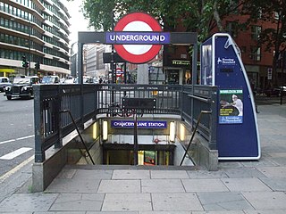
Chancery Lane is a London Underground station on the Central Line between Holborn and The City in Central London, England. It has entrances within both the London Borough of Camden and the City of London. It opened in 1900 and takes its name from the nearby Chancery Lane.

<span class="mw-page-title-main">Leyton tube station</span> London Underground station

Leyton is a London Underground station in Leyton, in the London Borough of Waltham Forest, East London. Located on Leyton High Road, adjacent to the A12, the station is on the Central line between two stations assigned to two fare zones – Stratford and Leytonstone. It is in zone 3.

<span class="mw-page-title-main">Woodford tube station</span> London Underground station

Woodford is a London Underground station in the town of Woodford in the London Borough of Redbridge, East London. The station is on the Central line, between South Woodford and Buckhurst Hill stations and is in Travelcard Zone 4. The station also acts as a terminus for services via the Hainault loop.

<span class="mw-page-title-main">Sudbury Hill tube station</span> London Underground station

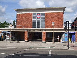
Sudbury Hill is a London Underground station on the Uxbridge branch of the Piccadilly line. The station is between Sudbury Town and South Harrow, and is in Travelcard Zone 4. It is located on Greenford Road (A4127) north of the junction with Whitton Avenue, on the border between the London Boroughs of Harrow and Ealing. The station is close to Sudbury Hill Harrow railway station.

<span class="mw-page-title-main">Alperton tube station</span> London Underground station

Alperton is a London Underground station on the Uxbridge branch of the Piccadilly line. The station is between Sudbury Town and Park Royal, in Travelcard Zone 4. It is located on Ealing Road (A4089), a short distance from the junction with Bridgewater Road (A4005), and is close to the Paddington branch of the Grand Union Canal. The station was refurbished in 2006.

<span class="mw-page-title-main">Ealing Common tube station</span> London Underground station

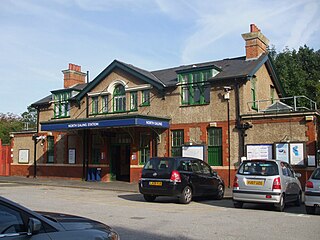
Ealing Common is a London Underground station on the Uxbridge branch of the Piccadilly line and on the Ealing Broadway branch of the District line. Eastbound, the next station is Acton Town; westbound, the next station is North Ealing on the Piccadilly line and Ealing Broadway on the District line. Here, the District and Piccadilly lines share the same pair of tracks through the station – the only other example where a deep level line and a sub surface line share the same pair of tracks is further up the Uxbridge branch, where the Piccadilly line shares tracks with the Metropolitan line from Rayners Lane to Uxbridge. It is the only station west of Acton Town to be served by both the Piccadilly and District lines.

<span class="mw-page-title-main">Boston Manor tube station</span> London Underground station

Boston Manor is a London Underground station at the boundary of the boroughs of Hounslow and Ealing. The station is situated on the Heathrow branch of the Piccadilly line, between Osterley and Northfields stations, in Travelcard Zone 4.

<span class="mw-page-title-main">Mill Hill East tube station</span> London Underground station

Mill Hill East is a London Underground station in Mill Hill in the London Borough of Barnet, north London. The station is the terminus and only station of a single-track branch of the Northern line from Finchley Central station and is in Travelcard Zone 4. It is the least used station on the Northern line with 1.41 million passengers in 2022.

<span class="mw-page-title-main">Blackhorse Road station</span> London Overground and London Underground station

Blackhorse Road is a joint London Overground and London Underground station, located at the junction of Blackhorse Road/Blackhorse Lane with Forest Road in Walthamstow, London, England. It is on the Victoria line of the London Underground and is the penultimate station on the eastern end of that line. Above ground, the station is on the Gospel Oak to Barking line of the London Overground, 7 miles 21 chains (11.7 km) from St Pancras.

<span class="mw-page-title-main">Leytonstone tube station</span> London Underground station

Leytonstone is a London Underground station in Leytonstone in the London Borough of Waltham Forest, east London. It is on the Central line, on the boundary of Zones 3 and 4. Towards Central London, the next station is Leyton, while going east from Leytonstone, the line divides into two branches. On the direct route to Woodford and Epping the next stop is Snaresbrook, and on the Hainault loop it is Wanstead. The station is close to Whipps Cross University Hospital. It is a terminus for some services and returns westbound.

<span class="mw-page-title-main">Buckhurst Hill tube station</span> London Underground station

Buckhurst Hill is a London Underground station, in the Epping Forest district of Essex. It is served by the Central line and is between Woodford and Loughton. It is the larger of the two Underground stations in the town of Buckhurst Hill, with Roding Valley station being the smaller. It is the only London Underground station located in Zone 5 but not in a London Borough.

<span class="mw-page-title-main">Finchley Central tube station</span> London Underground station

Finchley Central is a London Underground station in the Church End area of Finchley, north London. The station is located on the High Barnet branch of the Northern line, between West Finchley and East Finchley stations; it is the junction for the short branch to Mill Hill East. The station is around 7 miles north-northwest of Charing Cross and is in Travelcard Zone 4.

<span class="mw-page-title-main">Snaresbrook tube station</span> London Underground station

Snaresbrook is a London Underground station on the Central line, located in the area of Snaresbrook in East London. The station is in Zone 4, between Leytonstone and South Woodford stations.

<span class="mw-page-title-main">Gants Hill tube station</span> London Underground station

Gants Hill is a London Underground station in the largely residential Gants Hill district of Ilford in East London. It is served by the Central line and is between Redbridge and Newbury Park stations on the Hainault loop. It is in Travelcard Zone 4. It is the easternmost station to be below ground on the London Underground network and the busiest on the Hainault loop.

<span class="mw-page-title-main">East Acton tube station</span> London Underground station

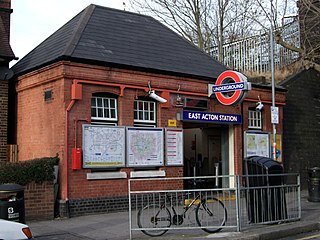
East Acton is a London Underground station in East Acton in London Borough of Hammersmith and Fulham. The station is on the Central line, between White City and North Acton stations, and in Travelcard Zone 2. Wormwood Scrubs, Queen Charlotte's and Chelsea Hospital, Hammersmith Hospital, Wormwood Scrubs prison and Imperial College Hammersmith branch are accessible from the station.

<span class="mw-page-title-main">North Ealing tube station</span> London Underground station

North Ealing is a London Underground station on the Uxbridge branch of the Piccadilly line between Ealing Common and Park Royal. The station is located on Station Road, a short distance from the junction of Queen's Drive and Hanger Lane. It is in Travelcard Zone 3. West Acton station on the Central line is located about 550 metres to the east at the other end of Queen's Drive.

<span class="mw-page-title-main">Newbury Park tube station</span> London Underground station

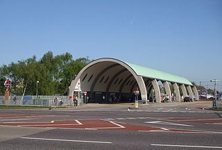
Newbury Park is a London Underground station in Newbury Park, Ilford, East London. It is between Barkingside and Gants Hill stations on the Hainault loop of the Central line, in Travelcard Zone 4. The station was initially opened by the Great Eastern Railway on 1 May 1903 and subsequently transferred its services to the London & North Eastern Railway due to the amalgamation. Underground trains only started serving the station on 14 December 1947, operating via the Gants Hill tunnel. The line was extended to Hainault on 31 May 1948. The Grade II listed bus shelter designed by Oliver Hill opened on 6 July 1949. Lifts were fully installed at Newbury Park in November 2018 to provide step-free access to the station, approximately 10 years after TfL abandoned the project.

<span class="mw-page-title-main">Debden tube station</span> London Underground station

Debden is a London Underground station on the Central line in the east of Loughton, in the Epping Forest district of Essex. The station is between Loughton and Theydon Bois. It is located in Station Approach off Chigwell Lane (A1168) and is in Travelcard Zone 6.

References

  1. 1 2 "Step free Tube Guide" (PDF). Transport for London . April 2021. Archived (PDF) from the original on 15 May 2021.
  2. "Station Usage Data" (CSV). Usage Statistics for London Stations, 2018. Transport for London. 23 September 2020. Archived from the original on 14 January 2023. Retrieved 11 October 2023.
  3. "Station Usage Data" (XLSX). Usage Statistics for London Stations, 2019. Transport for London. 23 September 2020. Archived from the original on 9 November 2020. Retrieved 9 November 2020.
  4. "Station Usage Data" (XLSX). Usage Statistics for London Stations, 2020. Transport for London. 16 April 2021. Retrieved 1 January 2022.
  5. "Station Usage Data" (XLSX). Usage Statistics for London Stations, 2021. Transport for London. 12 July 2022. Retrieved 7 September 2022.
  6. "Station Usage Data" (XLSX). Usage Statistics for London Stations, 2022. Transport for London. 4 October 2023. Retrieved 10 October 2023.
  7. Hardy, Brian, ed. (March 2011). "How it used to be – freight on The Underground 50 years ago". Underground News. London Underground Railway Society (591): 175–183. ISSN   0306-8617.
  8. Standard Tube Map (PDF) (Map). Not to scale. Transport for London. November 2022. Archived (PDF) from the original on 7 November 2022. Retrieved 12 November 2022.
  9. 1 2 Leboff 1994, p. 127.
  10. Butt 1995, p. 102.
  11. Allen 1956, pp. 20, 216.
  12. Butt 1995, pp. 102, 217.
  13. 1 2 Harris, Cyril M. (2006) [1977]. What's in a name?. Capital Transport. p. 64. ISBN   1-85414-241-0.
  14. 1 2 Rose, Douglas (1999) [1980]. The London Underground, A Diagrammatic History (7th ed.). Douglas Rose/Capital Transport. ISBN   1-85414-219-4.
  15. "Tube Facts – Tube Stations with other/alternative names". Archived from the original on 1 May 2015. Retrieved 16 February 2015.
  16. "Public Passenger Transport, London". Parliamentary Debates (Hansard) . 18 December 1963.
  17. Horne, M.A.C. (1988). The Victoria Line: A short history. London: Douglas Rose. ISBN   978-1-870354-02-8.
  18. Powell, W. R., ed. (1973). "Woodford: Introduction". A History of the County of Essex. Vol. 6. Victoria County History. pp. 338–44.
  19. "South Woodford tube station" (Map). Google Maps. Retrieved 19 March 2019.
  20. "South Woodford Tube station becomes fully step-free". Transport for London. 18 March 2019. Retrieved 18 March 2019.
  21. Edited Press Releases Transport for London London Underground – Metronet improves security at South Woodford (page 7)
  22. "Station Refurbishment Summary" (PDF). London Underground Railway Society. July 2007. Retrieved 19 February 2015.
  23. "Central line timetable: From South Woodford Underground Station to Woodford Underground Station". Transport for London . Retrieved 20 February 2015.
  24. "Central line timetable: From South Woodford Underground Station to Snaresbrook Underground Station". Transport for London . Retrieved 20 February 2015.
  25. "Buses from South Woodford" (PDF). Transport for London . 20 October 2013. Retrieved 20 February 2015.

Bibliography