Southwark tube station

Last updated

Southwark Underground no-text.svg
Southwarktubestation.JPG
Entrance on The Cut
Open street map central london.svg
Red pog.svg
Southwark
Location of Southwark in Central London
Location Bankside
Local authority London Borough of Southwark
Managed by London Underground
Number of platforms2
AccessibleYes [1]
Fare zone 1
OSI Waterloo East National Rail logo.svg
Blackfriars at Bankside entrance National Rail logo.svg [2]
London Underground annual entry and exit
2018Decrease2.svg 15.33 million [3]
2019Decrease2.svg 14.95 million [4]
2020Decrease2.svg 3.57 million [5]
2021Increase2.svg 5.03 million [6]
2022Increase2.svg 8.92 million [7]
Railway companies
Original company London Regional Transport
Key dates
20 November 1999Opened
Other information
External links
WGS84 51°30′14″N0°06′18″W / 51.5039°N 0.105°W / 51.5039; -0.105
Underground sign at Westminster.jpg  London transportportal

Southwark is a London Underground station in the London Borough of Southwark at the corner of Blackfriars Road and The Cut. It is between Waterloo and London Bridge stations on the Jubilee line, and is in Travelcard Zone 1. It was opened on 20 November 1999 as part of the Jubilee Line Extension. [8] The station is somewhat west of historic Southwark, which is served by Borough and London Bridge stations. Its entrance is across the road from the disused Blackfriars Road railway station.

Contents

History

The original plan for the Jubilee Line Extension did not include a station between those at Waterloo and London Bridge; Southwark station was added after lobbying by the local council as well as North Southwark and Bermondsey MP Simon Hughes. [9] [10]

The architects MacCormac, Jamieson, Prichard were appointed in January 1991 by the Jubilee Line Extension design team led by Roland Paoletti. [11] Planning approval for the station was given in 1992, [12] with the contract to built the station and adjacent tunnels awarded to a joint venture of Aoki Corporation and Soletanche in November 1993 at a cost of £64 million. [13] [14] Construction began in 1994, with tunnelling beginning in April 1995. [14] [15]

Built on a cramped site, with its platforms underneath the Victorian main line viaduct between Waterloo East and London Bridge stations, the station presented significant technical and architectural difficulties which were resolved by constructing two concourses at different levels. [13] [14] Substantial compensation grouting was required to stablise the railway viaducts. [13] The station opened with the final phase of the Jubilee Line Extension on 20 November 1999. [16]

Although it is close to Waterloo, not near the Bankside attractions it was intended to serve, and its only National Rail interchange is to London Waterloo East main line station; the passenger usage matches those of other minor central stations. It does however get over twice the traffic of nearby Borough station, and around three times that of Lambeth North. [9]

Design

The station was designed by Sir Richard MacCormac of MacCormac, Jamieson, Prichard. [10] Jubilee Line Extension project director Hugh Doherty called the station a "remarkable feat of engineering". [11]

The upper concourse is the centrepiece of the station. It is a space 16 metres (52 ft) high with a glass roof that allows daylight to enter deep into the station. [17] It is faced with a spectacular glass wall, 40 metres (130 ft) long, consisting of 660 specially cut pieces of blue glass, which was designed by the artist Alexander Beleschenko. [15] MacCormac said the design of this and the lower concourse was inspired by a stage set design by 19th-century Prussian architect Karl Friedrich Schinkel for The Magic Flute. [15] The wall is one of the extension's more celebrated architectural features, winning critical approval and a number of awards.

The two platforms have platform screen doors which are meant to prevent passengers or debris from falling onto the tracks. They are connected at each end to the lower concourse which is a simple tunnel between the platforms and is illuminated by glass and steel "beacons" at each end, and is faced with stainless steel panels, deliberately left unpolished. [18] Stairs lead up to a section of high floor in the central area of the tunnel, from where three narrow tube-like escalator shafts lead sideways (south) to the higher concourse. [10]

One end of the higher concourse connects to Waterloo East station, and the other end to the station's modest low-rise entrance building which is intended as a base for a future commercial development. [10]

In 2000, the station was awarded a Royal Institute of British Architects Bronze medal, as well as being named Royal Fine Arts Commission/British Sky Broadcasting Building of the Year. [18]

Connections

London Buses routes 40, 63 and night routes N63 and N89 serve the station. [19] [20]

Additional images of Southwark Underground Station, and an architectural case study, are available on the Commission for Architecture and the Built Environment (CABE) web site. [21]

Nearby sights

Related Research Articles

<span class="mw-page-title-main">Waterloo tube station</span> London Underground station

Waterloo is a London Underground station located beneath Waterloo National Rail station. As of 2022, it is the 2nd busiest station on the London Underground, with 68.72 million users. It is served by four lines: the Bakerloo, Jubilee, Northern and Waterloo & City lines.

<span class="mw-page-title-main">London Bridge station</span> London Underground and mainline railway station

London Bridge is a central London railway terminus and connected London Underground station in Southwark, south-east London. It occupies a large area on three levels immediately south-east of London Bridge, from which it takes its name. The main line station is the oldest railway station in London fare zone 1 and one of the oldest in the world having opened in 1836. It is one of two main line termini in London to the south of the River Thames and is the fourth-busiest station in London, handling over 50 million passengers a year.

<span class="mw-page-title-main">Embankment tube station</span> London Underground station

Embankment is a London Underground station in the City of Westminster, known by various names during its history. It is served by the Circle, District, Northern and Bakerloo lines. On the Bakerloo line and the Charing Cross branch of the Northern line, the station is between Waterloo and Charing Cross stations; on the Circle and District lines, it is between Westminster and Temple and is in Travelcard Zone 1. The station has two entrances, one on Victoria Embankment and the other on Villiers Street. The station is adjacent to Victoria Embankment Gardens and is close to Charing Cross station, Embankment Pier, Hungerford Bridge, Cleopatra's Needle, the Royal Air Force Memorial, the Savoy Chapel and Savoy Hotel and the Playhouse and New Players Theatres.

<span class="mw-page-title-main">Baker Street tube station</span> London Underground station

Baker Street is a London Underground station at the junction of Baker Street and the Marylebone Road in the City of Westminster. It is one of the original stations of the Metropolitan Railway (MR), the world's first underground railway, opened on 10 January 1863.

<span class="mw-page-title-main">Canary Wharf tube station</span> London Underground station

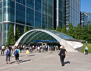
Canary Wharf is a London Underground station at Canary Wharf and is on the Jubilee line, between Canada Water and North Greenwich stations. The station is located in Travelcard Zone 2 and was opened on 17 September 1999 as part of the Jubilee Line Extension. Over 40 million people pass through the station each year, making it second busiest on the London Underground outside Central London after Stratford, and also the busiest that serves only a single line.

<span class="mw-page-title-main">North Greenwich tube station</span> London Underground station

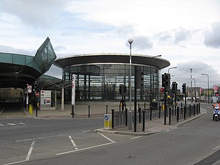
North Greenwich is a London Underground station served by the Jubilee line. Despite its name, it is not in the local area historically known as North Greenwich, on the Isle of Dogs, north of the River Thames; a completely different North Greenwich station used to be there, from 1872 until 1926. It is actually closer to Charlton than to Greenwich; however, it is at the northernmost tip of the Royal Borough of Greenwich, which perhaps gives the best explanation of the name.

<span class="mw-page-title-main">Elephant & Castle tube station</span> London Underground station

Elephant & Castle is a London Underground station in the London Borough of Southwark in south London. It is on the Bank branch of the Northern line between Kennington and Borough stations, and is the southern terminus of the Bakerloo line, the next station being Lambeth North. The station is in both Travelcard Zones 1 and 2. The Northern line station was opened in 1890 by the City and South London Railway (C&SLR) while the Bakerloo line station was opened sixteen years later by the Baker Street and Waterloo Railway (BS&WR). There is an out-of-station interchange with the nearby Elephant & Castle National Rail station.

<span class="mw-page-title-main">Westminster tube station</span> London Underground station

Westminster is a London Underground station in the City of Westminster. It is served by the Circle, District and Jubilee lines. On the Circle and District lines, the station is between St James's Park and Embankment, and on the Jubilee line it is between Green Park and Waterloo. It is in Travelcard Zone 1. The station is located at the corner of Bridge Street and Victoria Embankment and is close to the Houses of Parliament, Westminster Abbey, Parliament Square, Whitehall, Westminster Bridge, and the London Eye. Also close by are Downing Street, the Cenotaph, Westminster Millennium Pier, the Treasury, the Foreign and Commonwealth Office, and the Supreme Court.

<span class="mw-page-title-main">Bermondsey tube station</span> London Underground station

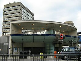
Bermondsey is a London Underground station. It is in the eastern part of Bermondsey in the London Borough of Southwark and also serves the western part of Rotherhithe, in south-east London.

<span class="mw-page-title-main">Canada Water station</span> London Underground and London Overground station

Canada Water is a London Underground and London Overground station located in Canada Water, in south London, England. It takes its name from Canada Water, a lake which was created from a former dock in the Port of London.

<span class="mw-page-title-main">Canning Town station</span> London Underground and Docklands Light Railway station

Canning Town is an interchange station located in Canning Town, London for London Underground, Docklands Light Railway (DLR) and London Buses services.

<span class="mw-page-title-main">West Ham station</span> London Underground, Docklands Light Railway and National rail station

West Ham is an interchange station in West Ham, London for London Underground, Docklands Light Railway (DLR) and National Rail services.

<span class="mw-page-title-main">Kennington tube station</span> London Underground station

Kennington is a London Underground station on Kennington Park Road in Kennington within the London Borough of Southwark. The station is at the junction of the Charing Cross and Bank branches of the Northern line to the north and the Morden and Battersea Power Station branches to the south. Its neighbouring stations to the north are Waterloo on the Charing Cross branch and Elephant & Castle on the Bank branch; the next stations to the south are Oval and Nine Elms. The station is in both Travelcard Zones 1 and 2.

<span class="mw-page-title-main">Blackfriars station</span> London Underground and railway station

Blackfriars, also known as London Blackfriars, is a central London railway station and connected London Underground station in the City of London. It provides Thameslink services: local, and regional and limited Southeastern commuter services to South East London and Kent. Its platforms span the River Thames, the only one in London to do so, along the length of Blackfriars Railway Bridge, a short distance downstream from Blackfriars Bridge. There are two station entrances either side of the Thames, along with a connection to the London Underground District and Circle lines.

<span class="mw-page-title-main">Vauxhall station</span> London Underground and railway station

Vauxhall is a National Rail, London Underground and London Buses interchange station in central London. It is at the Vauxhall Cross road junction opposite the southern approach to Vauxhall Bridge over the River Thames in the district of Vauxhall. The mainline station is run by the South Western Railway and is the first stop on the South West Main Line from London Waterloo towards Clapham Junction and the south-west. The Underground station is on the Victoria line and the station is close to St George Wharf Pier for river services.

<span class="mw-page-title-main">Waterloo East railway station</span> Railway station in central London

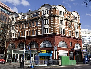
Waterloo East railway station, also known as London Waterloo East, is a railway station in central London on the line from Charing Cross through to London Bridge towards Kent, in the south-east of England. It is to the east of London Waterloo railway station and close to Southwark tube station.

<span class="mw-page-title-main">Jubilee Line Extension</span> London Underground extension

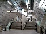
The Jubilee Line Extension (JLE) is the extension of the London Underground Jubilee line from Green Park to Stratford through south and east London. An eastward extension of the line was first proposed in the 1970s. As part of the development of London Docklands, the line was extended to serve Canary Wharf and other areas of south and east London. Construction began in 1993, and it opened in stages from May to December 1999, at a cost of £3.5 billion.

<span class="mw-page-title-main">South Harrow tube station</span> London Underground station

South Harrow is a London Underground station on the Uxbridge branch of the Piccadilly line. It is between Rayners Lane and Sudbury Hill stations. It is located on Northolt Road (A312). The station is in Travelcard Zone 5. There are several bus stands outside the station as well as overnight train stabling sidings.

Romano Roland Paoletti, CBE was a British-Italian architect. He was best known for his work on the early stations for Hong Kong's Mass Transit Railway, and for commissioning the award-winning designs of the stations of London Underground's Jubilee Line Extension. He was described by the Architectural Review as "the Medici of London Transport".

<span class="mw-page-title-main">Paddington tube station (Bakerloo, Circle and District lines)</span> London Underground station

Paddington is a London Underground station served by the Bakerloo, Circle and District lines. It is located on Praed Street to the south of Paddington mainline station and has entrances from Praed Street and from within the mainline station. On the Bakerloo line the station is between Warwick Avenue and Edgware Road and on the Circle and District lines it is between Bayswater and Edgware Road. It is in London Fare Zone 1.

References

  1. "Step free Tube Guide" (PDF). Transport for London . April 2021. Archived (PDF) from the original on 15 May 2021.
  2. "Out of Station Interchanges" (XLSX). Transport for London. 16 June 2020. Retrieved 5 November 2020.
  3. "Station Usage Data" (CSV). Usage Statistics for London Stations, 2018. Transport for London. 23 September 2020. Archived from the original on 14 January 2023. Retrieved 11 October 2023.
  4. "Station Usage Data" (XLSX). Usage Statistics for London Stations, 2019. Transport for London. 23 September 2020. Archived from the original on 9 November 2020. Retrieved 9 November 2020.
  5. "Station Usage Data" (XLSX). Usage Statistics for London Stations, 2020. Transport for London. 16 April 2021. Retrieved 1 January 2022.
  6. "Station Usage Data" (XLSX). Usage Statistics for London Stations, 2021. Transport for London. 12 July 2022. Retrieved 7 September 2022.
  7. "Station Usage Data" (XLSX). Usage Statistics for London Stations, 2022. Transport for London. 4 October 2023. Retrieved 10 October 2023.
  8. "The new JLE Station at Southwark opens". London Transport . 15 November 1999. Archived from the original on 3 March 2000. Retrieved 27 May 2020.
  9. 1 2 "The Jubilee Line Extension and Southwark Tube Station 10 years on". London SE1. 23 November 2009. Retrieved 19 February 2024.
  10. 1 2 3 4 Mitchell, Bob (2003). Jubilee Line Extension: From Concept to Completion. London: Thomas Telford Publishing. p. 161. ISBN   0727730282.
  11. 1 2 Mitchell, Bob (2003). Jubilee Line Extension: From Concept to Completion. London: Thomas Telford Publishing. ISBN   0727730282.
  12. "London Underground Act 1992 (c. iii) (c. 3)". Opsi.gov.uk. Retrieved 22 June 2010.
  13. 1 2 3 "Contract 103 Waterloo to London Bridge Running Tunnels, Southwark Station". Construction News. 21 September 1995. Retrieved 19 February 2024.
  14. 1 2 3 Mitchell, Bob (2003). Jubilee Line Extension: From Concept to Completion. London: Thomas Telford Publishing. pp. 210–212. ISBN   0727730282.
  15. 1 2 3 "Southwark Underground Station (design process) | Case Studies | CABE". Commission for Architecture and the Built Environment (CABE). 4 February 2009. Archived from the original on 4 February 2009. Retrieved 19 February 2024.
  16. "Jubilee Line finally opens". BBC News . 20 November 1999. Retrieved 24 March 2023.
  17. "UK Jubilee Line Extension (JLE)" (PDF). omegacentre.bartlett.ucl.ac.uk. Bartlett School of Planning. Retrieved 28 October 2016.
  18. 1 2 "Case Name: Southwark Underground Station" (PDF). Save Britain's Heritage . Historic England. 10 July 2017. Retrieved 19 February 2024.
  19. "Buses from Southwark" (PDF). TfL. June 2022. Retrieved 20 July 2022.
  20. "Southwark Underground Station". TfL. Retrieved 20 July 2022.
  21. "Southwark Underground Station (photos)". Commission for Architecture and the Built Environment (CABE). Archived from the original on 11 April 2008. Retrieved 1 March 2008.
Preceding station Underground no-text.svg London Underground Following station
Waterloo
towards Stanmore
Jubilee line London Bridge
towards Stratford