St. Lawrence is a neighbourhood located in downtown Toronto, Ontario, Canada. The area, a former industrial area, is bounded by Yonge, Front, and Parliament Streets, and the Canadian National railway embankment. The Esplanade off Yonge St., lined with restaurants, cafés and hotels runs through the middle of the area. In previous times, the area was sometimes referred to as 'St. Lawrence Ward' or more often today as 'St. Lawrence Market', synonymous with the large retail vendor market which is the neighbourhood's focal point. The area is the site of a large city-sponsored housing project of the 1970s, which revitalized an old 'brownfields' area. The boundaries of the St Lawrence Neighbourhood Association and the St Lawrence Market BIA are somewhat larger than those noted above. Both groups have boundaries that extend from Yonge to Parliament Streets and Queen Street East to the rail corridor.

Union Station is a major railway station and intermodal transportation hub in Toronto, Ontario, Canada. It is located on Front Street West, on the south side of the block bounded by Bay Street and York Street in downtown Toronto. The municipal government of Toronto owns the station building while the provincial transit agency Metrolinx owns the train shed and trackage. Union Station has been a National Historic Site of Canada since 1975, and a Heritage Railway Station since 1989. It is operated by the Toronto Terminals Railway, a joint venture of the Canadian National Railway and Canadian Pacific Railway that directs and controls train movement along the Union Station Rail Corridor, the largest and busiest rail corridor in Canada.

The Toronto City Hall, or New City Hall, is the seat of the municipal government of Toronto, Ontario, Canada, and one of the city's most distinctive landmarks. Designed by Viljo Revell and engineered by Hannskarl Bandel, the building opened in 1965. The building is located adjacent to Nathan Phillips Square, a public square at the northwest intersection of Bay Street and Queen Street, that was designed and officially opened alongside Toronto City Hall.

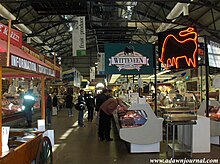
The Eastern Market is a public market in the Capitol Hill neighborhood of Washington, D.C., housed in a 19th-century brick building. Eastern Market was listed on the National Register of Historic Places in 1971. It is located on 7th Street, S.E., a few blocks east of the U.S. Capitol between North Carolina Avenue SE and C Street SE. Badly damaged by an early-morning fire in 2007, the market building reopened in the summer of 2009 following an extensive renovation.

The Old City Hall is a Romanesque-style civic building and court house in Toronto, Ontario, Canada. It was the home of the Toronto City Council from 1899 to 1966 and remains one of the city's most prominent structures.

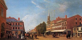
Quincy Market is a historic building near Faneuil Hall in downtown Boston, Massachusetts. It was constructed between 1824 and 1826 and named in honor of mayor Josiah Quincy, who organized its construction without any tax or debt. The market is a designated National Historic Landmark and a designated Boston Landmark in 1996, significant as one of the largest market complexes built in the United States in the first half of the 19th century. According to the National Park Service, some of Boston's early slave auctions took place near what is now Quincy Market.

1 Spadina Crescent, also known as the Daniels Building, is an academic building home to the John H. Daniels Faculty of Architecture, Landscape, and Design at the University of Toronto in Toronto, Ontario, Canada. The building is situated in the centre of a roundabout of Spadina Avenue, north of College Street. Its location provides a picturesque vista looking north up Spadina Avenue; it is an axial view terminus for Spadina Avenue.

The Grange is a historic Georgian manor in downtown Toronto, Ontario. It was the first home of the Art Museum of Toronto. Today, it is part of the Art Gallery of Ontario.

The Queen Victoria Building is a heritage-listed late-nineteenth-century building designed by the architect George McRae located at 429–481 George Street in the Sydney central business district, in the Australian state of New South Wales. The Romanesque Revival building was constructed between 1893 and 1898 and is 30 metres (98 ft) wide by 190 metres (620 ft) long. The domes were built by Ritchie Brothers, a steel and metal company that also built trains, trams and farm equipment. The building fills a city block bounded by George, Market, York, and Druitt Streets. Designed as a marketplace, it was used for a variety of other purposes, underwent remodelling, and suffered decay until its restoration and return to its original use in the late twentieth century. The property is owned by the City of Sydney and was added to the New South Wales State Heritage Register on 5 March 2010.

Kitchener City Hall is the seat of municipal government of Kitchener, Ontario, Canada. It has gone through many iterations through the 20th century, culminating in the current building, which opened in 1993.

The Sydney Town Hall is a late 19th-century heritage-listed town hall building in the city of Sydney, the capital city of New South Wales, Australia, housing the chambers of the Lord Mayor of Sydney, council offices, and venues for meetings and functions. It is located at 483 George Street, in the Sydney central business district opposite the Queen Victoria Building and alongside St Andrew's Cathedral. Sited above the Town Hall station and between the city shopping and entertainment precincts, the steps of the Town Hall are a popular meeting place.

Old Toronto is an administrative district and the retronym of the area within the original city limits of Toronto, Ontario, Canada, from 1834 to 1998. It was first incorporated as a city in 1834, after being known as the town of York, and became part of York County. Toronto periodically grew in size by annexing adjacent land.

The Market House is a Market house and town hall in the center of Fayetteville, Cumberland County, North Carolina. It was built in 1838 on the site of the old state house and Town Hall which burned down in 1831. Fayetteville was the capital of North Carolina from 1789 to 1794.

Jarvis Street is a north-south thoroughfare in downtown Toronto, Ontario, Canada, passing through some of the oldest developed areas in the city. Its alignment extends from Queens Quay East in the south to Bloor Street in the north. The segment south of Front Street is known as "Lower Jarvis Street" while the segment from Bloor Street to Mount Pleasant Road is known as "Ted Rogers Way".
Toowoomba City Hall is a heritage-listed town hall at 541 Ruthven Street, Toowoomba, Toowoomba Region, Queensland, Australia. It was designed by Willoughby Powell and built in 1900 by Alexander Mayne. It is also known as Toowoomba Town Hall. It was added to the Queensland Heritage Register on 21 October 1992.

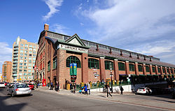
St. Lawrence Market is a major public market in Toronto, Ontario, Canada. It is located along Front Street East and Jarvis Street in the St. Lawrence neighbourhood of downtown Toronto. The public market is made up of two sites adjacent to one another west of Jarvis Street, St. Lawrence Market North, and St. Lawrence Market South. St. Lawrence Market South is situated south of Front Street East, and is bounded by The Esplanade to the south. St. Lawrence Market North is situated north of Front Street East, and is bounded by St. Lawrence Hall to the north.

St. Lawrence Market North is a public market in Toronto, Ontario, Canada. It hosts a variety of markets, including a farmers' market, an antique market and Christmas trees daily from mid-Nov. to Dec. 24. The site has been a farmer's market since 1803. Several buildings have been built for the Market North, the most recent in 1968. The new Market North structure is now under construction. The St. Lawrence Market combines the North building, the St. Lawrence Hall and the St. Lawrence Market South building.
The Great Fire of Toronto of 1849, April 7, 1849, also known as the Cathedral Fire, was the first major fire in the history of Toronto, Ontario, Canada. Much of the Market Block, the business core of the city, was wiped out, including the predecessor of the current St. James Cathedral. The 1831 building of the Toronto City Hall and St. Lawrence Market south of King was damaged and was torn down.
The University of Toronto Mississauga is a satellite campus of the University of Toronto. It is in Mississauga, Ontario, Canada about 33 kilometres west of the main St. George campus. It was formerly called the Erindale College but was later changed to the University of Toronto Mississauga (UTM). The campus has eight main educational buildings: the Maanjiwe nendamowinan Building, Deerfield Hall, the William G. Davis Building, the Kaneff Centre and Blackwood Gallery, the Recreation, Athletic, and Wellness Centre, the Hazel McCallion Academic Learning Centre which holds UTM's library, the Instructional Building, and the new Terrence Donnelly Health Sciences Complex for the Mississauga Academy of Medicine. The campus also houses 3 residence halls: Erindale Hall, Roy Ivor Hall, and Oscar Peterson Hall.

The Esplanade is an east-west street along the central waterfront of Toronto, Ontario, Canada. Originally conceived as a city beautification project to clean up the city's waterfront in the 1850s, the street was taken over by the coming of the railways to Toronto in 1850. The railway eventually moved to an elevated viaduct, leaving only the eastern section of the street today. The area, east of Yonge Street, was dominated by industrial uses until the second half of the 20th century. As the harbour declined as a transfer point, the railway and industrial uses left the area. The Esplanade was redeveloped into a residential area, known as the "St. Lawrence Neighbourhood" in the late 1970s and early 1980s. This neighbourhood consists of generally low-rise and mid-rise housing - condominiums, public housing, cooperatives and some town homes between Jarvis and Parliament Streets south of Front Street. In the blocks between Jarvis and Parliament, the southern part of the street were converted to a long strip of park and recreation space for the residents - David Crombie Park. The stretch between Scott Street and Market Street is a popular restaurant area.