Stations in West Hampstead

Last updated

Stations in West Hampstead
BSicon d.svg
BSicon CONTg.svg
BSicon numN090.svg
BSicon d.svg
BSicon STR.svg
BSicon uvCONTg.svg
BSicon d.svg
BSicon STR.svg
BSicon uvSTR.svg
BSicon CONTg.svg
BSicon dCONTgq.svg
BSicon KRZo.svg
BSicon MSTR.svg
BSicon uvBRUCKE1.svg
BSicon STRq.svg
BSicon STR+r.svg
BSicon STR.svg
BSicon d.svg
BSicon HUBrg-R.svg
BSicon STR.svg
BSicon HUB-Lq.svg
BSicon uvSTR.svg
BSicon lBHF-.svg
BSicon HUB-Lq.svg
BSicon STR.svg
BSicon l-BHF.svg
BSicon HUBlg-L.svg
BSicon STR.svg
Overground roundel (no text).svg London Overground station
ThameslinkSymbol.svg Thameslink station
BSicon d.svg
BSicon HUB-R.svg
BSicon SKRZ-G2u.svg
BSicon uvSKRZ-G2u.svg
BSicon SKRZ-G2u.svg
BSicon HUB-L.svg
BSicon SKRZ-G2u.svg
West Hampstead
BSicon d.svg
BSicon HUBlf-R.svg
BSicon STR.svg
BSicon HUB-Rq.svg
BSicon uvBHF-STR.svg
BSicon HUB-Rq.svg
BSicon STR.svg
BSicon HUBrf-L.svg
BSicon STR.svg
BSicon d.svg
BSicon STR.svg
BSicon uvSTR.svg
BSicon STR2.svg
BSicon STR3u.svg
BSicon d.svg
BSicon STR.svg
BSicon HUB2.svg
BSicon uvBHF.svg
BSicon HUBc3.svg
BSicon STR+1u.svg
BSicon STR+4.svg
Jubilee line roundel (no text).svg Metropolitan line roundel (no text).svg Finchley Road
OSI: Overground roundel (no text).svg
BSicon d.svg
BSicon STR.svg
BSicon HUBc1.svg
BSicon uvSTR.svg
BSicon HUB2+4.svg
BSicon eBHF.svg
BSicon HUBc3.svg
BSicon STR.svg
Finchley Road
(MR) (1868–1927)
BSicon d.svg
BSicon STR.svg
BSicon uvSTR.svg
BSicon HUBc1.svg
BSicon STR.svg
BSicon HUB4.svg
BSicon BHF.svg
Overground roundel (no text).svg Finchley Road & Frognal
OSI: Jubilee line roundel (no text).svg Metropolitan line roundel (no text).svg
BSicon d.svg
BSicon STR.svg
BSicon uvSTR.svg
BSicon STR.svg
BSicon CONTl+g.svg
BSicon d.svg
BSicon STR.svg
BSicon uvSTR.svg
BSicon CONTf.svg
BSicon d.svg
BSicon STR.svg
BSicon uvCONTf.svg
BSicon d.svg
BSicon CONTf.svg

West Hampstead is an area in north-west London, England that is served by a number of different stations, all of which have very similar names. Although physically separate, they are near each other and the stations form a railway interchange. Two of the stations are part of the National Rail network and the third is on the London Underground.

Contents

The three stations – located north to south on West End Lane are:

Stations and lines

West Hampstead Thameslink railway station is the oldest of the three stations, but acquired its name when the Thameslink route was established in 1988. Earlier names included West End, West End and Brondesbury, West Hampstead and until 1988, West Hampstead Midland. It is located on the western side of West End Lane at the Iverson Road junction. Services are operated by Thameslink. As of 2018, annual usage was 3.8 million.

West Hampstead railway station is on the North London Line, with train services provided by London Overground. It was known as West End Lane until 1975. It is on the western side of West End Lane between the tube station and Iverson Road. As of 2018, annual usage was 4.5 million.

West Hampstead tube station is on London Underground Jubilee line. It is on the eastern side of West End Lane near Broadhurst Gardens. It was a Bakerloo line station until 1979. As of 2018, annual usage was 10.5 million.

Additionally, three railway lines pass through West Hampstead but do not have stations in the area; they are:

Current interchange

Lines and stations Westhampsteadstations.svg
Lines and stations

To change stations passengers leave one and walk along West End Lane to the other. The diagram shows the relative locations of the stations which are spaced over about 200 metres (220 yards). Out-of-station interchange within twenty minutes between any two of the stations entails no additional charge. [1] As an example: a journey from Richmond to St Albans may be made on one ticket with a walk between the North London Line and the Thameslink stations. Step free access is available at the Thameslink and Overground stations.

West Hampstead Interchange proposal

In 2003, Chiltern Railways unveiled a proposal to redevelop the area along West End Lane to create an integrated station complex which would allow passenger interchange among five different Tube and railway lines. [2] The scheme envisaged building new platforms on the Chiltern Main Line and the Metropolitan lines, and relocating the Thameslink and London Overground stations to the east side of West End Lane. The combined station would have a central passenger concourse and ticket hall, and pedestrian walkways would connect the stations. [3] The scheme also proposed the construction of a new housing and office development and widening West End Lane, turning it into "a tree-lined boulevard" with additional space for buses and taxis. [4] [5]

The plans were put on hold in 2007 due to uncertainty over the North London Line rail franchise. [6] The proposal is now no longer possible, due to development in the area. Furthermore, both the Thameslink station and the Overground station have been rebuilt and upgraded in recent years, with step free access added to both. [7]

Current services

West Hampstead Underground station
Preceding station Underground no-text.svg London Underground Following station
Kilburn
towards Stanmore
Jubilee line Finchley Road
towards Stratford
West Hampstead Thameslink railway station
Preceding station National Rail logo.svg National Rail Following station
Thameslink
Thameslink
Thameslink
Sutton Loop
Thameslink
Bedford-Sevenoaks
West Hampstead railway station
Preceding station Overground notextroundel.svg National Rail logo.svg London Overground Following station
Brondesbury North London line Finchley Road & Frognal
towards Stratford

Related Research Articles

<span class="mw-page-title-main">Finsbury Park station</span> London Underground and railway station

Finsbury Park is an intermodal interchange station in north London. It serves a number of National Rail, London Underground and bus services. The station is the third busiest Underground station outside Zone 1, with over 33 million passengers using the station in 2019.

<span class="mw-page-title-main">Highbury & Islington station</span> London Underground and railway station

Highbury & Islington is a London Underground and National Rail interchange station in the London Borough of Islington, north London. It is served by the London Underground's Victoria line and the Great Northern's Northern City Line, as well as the London Overground's East and North London Lines.

<span class="mw-page-title-main">Camden Town tube station</span> London Underground station

Camden Town is a London Underground station on the Northern line. It is a major junction for the line, as it is where the Edgware and High Barnet branches merge from the north, and is also where they split to the south into the Bank and Charing Cross branches for the journey through Central London. It is particularly busy with visitors to the Camden markets at weekends, and, until 2019, was exit-only on Sundays to prevent overcrowding.

<span class="mw-page-title-main">North London line</span> Railway line in London

The North London line (NLL) is a railway line which passes through the inner suburbs of west, north-west, north, and east London, England between Richmond in the south-west and Stratford in the east, avoiding central London. Its route is a rough semicircle.

<span class="mw-page-title-main">West Hampstead tube station</span> London Underground station

West Hampstead is a London Underground station in West Hampstead. It is located on West End Lane between Broadhurst Gardens and Blackburn Road and is situated in Travelcard Zone 2. It is on the Jubilee line between Kilburn and Finchley Road stations. It is 100 m (110 yd) from West Hampstead station on the London Overground North London line and 200 m (220 yd) from West Hampstead Thameslink station. Metropolitan line trains also pass through the station, but do not usually stop.

<span class="mw-page-title-main">Kentish Town station</span> London Underground and railway station

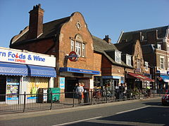
Kentish Town is a London Underground and National Rail station in Kentish Town in the London Borough of Camden. It is at the junction of Kentish Town Road (A400) and Leighton Road. It is in Travelcard Zone 2. The station is served by the High Barnet branch of the London Underground Northern line, and by Thameslink trains on the National Rail Midland Main Line. It is the only station on the High Barnet branch with a direct interchange with a National Rail line; furthermore an Out of Station Interchange (OSI) with Kentish Town West on the North London line is not charged as two separate journeys in electronic journey charging.

<span class="mw-page-title-main">Gospel Oak railway station</span> London Overground station

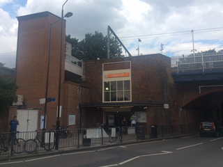
Gospel Oak railway station is in the London Borough of Camden in north-west London. It is on the North London line (NLL) and is also the western passenger terminus of the Gospel Oak to Barking Line – known informally as GOBLIN. Passengers using Oyster cards are required to tap on interchange Oyster card readers when changing between the two lines. The station is in Travelcard Zone 2, and is managed by London Overground which runs all passenger trains at the station.

<span class="mw-page-title-main">Barking station</span> Interchange railway station in London

Barking is an interchange station serving the town of Barking, east London. It is served by London Underground, London Overground and National Rail main line services. It is located on Station Parade, in the town centre.

<span class="mw-page-title-main">Camden Road railway station</span> London Overground station

Camden Road railway station in the London Borough of Camden, north London, is operated by London Overground. It is on the North London line and in Travelcard Zone 2.

<span class="mw-page-title-main">South Tottenham railway station</span> London Overground station

South Tottenham is a railway station on the east–west Gospel Oak to Barking Line of the London Overground. It is located on the eastern side of the north–south A10 High Road in Tottenham, North London, 5 miles 69 chains (9.4 km) from St Pancras and situated between Harringay Green Lanes and Blackhorse Road. It is in Zone 3, in the London Borough of Haringey. South Tottenham to Seven Sisters station is considered an official out-of-station interchange by the National Rail timetable, and involves a short walk. This link will become fixed under the planned route for Crossrail 2, which sees a double-ended underground station built linking together South Tottenham and Seven Sisters stations.

West Hampstead is an area in the London Borough of Camden in north-west London. Mainly defined by the railway stations of the same name, it is situated between Childs Hill to the north, Frognal and Hampstead to the north-east, Swiss Cottage to the east, South Hampstead to the south-east, Kilburn to the west and south-west, and Cricklewood to the north-west. The area is mainly residential with several small shops, restaurants, cafes, bakeries concentrated on the northern section of West End Lane and around West End Green. It is served by three stations: West Hampstead on the Jubilee line, West Hampstead Overground station and West Hampstead Thameslink station. It is part of the Kilburn postal district (NW6).

<span class="mw-page-title-main">Cricklewood railway station</span> National Rail station in London, England

Cricklewood railway station is on the Midland Main Line in England, serving the town of Cricklewood in the London Borough of Barnet, north London. It is 5 miles 9 chains (8.2 km) down the line from St Pancras and is situated between West Hampstead Thameslink to the south and Hendon to the north. Its three-letter station code is CRI.

<span class="mw-page-title-main">South Hampstead railway station</span> London Overground railway station in the London Borough of Camden

South Hampstead railway station is on Loudoun Road in the London Borough of Camden. It is served by London Overground services on the Watford DC line. It is about 550 yards (500 m) south west of Swiss Cottage Underground station.

<span class="mw-page-title-main">Watford DC line</span> London Overground line

The Watford DC line is a suburban line from London Euston to Watford Junction in Watford, Hertfordshire. Its services are operated by London Overground.

<span class="mw-page-title-main">London Overground</span> London suburban rail network

London Overground is a suburban rail network serving London and its environs. Established in 2007 to take over Silverlink Metro routes, it now serves a large part of Greater London as well as the home county of Hertfordshire, with 113 stations on nine different routes.

<span class="mw-page-title-main">Old Oak Common railway station</span> Planned railway station in London

Old Oak Common (OOC) is a railway station under construction on the site of the Old Oak Common traction maintenance depot to the west of London in Old Oak Common, approximately 500 m (1,600 ft) south of Willesden Junction station. When built, it is expected to be one of the largest rail hubs in London, at about 800 m (2,600 ft) in length and 20 m (66 ft) below surface level.

<span class="mw-page-title-main">Dudding Hill line</span>

The Dudding Hill Line is a railway line in west and north-west London running from Acton to Cricklewood. It is roughly 4 miles (6.4 km) long, with a 30 miles per hour (48 km/h) speed limit, and semaphore signalling. The line has no scheduled passenger service, no stations, and is not electrified. It is lightly used by freight trains and, very occasionally, passenger charter trains.

<span class="mw-page-title-main">East Brixton railway station</span> Abandoned train stop in London

East Brixton railway station was a railway station in Brixton, south London. It was opened as Loughborough Park by the London, Brighton & South Coast Railway in 1866. Regular passenger service was the South London line from London Victoria to London Bridge terminal stations in central London. Initially provided with a steam passenger service, competition from electric trams caused a conversion to overhead line electric operation in 1909. The station became part of the Southern Railway in 1923 and overhead line electrification was swapped for third rail in 1928. The station lost patronage after the opening of Brixton Underground station in 1971. There was a fire at the station in 1975 and it was closed by British Rail in January 1976. The station was located next to the rail bridge over Barrington Road, near Coldharbour Lane. Since 2012 London Overground trains pass through the site of the former station without stopping and there has been some campaigning to reopen it.

<span class="mw-page-title-main">West Hampstead railway station</span> London Overground station

West Hampstead railway station is a London Overground station on the North London Line between Brondesbury and Finchley Road & Frognal in the London Borough of Camden and is in Travelcard Zone 2.

<span class="mw-page-title-main">London Borough of Camden</span> Borough in United Kingdom

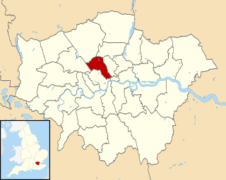
The London Borough of Camden is a London borough in Inner London. Camden Town Hall, on Euston Road, lies 1.4 mi (2.3 km) north of Charing Cross. The borough was established on 1 April 1965 from the area of the former boroughs of Hampstead, Holborn, and St Pancras—which together, prior to that date, had comprised part of the historic County of London.

References

  1. "Out of Station Interchange (OSI)". Oyster and National Rail (independent guide). 24 March 2010. Archived from the original on 9 July 2010.
  2. Wright, Jane (24 July 2003). "Super station waiting on the drawing board". Camden New Journal. New Journal Enterprises. Archived from the original on 31 October 2004. Retrieved 5 September 2018.
  3. "Planning Framework for West Hampstead Interchange Area Appendix 2". London Borough of Camden. 19 April 2005. p. 25. Archived from the original on 11 June 2011.
  4. "West Hampstead Interchange". Always Touch Out. 11 January 2006. Archived from the original on 12 July 2004.
  5. "West Hampstead Interchange Draft Planning Framework". London Borough of Camden. 19 April 2005. Archived from the original on 24 October 2007.
  6. "Station interchange plans put on hold". Camden New Journal. 15 March 2007. Archived from the original on 16 July 2011.
  7. "Thameslink station redevelopment gets go-ahead". New Civil Engineer. Retrieved 18 September 2016.

Coordinates: 51°32′51″N0°11′29″W / 51.54750°N 0.19139°W / 51.54750; -0.19139