Upper Takutu-Upper Essequibo

Last updated
Upper Takutu-Upper Essequibo
Region 9
Administrative Region
Lethem.jpg
Flag green white red 5x3.svg
Upper Takutu-Upper Essequibo in Guyana.svg
Map of Guyana showing Upper Takutu-Upper Essequibo region
CountryFlag of Guyana.svg  Guyana
Regional Capital Lethem
Area
  Total57,750 km2 (22,300 sq mi)
Population
 (2012 census)
  Total24,212
  Density0.42/km2 (1.1/sq mi)
[1]

Upper Takutu-Upper Esequibo (Region 9) is a region of Guyana. It borders the region of Potaro-Siparuni to the north, the region of East Berbice-Corentyne to the east and Brazil to the south and west. It contains the town of Lethem, and the villages of Aishalton, Nappi and Surama. It is also the largest region of Guyana.

Contents

The Rupununi savannah known for its large biodiversity is located between the Rupununi River and the Brazilian border. [2] Within the Upper Takutu-Upper Esequibo is part of the Guianan savanna ecoregion.

Population

The Government of Guyana has administered three official censuses since the 1980 administrative reforms, in 1980, 1991 and 2002. [3] In 2012, the population of Upper Takutu-Upper Essequibo was recorded at 24,212 people. [4] Official census records for the population of the Upper Takutu-Upper Essequibo region are as follows:

Surama Surama Eco Lodge.jpg
Surama

Communities

List of communities (including name variants): [5]

Territorial claim

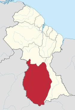
Venezuela has renewed its claim to the Essequibo region which is situated west of the Essequibo river. [6] The status of the border controversy is subject to the Geneva Agreement, which was signed by the United Kingdom, Venezuela and British Guiana on 17 February 1966. As of December 2020, the matter is being addressed by the International Court of Justice. [7]

See also

Related Research Articles

<span class="mw-page-title-main">Barima-Waini</span> Region of Guyana

Barima-Waini is a region of Guyana and is located in the northwest of the country. Barima-Waini has three sub-regions: Mabaruma, Matakai, and Moruca.

<span class="mw-page-title-main">Rupununi</span> River in Guyana

The Rupununi is a region in the south-west of Guyana, bordering the Brazilian Amazon. The Rupununi river, also known by the local indigenous peoples as Raponani, flows through the Rupununi region. The name Rupununi originates from the word rapon in the Makushi language, in which it means the black-bellied whistling duck found along the river.

<span class="mw-page-title-main">Cuyuni-Mazaruni</span> Region of Guyana

Cuyuni-Mazaruni is a region of Guyana. Its capital is Bartica, with villages including Issano, Kartabo, Kamarang, and Imbaimadai.

<span class="mw-page-title-main">East Berbice-Corentyne</span> Region of Guyana

East Berbice-Corentyne is one of ten regions in Guyana covering the whole of the east of the country. It borders the Atlantic Ocean to the north, the Nickerie District and Sipaliwini District of Suriname to the east, Brazil to the south and the regions of Mahaica-Berbice, Upper Demerara-Berbice, Potaro-Siparuni and Upper Takutu-Upper Essequibo to the west.

<span class="mw-page-title-main">Essequibo Islands-West Demerara</span> Region of Guyana

Essequibo Islands-West Demerara is a region of Guyana. It is situated around the Essequibo River, the largest river in Guyana that lies between the Orinoco and Amazon rivers of South America.

<span class="mw-page-title-main">Potaro-Siparuni</span> Region of Guyana

Potaro-Siparuni is a region of Guyana. It borders the region of Cuyuni-Mazaruni to the north, the regions of Upper Demerara-Berbice and East Berbice-Corentyne to the east, the region of Upper Takutu-Upper Essequibo to the south and Brazil to the west.

<span class="mw-page-title-main">Rupununi savannah</span> Savanna plain in Upper Takutu-Upper Essequibo, Guyana

The Rupununi savannah is a savanna plain in Guyana, in the Upper Takutu-Upper Essequibo region. It is part of the Guianan savanna ecoregion of the tropical and subtropical grasslands, savannas, and shrublands biome.

Apoteri is a village in the Upper Takutu-Upper Essequibo Region of Guyana, near the confluence of the Rupununi River with the Essequibo, at an altitude of 53 metres. Apoteri started to develop as the centre of the balatá industry. The population is mainly Amerindian of the Macushi and Wapishana people.

<span class="mw-page-title-main">Takutu River</span> River in Brazil, Guyana

The Takutu River is a river in the Upper Takutu-Upper Essequibo Region of Guyana and Roraima in Brazil. It forms part of the boundary between the two countries. The confluence of the Takutu and Uraricoera Rivers forms the Branco River. The Takutu River's sources almost link with those of the Essequibo River; in the rainy season, flooding links the Takutu to the Rupununi River, a tributary of the Essequibo.

Dadanawa Ranch is located on the Rupununi River in the Rupununi savannah in the Upper Takutu-Upper Essequibo Region of Guyana. It is the largest and one of the most isolated cattle ranches in Guyana.

Aishalton is an Amerindian village that is situated in the Rupununi savannah of southern Guyana, in the Upper Takutu-Upper Essequibo Region of the country.

The Kwitaro River is a tributary of the Rupununi River in Guyana.

Wowetta is an indigenous village in the Upper Takutu-Upper Essequibo Region in Guyana. The village is mainly inhabited by Macushi people.

Surama is an Amerindian village in the North Rupununi area and the Upper Takutu-Upper Essequibo Region of Guyana, with a population of 274 people as of 2012.

<span class="mw-page-title-main">Sydney Allicock</span> Guyanese politician

Sydney Charles Allicock is a Guyanese politician. He was minister of Indigenous People's Affairs in Guyana from 2015-2020, and was vice-president of Guyana from 2015-2020.

Hiawa is an indigenous village of Macushi Amerindians in the Upper Takutu-Upper Essequibo Region of Guyana. It is located in the Rupununi savannah. Hiawa is considered a satellite of Nappi.

St. Ignatius is an Amerindian village in the Upper Takutu-Upper Essequibo region of Guyana, near the regional capital Lethem and the border of Brazil. It was originally a mission founded by Jesuit priests to serve the Amerindians in the Rupununi savannah.

Toka is an indigenous village of Macushi Amerindians in the Upper Takutu-Upper Essequibo Region of Guyana. It is located in the North Rupununi Wetlands.

Nappi is an indigenous village of Macushi Amerindians in the Upper Takutu-Upper Essequibo Region of Guyana. It is located in the Rupununi savannah along the Nappi and Maipaima creeks on the edge of the Kanuku Mountains.

References

  1. Macmillan Publishers (2009). "Administrative Regions - 8, 9 and 10". Macmillan Junior Atlas: Guyana. Oxford: Macmillan Caribbean. p. 37. ISBN   9780333934173.
  2. "Guyana's Rupununi Land of Nature, Authentic Culture, and Adventure". Rupununi. Retrieved 19 August 2020.
  3. Beaie, Sonkarley Tiatun (19 September 2007). "Chapter 3: National Redistribution and Internal Migration" (PDF). 2002 Population and Housing Census - Guyana National Report. Bureau of Statistics. p. 51. Archived from the original (PDF) on 17 February 2012. Retrieved 29 August 2012.
  4. Beaie, Sonkarley Tiatun (19 September 2007). "National Population Trends: Size, Growth and Distribution" (PDF Download). 2002 Population and Housing Census - Guyana National Report. Bureau of Statistics. p. 25. Retrieved 29 August 2012.
  5. "2012 Population by Village". Statistics Guyana. Retrieved 8 December 2021.
  6. "Official Announcements". Archived from the original on 8 September 2016. Retrieved 28 July 2016.
  7. Summary of the Judgement of 18 December 2020

2°54′04″N58°56′07″W / 2.900996°N 58.93517°W / 2.900996; -58.93517