West Ham station

Last updated

West Ham District line roundel (no text).svg H&c line roundel (no text).svg Jubilee line roundel (no text).svg DLR no-text roundel.svg National Rail logo.svg
West Ham station MMB 12.jpg
Greater London UK location map 2.svg
Red pog.svg
West Ham
Location of West Ham in Greater London
Location West Ham
Local authority London Borough of Newham
Managed by London Underground
Station codeWEH
DfT category C1
Number of platforms8
AccessibleYes [1] [2]
Fare zone 2 and 3
DLR annual boardings and alightings
2018Increase2.svg 3.500 million [3]
2019Increase2.svg 3.523 million [4]
2020Decrease2.svg 2.044 million [5]
2021Decrease2.svg 2.006 million [6]
2022included in Underground usage [7]
National Rail annual entry and exit
2018–19Increase2.svg 10.717 million [8]
2019–20Decrease2.svg 10.181 million [8]
2020–21Decrease2.svg 4.012 million [8]
– interchange 2,994 [8]
2021–22Increase2.svg 7.451 million [8]
– interchange Increase2.svg 5,371 [8]
2022–23Increase2.svg 9.052 million [8]
– interchange Decrease2.svg 5,268 [8]
Railway companies
Original company London, Tilbury and Southend Railway
Pre-grouping Midland Railway
Post-grouping London, Midland and Scottish Railway
Key dates
1 February 1901Opened (LT&SR/NLR)
1902District line started
1913London–Southend withdrawn
1 January 1916NLR withdrawn
1936Hammersmith & City started
14 May 1979North London service started
14 May 1999c2c and Jubilee line started
9 December 2006North London service withdrawn
31 August 2011DLR started [9]
Other information
External links
Coordinates 51°31′41″N0°00′14″E / 51.528°N 0.004°E / 51.528; 0.004
Underground sign at Westminster.jpg London transportportal

West Ham is a London Underground, Docklands Light Railway (DLR) and National Rail intermodal interchange station in West Ham, London, United Kingdom. The station is served by London Underground's District, Hammersmith & City and Jubilee lines, the Stratford International branch of the DLR, and c2c National Rail services.

Contents

The station was opened in 1901 by the London, Tilbury and Southend Railway on the route from Fenchurch Street to Barking. In the late 1990s, the station was rebuilt and significantly expanded as part of the Jubilee Line Extension, fully opening in 1999. The station is in London fare zone 2 and zone 3.

History

East to west alignment

The London, Tilbury and Southend Railway direct line from Bow to Barking was constructed east to west through the middle of the Parish of West Ham in 1858. Before this, trains took a longer route via Stratford and Forest Gate to the north. The new line opened with stations initially at Bromley, Plaistow and East Ham. In November 1897 Arnold Hills, the owner of the Thames Ironworks and Shipbuilding Company, whose football team Thames Ironworks F.C. (which reformed in 1900 as West Ham United) played at the Memorial Grounds, secured an agreement with the London, Tilbury and Southend Railway to build a station at the intersection of Manor Road and Memorial Avenue. The company board approved this in February 1898 and Mowlem's was given the contract to build a four platform station, which allowed for the proposed quadrupling of the line with the completion of the Whitechapel and Bow Railway. The station was completed in May 1900, but did not open until 1 February 1901. The station was initially known as West Ham.

The North London Railway had run a daily service to Plaistow via the Bow-Bromley curve since 18 May 1869 and when West Ham opened it used the northern platforms. In 1905 they switched to the southern platforms, with the opening of a new bay platform at Plaistow on the southern side. [10] The Whitechapel and Bow Railway allowed through services of the Metropolitan District Railway to operate through West Ham to Upminster from 1902. The Metropolitan District converted to electric trains in 1905 and services were cut back to East Ham. The London, Tilbury and Southend Railway trains from Fenchurch Street used the southern platforms when the Metropolitan District services began but stopping was reduced to a few a week in 1908 and to nil in 1913. Ownership of the station passed to the Midland Railway in 1912 and the London, Midland and Scottish Railway in 1923. The station was renamed West Ham (Manor Road) on 11 February 1924. When the North London Railway service to Plaistow ceased on 1 January 1916 the southern platforms were unused in normal service.

The Metropolitan District Railway was incorporated into London Transport in 1933, and became known as the District line. Hammersmith & City line services started, as part of the Metropolitan line, in 1936. The southern platforms were removed after war damage in 1940 which had completely closed the station from 7 September 1940 until 11 August 1941. [11] After nationalisation of the railways in 1948 management of the station passed to British Railways. In 1969 ownership was transferred to the London Underground and the station was renamed back to West Ham on 1 January.

On 15 March 1976, nine people were injured here by an explosion on a train by a member of the Provisional IRA. Julius Stephen, the driver of the train, was shot dead at the scene when he attempted to pursue the fleeing bomber. [12]

As part of the Jubilee Line Extension, the station was completely rebuilt, with reconstructed District and Hammersmith and City line platforms. In addition, platforms were re-established on the main line from Fenchurch Street, now operated by c2c. As part of the work, the existing entrance was closed, and the refurbished ticket hall became a connecting concourse to the new ticket hall and the rest of the station. Additionally, the station was made fully accessible. [13]

The island platform for c2c services, along with the access staircases, are narrow and get easily congested. To ensure safety for passengers, staff must be present on the platforms at peak times. c2c have proposed an escalator to replace the stairs. The construction of an additional platform for westbound trains would eliminate the problem. [14] [15]

London 2012 Summer and Paralympic Games

The footbridge that served the Olympic exit to The Greenway in 2012. Olympic footbridge at West Ham station.JPG
The footbridge that served the Olympic exit to The Greenway in 2012.

The station was temporarily modified to allow it to cope with an increase in passenger numbers during the London 2012 Olympic and Paralympic Games. A footbridge was constructed to connect the station to the Greenway foot and cycle path, which connects directly to the Olympic Park in Stratford. [16]

Work began in January 2011, with the construction of temporary stairs and a walkway from the eastern end of the District line platforms, over the eastbound track and running back parallel to the platform ending at Manor Road. The footbridge was demolished in mid-October 2012, following the end of the 2012 Summer Paralympics. The foundations of the temporary footbridge have been left for possible use in future expansion of the station. [17] A double-ended centre siding east of West Ham was constructed to compensate for lost reversing capacity caused by the rebuilding of Whitechapel station as part of Crossrail work. [18] This was commissioned on 17 January 2011. [19]

North to south alignment

The Eastern Counties and Thames Junction Railway was constructed north to south through West Ham, linking Stratford with Canning Town in 1846. Platforms were constructed on the line at West Ham and opened on 14 May 1979 when the Crosstown Linkline service began between Camden Road and North Woolwich. [20] The Crosstown Linkline was replaced with the electric North London Line service between Richmond and North Woolwich on 13 May 1985. In the 1990s, the station was comprehensively rebuilt as part of the Jubilee Line Extension, designed by van Heyningen and Haward Architects. A new bridge crosses four rail lines and a main road, to connect the Jubilee line and North London line platforms with the new ticket hall and the rest of the station. [13] Jubilee line services began on 14 May 1999. [21] North London Line services at the station ceased on 9 December 2006, when the line from Stratford to North Woolwich was closed, to allow for the line to be converted for the Docklands Light Railway. The platforms reopened on 31 August 2011 as part of the extension to Stratford International. [22]

New entrance

As part of the TwelveTrees development on the former Parcelforce distribution depot, a new station entrance is being built to connect to the upper Jubilee line concourse. [23] [24] As well as this, two new pedestrian bridges over the railway will be built. [23] [24]

Design and architecture

The station was rebuilt as part of the Jubilee Line Extension in the 1990s. [25] [26] The design by van Heyningen and Haward Architects was considered to evoke work by Charles Holden in the 1930s, with use of brick and glass blocks, as well as a clock tower. [25] [27] The station was designed in 27 weeks, and was the cheapest of the new stations to be built. [26] Critics called the station "effortlessly elegant" [26] and an "impressive architectural essay in brick, concrete and glass". [27] It was later awarded a Royal Fine Art Commission Trust Award. [26]

The station consists of four sets of island platforms, two on an elevated east–west alignment and another perpendicular pair at street level, giving a total of eight platform faces. The existing entrance was closed, with the old ticket hall refurbished to become a connecting concourse to the District and Hammersmith & City line platforms and the (new) c2c platforms. A new ticket hall - facing onto Manor Road - connects this concourse to the Jubilee line and North London line platforms via a high level bridge that spans four rail lines and a main road. The station building and connecting passageways are finished in a mixture of red brick, concrete and glass, inspired by Charles Holden. [13] [28] The station was built at a fraction of the cost of other Jubilee Line Extension stations, just £10.5m compared to over £100m at stations like Canary Wharf. [29]

At the upper level, the northern island platform (Platform 1 and 2) are used by District line and Hammersmith & City line trains, and the southern island platform (Platforms 7 and 8) are used by c2c trains. At the lower level, the western island platform (Platforms 5 and 6) are used by Jubilee line trains, with the eastern island platform (Platforms 3 and 4) - formerly the North London line platforms - are now used by Docklands Light Railway trains.

Jubilee line trains can terminate here to enter into the nearby Stratford Market Depot. This is regularly used during peak times/at the end of the working day. Secondly, there is a crossover to the south of the DLR platforms so that trains can reverse early and head back south. Additionally there is a siding that opened in 2011 east of the sub-surface line platforms so that trains from both directions can terminate. [30]

Incidents

On 15 March 1976, seven people were injured by a Provisional IRA bomb on a Metropolitan line train. The terrorist then shot and killed the train's driver Julius Stephen. [31] [12]

Location

The station is located at the corner of Durban Road and Manor Road, in the London Borough of Newham. The station is named after the former parish and borough of West Ham within which it was located to the west of the centre. The neighbourhood of West Ham is located some distance to the north-east. Since West Ham United Football Club moved to the Boleyn Ground in 1904, the station is no longer located near their home ground. East London Rugby Football Club is situated nearby on Holland Road, which is also home to Kings Cross Steelers RFC and Phantoms RFC. [32]

Services

West Ham station signs with a DLR sign in the foreground and a Jubilee line sign in the background. West Ham Station Signage.jpg
West Ham station signs with a DLR sign in the foreground and a Jubilee line sign in the background.

Services at West Ham are operated by c2c, Docklands Light Railway and London Underground on the District, Hammersmith & City and Jubilee lines.

The typical off-peak service in trains per hour (tph) is:

Operator/lineFrequency to destination
c2c [33] Westbound
6 tph to London Fenchurch Street
Eastbound
2 tph to Shoeburyness via Basildon
2 tph to Grays via Rainham
2 tph to Southend Central via Ockendon
London Underground
District line [34]
Westbound
3 tph to Barking
12 tph to Upminster
Eastbound
3 tph to Wimbledon
6 tph to Richmond
6 tph to Ealing Broadway
London Underground
Hammersmith & City line [35]
Westbound
6 tph to Hammersmith
Eastbound
6 tph to Barking
London Underground
Jubilee line [36]
Northbound
24 tph to Stratford
Southbound
4 tph to West Hampstead
4 tph to Willesden Green
4 tph to Wembley Park
12 tph to Stanmore
Docklands Light Railway [37] Northbound
6 tph to Stratford International
Southbound
6 tph to Woolwich Arsenal

The station also served by a night service on Friday and Saturday nights as part of the Night Tube. The station is served by Jubilee line trains every 10 minutes in each direction between Stratford and Stanmore.

Preceding station National Rail logo.svg National Rail Following station
c2c
Preceding station  Underground no-text.svg London Underground  Following station
Bromley-by-Bow
towards Hammersmith
  Hammersmith & City line   Plaistow
towards Barking
Bromley-by-Bow
  District line   Plaistow
towards Upminster
Canning Town
towards Stanmore
  Jubilee line   Stratford
Terminus
Preceding station  DLR no-text roundel.svg DLR  Following station
Abbey Road
  Docklands Light Railway   Star Lane
  Historical railways  
Bromley-by-Bow   British Rail Eastern Region
  Plaistow
Disused railways
Stratford   Silverlink
  Canning Town
 Former services 
Preceding station  Underground no-text.svg London Underground  Following station
Bromley-by-Bow
towards Hammersmith
  Metropolitan line
  Plaistow
towards Barking

Connections

London Bus route 276 serves the station. [38]

Related Research Articles

c2c British train operating company

c2c is a British train operating company owned by Trenitalia that operates the Essex Thameside railway contract. It manages 25 stations and its trains call at 28. c2c provides commuter services from its London Fenchurch Street terminus to parts of East London and south Essex along the London, Tilbury and Southend line. At weekends it also operates from London Liverpool Street.

<span class="mw-page-title-main">Woolwich Arsenal station</span> Docklands Light Railway and National Rail station

Woolwich Arsenal station is an interchange station in the heart of Woolwich in the Royal Borough of Greenwich for Docklands Light Railway (DLR) and National Rail services.

<span class="mw-page-title-main">Limehouse station</span> Docklands Light Railway and National Rail station

Limehouse is a National Rail and connected Docklands Light Railway (DLR) station in Limehouse, London, England. It is served by regional services operated by c2c to and from Fenchurch Street, and by light metro services provided by the DLR to and from Tower Gateway or Bank. On the main line, Limehouse is located 1 mile 58 chains (2.8 km) from Fenchurch Street and the following station is West Ham; on the DLR it is between Shadwell and Westferry in Travelcard Zone 2.

<span class="mw-page-title-main">Canning Town station</span> London Underground and Docklands Light Railway station

Canning Town is an interchange station located in Canning Town, London for London Underground, Docklands Light Railway (DLR) and London Buses services.

<span class="mw-page-title-main">Stratford station</span> London Underground, Docklands Light Railway and National rail station

Stratford is a major multi-level interchange station serving the district of Stratford and the mixed-use development known as Stratford City, in the London Borough of Newham, East London for London Underground, London Overground, Docklands Light Railway (DLR) and Elizabeth line services. National Rail services also operate on the West Anglia Main Line and the Great Eastern Main Line, 4 miles 3 chains (6.5 km) from Liverpool Street.

<span class="mw-page-title-main">Whitechapel station</span> National rail, London Underground and Overground station

Whitechapel is an interchange station in Whitechapel, East London for London Underground, London Overground and Elizabeth line services. The station is located behind a street market of the same name and opposite Tower Hamlets Town Hall. It lies between Aldgate East and Stepney Green stations on the District and Hammersmith & City lines, between Shoreditch High Street and Shadwell stations on the East London Line. To the West of Whitechapel on the Elizabeth Line is Liverpool Street, to the East the line splits with one branch going to Stratford and one to Canary Wharf. It is in Travelcard Zone 2.

<span class="mw-page-title-main">Custom House station</span> Railway and DLR station in London

Custom House is an interchange station by the Royal Docks, in Custom House in the London Borough of Newham, London for Docklands Light Railway (DLR) – on which it is branded Custom House for ExCeL – and Elizabeth line services. It is situated in Travelcard Zone 3.

<span class="mw-page-title-main">Bromley-by-Bow tube station</span> London Underground station

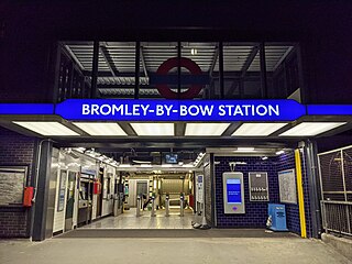
Bromley-by-Bow is a London Underground station located on the Blackwall Tunnel Northern Approach Road in the Bromley-by-Bow area of London, United Kingdom. The station is below the Blackwall Tunnel Northern Approach Road and lies between Bow Road and West Ham stations on the District and Hammersmith & City lines, and is in both Travelcard Zones 2 and 3.

<span class="mw-page-title-main">Barking station</span> Interchange railway station in London

Barking is an interchange station serving the town of Barking, east London. It is served by London Underground, London Overground and National Rail main line services. It is located on Station Parade, in the town centre.

<span class="mw-page-title-main">East Ham tube station</span> London Underground station

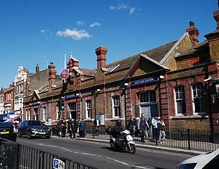
East Ham is a London Underground station on High Street North in the East Ham neighbourhood of the London Borough of Newham in east London, England. The station is on the District line and Hammersmith & City line. The station was opened on 31 March 1858 by the London, Tilbury and Southend Railway on a new more direct route from Fenchurch Street to Barking. The large Edwardian station building was constructed to accommodate the electric District Railway services on an additional set of tracks opened in 1905. It has high and growing usage for a suburban station with 13.1 million entries and exits in 2010. It is in London fares zones 3 and 4.

<span class="mw-page-title-main">Upminster station</span> London Underground and railway station

Upminster is an interchange station serving the town of Upminster in the London Borough of Havering, Greater London. It is on the London, Tilbury and Southend line (LTSR), 15 miles 20 chains (24.5 km) down the line from London Fenchurch Street; it is the eastern terminus of the District line on the London Underground; and it is the eastern terminus of the Romford to Upminster Line on the London Overground network. Upminster is the easternmost station on the London Underground network as well as the easternmost National Rail station in London.

<span class="mw-page-title-main">London, Tilbury and Southend line</span> Commuter railway line in Essex, England

The London, Tilbury and Southend line, also known as Essex Thameside, is a commuter railway line on the British railway system. It connects Fenchurch Street station, in central London, with destinations in east London and Essex, including Barking, Upminster, Basildon, Grays, Tilbury, Southend and Shoeburyness.

<span class="mw-page-title-main">Hornchurch tube station</span> London Underground station

Hornchurch is a London Underground station serving the town of Hornchurch in the London Borough of Havering, east London. It is on the District line between Elm Park to the west and Upminster Bridge to the east. It is 2.5 kilometres (1.6 mi) along the line from the eastern terminus at Upminster and 31.7 kilometres (19.7 mi) to Earl's Court in central London where the line divides into numerous branches.

<span class="mw-page-title-main">Dagenham Dock railway station</span> National Rail station in London, England

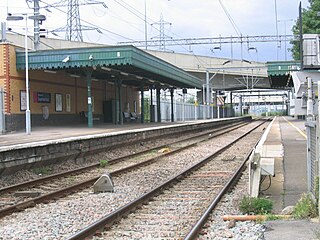
Dagenham Dock is a National Rail station in the Dagenham Dock neighbourhood of Dagenham in the London Borough of Barking and Dagenham, east London. The station is on the Tilbury loop of the London, Tilbury and Southend line, located 10 miles 45 chains (17.0 km) down the line from London Fenchurch Street between Barking to the west and Rainham to the east. The station was opened in 1908 by the London, Tilbury and Southend Railway. The station serves a primarily industrial area adjacent to the River Thames, including the Ford Dagenham site, that is now going through redevelopment as a commercial and residential district. Its three-letter station code is DDK and it is in London fare zone 5. The station and all trains serving it are currently operated by c2c. It is an interchange with the East London Transit bus service.

<span class="mw-page-title-main">Plaistow tube station</span> London Underground station

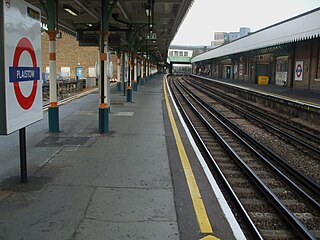
Plaistow is a London Underground station on Plaistow Road in the London Borough of Newham in Greater London. It is between West Ham and Upton Park stations on the District and Hammersmith & City lines, and in Travelcard Zone 3.

<span class="mw-page-title-main">Bow railway station</span> Disused railway station in England

Bow was a railway station in Bow, east London, that was opened in 1850 by the East & West India Docks and Birmingham Junction Railway, which was later renamed the North London Railway (NLR). The station was situated between Old Ford and South Bromley, and was located on the north side of Bow Road, close to the second Bow Road station which was open from 1892 to 1949. A covered footway connected the two stations between 1892 and 1917.

<span class="mw-page-title-main">Stratford High Street DLR station</span> Docklands Light Railway station

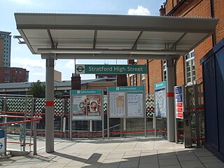
Stratford High Street is a Docklands Light Railway station in Stratford in London, England. It is located on the Stratford International branch of the Docklands Light Railway, which opened on 31 August 2011. The site was the location of an earlier railway station from 1847 to 1957, known initially as Stratford Bridge and later as Stratford Market - after the nearby wholesale fruit and vegetable market.

<span class="mw-page-title-main">Abbey Road DLR station</span> Docklands Light Railway station

Abbey Road DLR station is a Docklands Light Railway station in West Ham in the London Borough of Newham, in east London, England. It is located on the Stratford International extension of the Docklands Light Railway.

<span class="mw-page-title-main">Star Lane DLR station</span> Docklands Light Railway station

Star Lane is a Docklands Light Railway (DLR) station in Canning Town, east London. Located on the Stratford International extension of the Docklands Light Railway between Stratford and Canning Town, it opened on 31 August 2011.

<span class="mw-page-title-main">Rainham railway station (London)</span> Railway station in London, United Kingdom

Rainham railway station is on the London, Tilbury and Southend line, serving the town of Rainham in the London Borough of Havering, east London. Historically in the county of Essex, in official literature the station is sometimes shown as Rainham (Essex) in order to distinguish it from the station of the same name in Kent.

References

  1. "Step free Tube Guide" (PDF). Transport for London . April 2021. Archived (PDF) from the original on 15 May 2021.
  2. "London and South East" (PDF). National Rail. September 2006. Archived from the original (PDF) on 6 March 2009.
  3. "Station Usage Data" (XLSX). Usage Statistics for London Stations, 2018. Transport for London. 23 September 2020. Retrieved 9 January 2022.
  4. "Station Usage Data" (XLSX). Usage Statistics for London Stations, 2019. Transport for London. 23 September 2020. Retrieved 9 January 2022.
  5. "Station Usage Data" (XLSX). Usage Statistics for London Stations, 2020. Transport for London. 16 April 2021. Retrieved 9 January 2022.
  6. "Station Usage Data" (XLSX). Usage Statistics for London Stations, 2021. Transport for London. 12 July 2022. Retrieved 7 September 2022.
  7. "Station Usage Data" (XLSX). Usage Statistics for London Stations, 2022. Transport for London. 4 October 2023. Retrieved 20 October 2023.
  8. 1 2 3 4 5 6 7 8 "Estimates of station usage". Rail statistics. Office of Rail Regulation. Please note: Some methodology may vary year on year.
  9. "Docklands Light Railway extension marks one year to go to the London 2012 Paralympic Games" . Retrieved 5 February 2013.
  10. The London & Tilbury Railway vol 1 page 41 by Peter Kay ISBN   1-899890-10-6
  11. The London, Tilbury & Southend Railway vol 2 page 113 by Peter Kay ISBN   1-899890-19-X
  12. 1 2 "Onthis Day". BBC News. 15 March 1976. Retrieved 17 October 2017.
  13. 1 2 3 Bennett, David, 1948- (2004). Architecture of the Jubilee Line Extension. London: Thomas Telford. ISBN   0-7277-3088-6. OCLC   51870430.{{cite book}}: CS1 maint: multiple names: authors list (link) CS1 maint: numeric names: authors list (link)
  14. Steel, Theo (27 August 2020). "Will c2c continue to grow?". Modern Railways. Retrieved 7 February 2023.
  15. "Essex Thameside Study" (PDF). Network Rail. July 2020. Retrieved 7 February 2023.
  16. "New footbridge planned to avoid the 2012 Olympics crush". East London Advertiser. 26 November 2008. Retrieved 29 May 2020.
  17. "West Ham Station gets Olympic footbridge". TRL.co.uk. 4 December 2009. Archived from the original on 5 May 2013. Retrieved 29 May 2020.
  18. "TheRailwayCentre.Com". TheRailwayCentre.Com. Archived from the original on 28 November 2006. Retrieved 5 August 2010.{{cite web}}: CS1 maint: unfit URL (link)
  19. Underground News March 2011 page 173 ISSN   0306-8617
  20. Batten, M. (2020). East London Railways: From Docklands to Crossrail. United Kingdom: Amberley Publishing.
  21. Horne, M: The Jubilee Line, page 79. Capital Transport Publishing, 2000.
  22. "Docklands Light Railway extension marks one year to go to the London 2012 Paralympic Games". Transport for London. 31 August 2011. Retrieved 29 May 2020.
  23. 1 2 "TwelveTrees Park | New Homes in West Ham". Berkeley Group. Retrieved 23 October 2022.
  24. 1 2 Smith, John (26 May 2022). "West Ham development Twelvetrees Park now rising: New station entrance planned". Murky Depths. Retrieved 23 October 2022.
  25. 1 2 Bennett, David (2004). Architecture of the Jubilee Line Extension. London: Thomas Telford. ISBN   0727730886. OCLC   51870430.
  26. 1 2 3 4 "West Ham Station". vHH. Retrieved 25 January 2024.
  27. 1 2 Glancey, Jonathan (29 January 2000). "East meets West". The Guardian. ISSN   0261-3077 . Retrieved 25 January 2024.
  28. Cherry, Bridget. (2005). London. 5, East. O'Brien, Charles., Pevsner, Nikolaus, 1902-1983. New Haven, CT: Yale University Press. ISBN   0-300-10701-3. OCLC   57431801.
  29. "West Ham Station, Jubilee Line Extension | van Heyningen and Haward Architects". www.vhh.co.uk. Retrieved 29 May 2020.
  30. "Detailled London transport map (track, depot, ...)". cartometro.com. Retrieved 2 June 2023.
  31. "1976: Tube driver shot dead". BBC On This Day. 2008. Retrieved 11 November 2017.
  32. "Phantoms RFC". Phantoms RFC. Retrieved 5 August 2010.
  33. Table 1 National Rail timetable, December 2023
  34. "District Line Timetable". Transport for London . Retrieved 6 March 2024.
  35. "Hammersmith & City Line Timetable". Transport for London . Retrieved 6 March 2024.
  36. "Jubilee Line Timetable". Transport for London . Retrieved 6 March 2024.
  37. "DLR Train Timetables". Transport for London . Retrieved 6 March 2024.
  38. "West Ham - bus stops". Transport for London. Retrieved 29 May 2020.