Wildlife of Mozambique

Last updated
Blue wildebeest Blue Wildebeest, Ngorongoro.jpg
Blue wildebeest

The wildlife of Mozambique consists of the flora and fauna of this country in southeastern Africa. Mozambique has a range of different habitat types and an ecologically rich and diverse wildlife. This includes 236 species of mammal, 740 species of bird and 5,692 species of vascular plant. The Maputaland-Pondoland-Albany hotspot, with significantly high levels of biodiversity, stretches from the southern tip of Mozambique into northeastern South Africa.

Contents

Geography

Topography of Mozambique Mozambique Topography.png
Topography of Mozambique

Mozambique is located on the southeast coast of Africa. It is bounded by Eswatini to the south, South Africa to the south and southwest, Zimbabwe to the west, Zambia and Malawi to the northwest, Tanzania to the north and the Indian Ocean to the east. Mozambique lies between latitudes 10° and 27°S, and longitudes 30° and 41°E. [1]

The country is divided into two topographical regions by the Zambezi River. To the north of the Zambezi, the narrow coastal strip gives way to inland hills and low plateaus. Rugged highlands are further west; they include the Niassa highlands, Namuli or Shire highlands, Angonia highlands, Tete highlands and the Makonde plateau, covered with miombo woodlands. To the south of the Zambezi River, the lowlands are broader with the Mashonaland plateau and Lebombo Mountains located in the deep south. The country is drained by five principal rivers and several smaller ones with the largest and most important being the Zambezi. There are four large lakes, all in the north of the country; Lake Niassa (or Malawi), Lake Chiuta, Lake Cahora Bassa and Lake Shirwa. [1]

Mozambique has a tropical climate with a wet season from October to March and a dry season from April to September. Climatic conditions, however, vary depending on altitude. Rainfall is heavy along the coast and decreases in the north and south of the country. Annual rainfall varies from 500 to 900 mm (20 to 35 in) depending on the region, with an average of 590 mm (23 in). Average temperature ranges in Maputo are from 13 to 24 °C (55 to 75 °F) in July and from 22 to 31 °C (72 to 88 °F) in February. Much of the inland part of southern Mozambique is semi-desert. [2]

Flora

Humid forest, near Pemba in Cabo Delgado Province in northern Mozambique. Dense forest in doline (9710746328).jpg
Humid forest, near Pemba in Cabo Delgado Province in northern Mozambique.

A total of 5,692 species of vascular plant has been recorded in the country, of which 145 species are considered to be threatened. [3] Most of the terrain of Mozambique is covered by wooded savanna, grassland with a scattering of trees but an open canopy. In the northern part of the country this is miombo woodland, dominated by Brachystegia trees, covering about 70% of the country. In drier areas further south, mopane woodland predominates, with Acacia woodland in some areas in the south and in riverside locations in the north. Forest cover is mostly limited to the upper mountain slopes and some gallery forests, with some patches of dry lowland forests occurring in certain coastal areas, notably near Cape Delgado and around Dondo. [4] The Maputaland-Pondoland-Albany Hotspot in southern Mozambique and northeastern South Africa, is a biogeographic region with significantly high levels of biodiversity and plant endemism. [5]

The scenery on many parts of the coast consists of thickets, scrubland and palm groves. The floodplains of the main rivers consist of alluvial grassland and marshes. The Zambezi Delta is a vast marshy area covering 8,000 km2 (3,000 sq mi) with grasses and Borassus palms, extending for 120 km (75 mi) along the coast. [4] A fringe of mangroves can be found along much of the coast, the trees growing to a height of 10 m (30 ft), and there are extensive areas of mangroves in the Zambezi and Messalo River deltas where the height of the trees can reach 25 to 30 m (80 to 100 ft). Ten different species of mangrove have been recorded here, including Lumnitzera racemosa and Xylocarpus granatum . [6]

Fauna

Some 236 species of mammal have been recorded in Mozambique, of which 17 species are considered threatened. [7] Ungulates found here include the common warthog, the hippopotamus and the South African giraffe and around twenty species of antelope including the common eland, the Lichtenstein's hartebeest, the greater kudu, the sable antelope, the nyala, the waterbuck, the blue wildebeest and the Cape bushbuck. [4] There are around fifty species of rodent, a dozen of shrew, over sixty species of bat and a single hedgehog, the four-toed hedgehog. Primates are represented by bushbabies, vervet monkeys, blue monkeys, chacma baboons and yellow baboons. There are African bush elephants, lions, leopards, Southeast African cheetahs, genets, mongooses, hyaenas, jackals and various other species of carnivore. [4] [8]

Pale batis, a resident of miombo woodland Batis soror, mannetjie, Panda, Birding Weto, a.jpg
Pale batis, a resident of miombo woodland

Large numbers of birds are either resident in or migrate across Mozambique, 768 species having been recorded, including 34 globally threatened species. [9] Some notable examples include the lesser jacana, the crab-plover, the mangrove kingfisher, the Böhm's bee-eater, the racket-tailed roller, the African pitta, the green-headed oriole, the collared palm thrush, the pale batis, the lowland tiny greenbul, the lesser seedcracker and the locust finch. [10]

There is also a rich fauna of reptiles and amphibians, with 225 species of reptile recorded in the country (as compiled by the Reptile Database), [11] and 90 species of amphibian (compiled by AmphibiaWeb). [12] There are numerous species of snake, with venomous species including the puff adder, several species of cobra, the black mamba and the boomslang. Non-venomous snakes include the mole snake, and the egg-eating snake. The Nile crocodile is only likely to be found in protected areas. The savannah monitor is the largest lizard in the country, but more common are the much smaller skinks, agamas, chamaeleons and house geckos. The leopard tortoise occurs here as well as three species of freshwater terrapin. [4]

With a long coastline, Mozambique boasts numerous marine vertebrates, including about twenty species of whale and ten of dolphin, the dugong, the brown fur seal and the southern elephant seal. [8] The country has a large number of marine mollusc species, as well as plentiful numbers of terrestrial snails and slugs. [13]

Protected areas

Mozambique has seven national parks, two of which are largely marine, and six national reserves. Additionally, there are several other protected areas, three community wildlife utilisation areas, various wildlife utilisation areas and forest reserves. In reality, many of these have little protection and many animals were severely depleted as a result of the Mozambican Civil War (1977–1992) and the increase in poaching which took place at that time. More recently, efforts are being made to restock some of the protected areas with animals brought in from elsewhere, and facilities for visitors have improved, particularly at Gorongosa National Park. [4]

National parks

National parks in Mozambique include: [14]

National reserves

National reserves in Mozambique include: [14]

Related Research Articles

<span class="mw-page-title-main">Mozambique</span> Country in Southeastern Africa

Mozambique, officially the Republic of Mozambique, is a country located in southeast Africa bordered by the Indian Ocean to the east, Tanzania to the north, Malawi and Zambia to the northwest, Zimbabwe to the west, and Eswatini and South Africa to the southwest. The sovereign state is separated from the Comoros, Mayotte and Madagascar by the Mozambique Channel to the east. The capital and largest city is Maputo.

<span class="mw-page-title-main">Geography of Mozambique</span> Geographical features of Mozambique

The geography of Mozambique consists mostly of coastal lowlands with uplands in its center and high plateaus in the northwest. There are also mountains in the western portion. The country is located on the east coast of southern Africa, directly west of the island of Madagascar. Mozambique has a tropical climate with two seasons, a wet season from October to March and a dry season from April to September.

<span class="mw-page-title-main">Portuguese Mozambique</span> 1505–1975 Portuguese possession in East Africa

Portuguese Mozambique or Portuguese East Africa were the common terms by which Mozambique was designated during the period in which it was a Portuguese colony. Portuguese Mozambique originally constituted a string of Portuguese possessions along the south-east African coast, and later became a unified colony, which now forms the Republic of Mozambique.

<span class="mw-page-title-main">Inhambane Province</span> Province of Mozambique

Inhambane is a province of Mozambique located on the coast in the southern part of the country. It has an area of 68,615 km2 and a population of 1,488,676. The provincial capital is also called Inhambane.

<span class="mw-page-title-main">Sofala Province</span> Province of Mozambique

Sofala is a province of Mozambique. It has a population of 2,259,248. Beira is the capital of the province, named for the ruined port of Sofala which is 35 kilometres (22 mi) to the south.

<span class="mw-page-title-main">Eastern Highlands</span> Mountain range in Zimbabwe and Mozambique

The Eastern Highlands, also known as the Manica Highlands, is a mountain range on the border of Zimbabwe and Mozambique. The Eastern Highlands extend north and south for about 300 kilometres (190 mi) through Zimbabwe's Manicaland Province and Mozambique's Manica Province.

<span class="mw-page-title-main">Great Limpopo Transfrontier Park</span> Transfrontier park in South Africa, Mozambique qnd Zimbabwe

Great Limpopo Transfrontier Park is a 35,000 km2 peace park that is in the process of being formed. It will link the Limpopo National Park in Mozambique, Kruger National Park in South Africa, Gonarezhou National Park, Manjinji Pan Sanctuary and Malipati Safari Area in Zimbabwe, as well as the area between Kruger and Gonarezhou, the Sengwe communal land in Zimbabwe and the Makuleke region in South Africa.

<span class="mw-page-title-main">Maputaland coastal forest mosaic</span> Subtropical moist broadleaf forest ecoregion on the Indian Ocean coast of Southern Africa.

The Maputaland coastal forest mosaic is a subtropical moist broadleaf forest ecoregion on the Indian Ocean coast of Southern Africa. It covers an area of 29,961 square kilometres (11,568 sq mi) in southern Mozambique, Eswatini, and the KwaZulu-Natal Province of South Africa. Mozambique's capital Maputo lies within the ecoregion.

<span class="mw-page-title-main">Green tinkerbird</span> Species of Lybiidae bird

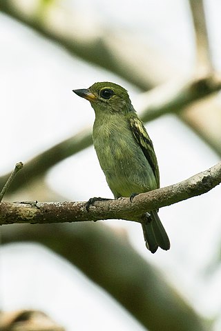
The green tinkerbird is a species of bird in the Lybiidae family . It is found in Kenya, Malawi, Mozambique, and Tanzania.

<span class="mw-page-title-main">Tourism in Mozambique</span>

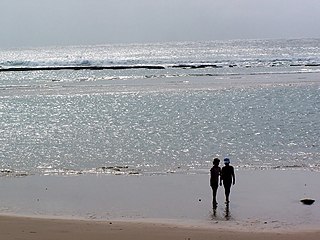
The tourism assets of Mozambique include the country's natural environment, wildlife, and cultural heritage, which provide opportunities for beach, cultural, and eco-tourism.

<span class="mw-page-title-main">Southern Zanzibar–Inhambane coastal forest mosaic</span> Tropical moist broadleaf forest ecoregion of eastern Africa

The Southern Zanzibar–Inhambane coastal forest mosaic, also known as the Southern Swahili coastal forests and woodlands, is a tropical moist broadleaf forest ecoregion of eastern Africa. It is a southern variation of Northern Zanzibar-Inhambane coastal forest mosaic. The ecoregion supports habitats of forest, savanna and swamps. The southern portion of the ecoregion is not as well studied due to the 1977-1992 civil war in Mozambique.

Maputo Special Reserve is a nature reserve in Mozambique.

<span class="mw-page-title-main">East African mangroves</span> Mangrove swamps on the Indian Ocean coast of East Africa

The East African mangroves are a mangrove ecoregion consisting of swamps along the Indian Ocean coast of East Africa in Mozambique, Tanzania, Kenya and southern Somalia.

<span class="mw-page-title-main">Maputaland-Pondoland-Albany Hotspot</span> Southern Africa biodiversity hotspot

The Maputaland-Pondoland-Albany Hotspot (MPA) is a biodiversity hotspot, a biogeographic region with significant levels of biodiversity, in Southern Africa. It is situated near the south-eastern coast of Africa, occupying an area between the Great Escarpment and the Indian Ocean. The area is named after Maputaland, Pondoland and Albany. It stretches from the Albany Centre of Plant Endemism in the Eastern Cape Province of South Africa, through the Pondoland Centre of Plant Endemism and KwaZulu-Natal Province, the eastern side of Eswatini and into southern Mozambique and Mpumalanga. The Maputaland Centre of Plant Endemism is contained in northern KwaZulu-Natal and southern Mozambique.

<span class="mw-page-title-main">Maputaland</span> Natural region in South Africa in northern KwaZulu-Natal

Maputaland is a natural region of Southern Africa. It is located in the northern part of the province of KwaZulu-Natal, South Africa between Eswatini and the coast. In a wider sense it may also include the southernmost region of Mozambique. The bird routes and coral reefs off the coast are major tourist attractions.

<span class="mw-page-title-main">Zambezian and mopane woodlands</span> Tropical and subtropical grasslands, savannas, and shrublands ecoregion of southeastern Africa.

The Zambezian and mopane woodlands is a tropical and subtropical grasslands, savannas, and shrublands ecoregion of southeastern Africa.

The Peace Park Foundation, founded in 1997 by Dr Anton Rupert, President Nelson Mandela and Prince Bernhard of the Netherlands, is an organisation that aims to re-establish, renew and conserve large ecosystems in Africa, transcending man-made boundaries by creating regionally integrated and sustainably managed networks of Transfrontier Conservation Areas (TFCAs). Peace Parks Foundation has been involved in the establishment and development of ten of the 18 TFCAs found throughout southern Africa, all of which are in various stages of development. The establishment of each TFCA, or peace park, is complex and far-reaching, and involves several phases of activity, which can take many years to achieve.

<span class="mw-page-title-main">Delagoa</span> Marine ecoregion on the eastern coast of southern Africa

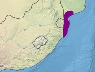
Delagoa is a marine ecoregion along the eastern coast of Africa. It extends along the coast of Mozambique and South Africa from the Bazaruto Archipelago to Lake St. Lucia in South Africa in South Africa's Kwazulu-Natal province. It adjoins the Bight of Sofala/Swamp Coast ecoregion to the north, and the Natal ecoregion to the south. It has Africa's southernmost tropical coral reefs and mangrove forests. It is the southernmost Indo-Pacific ecoregion, marking the transition from the tropical Indo-Pacific to Temperate Southern Africa.

Mozambique has abundant energy sources available for exploitation. As of 2021, the country was ranked first in energy potential of all the countries in the Southern African Power Pool (SAPP), with an estimated energy capacity of 187,000 MW. Available energy sources include coal, hydroelectricity, natural gas, solar energy and wind power. As of September 2021, the largest proportion of the power currently generated is from hydroelectric sources. However the energy mix in the country is changing. Natural gas powered energy stations are expected to provide 44 percent of total energy generation from 2020 to 2030.

References

  1. 1 2 Philip's (1994). Atlas of the World. Reed International. pp. 105–107. ISBN   0-540-05831-9.
  2. "Climate: Mozambique". Climates to Travel. Retrieved 19 July 2019.
  3. Butler, Rhett A. (1 July 2019). "Total number of plant species by country". Mongabay. Retrieved 13 July 2019.
  4. 1 2 3 4 5 6 Briggs, Philip; Connolly, Sean (2014). Mozambique. Bradt Travel Guides. pp. 27–32. ISBN   978-1-84162-496-9.
  5. "Maputaland-Pondoland-Albany". Biodiversity hotspots. Conservation International. Archived from the original on 23 March 2010. Retrieved 15 July 2019.
  6. The World's Mangroves, 1980-2005: A Thematic Study in the Framework of the Global Forest Resources Assessment 2005. Food and Agriculture Organization of the United Nations. 2007. pp. 15–17. ISBN   978-92-5-105856-5.
  7. Butler, Rhett A. (1 July 2019). "Total number of mammal species by country". Mongabay. Retrieved 13 July 2019.
  8. 1 2 This information is derived from the IUCN Red List which lists species of mammals and their distributions.
  9. Lepage, Denis (2019). "Mozambique". Avibase: Bird Checklists of the World. Retrieved 14 July 2019.
  10. Wheatley, Nigel (2014). Where to Watch Birds in Africa. Princeton University Press. pp. 253–254. ISBN   978-1-4008-6428-7.
  11. Butler, Rhett A. (1 July 2019). "Total number of reptile species, by country". Mongabay. Retrieved 13 July 2019.
  12. Butler, Rhett A. (1 July 2019). "Total number of amphibian species, by country". Mongabay. Retrieved 13 July 2019.
  13. Muratov I. V. (2010). "Terrestrial molluscs of Cabo Delgado and adjacent inland areas of north-eastern Mozambique". African Invertebrates 51 (2): 255-288. abstract.
  14. 1 2 Sawe, Benjamin Elisha (25 April 2017). "National Parks and Reserves in Mozambique". World Atlas. Worldatlas.com. Retrieved 19 July 2019.
  15. Parque Nacional de Banhine
  16. "The Bazaruto National Park". Mozambique Ministry of Tourism. Archived from the original on 2008-11-21. Retrieved 2011-10-16.
  17. Parque Nacional da Gorongosa
  18. Parque Nacional do Limpopo Archived 2009-05-20 at the Portuguese Web Archive
  19. Jackson, Jinty (20 October 2013). "Amid the coal mines, Mozambique stakes out game park". Mail & Guardian. Retrieved 19 July 2019.
  20. "Quirimbas National Park, Mozambique". WWF. Archived from the original on 17 February 2012. Retrieved 17 October 2011.
  21. Parque Nacional do Zinave
  22. Reserva Nacional do Chimanimani
  23. Reserva Especial de Maputo
  24. Reserva Nacional do Niassa