York Road tube station

Last updated

York Road
York Road station.jpg
York Road tube station in 2008
Islington London UK location map.svg
Red pog.svg
York Road
Location of York Road in London Borough of Islington
Location King's Cross
Local authority Metropolitan Borough of Islington
Owner Great Northern, Piccadilly and Brompton Railway
Number of platforms2
Key dates
15 December 1906 (1906-12-15)Opened
19 September 1932 (1932-09-19)Closed
Other information
WGS84 51°32′18″N0°07′21″W / 51.53833°N 0.12250°W / 51.53833; -0.12250
Underground sign at Westminster.jpg  London transportportal

York Road is a disused station on the London Underground in Kings Cross, London, England, located between King's Cross and Caledonian Road, with its entrance at the corner of York Road (now York Way) and Bingfield Street.

Contents

It opened in 1906 and was one of the original stations on the Great Northern, Piccadilly and Brompton Railway (GNP&BR), the precursor to today's Piccadilly line. The surface buildings were constructed in the distinctive style of architect Leslie Green, and were connected to the platforms by a single lift shaft containing two lifts. Traffic levels were never high, and the station closed in 1932, on the same day that the northern extension of the Piccadilly Line from Finsbury Park to Arnos Grove opened.

London Transport Museum runs regular Zoom-hosted tours of the station through its "Hidden London" programme. The tour features original elements of the station including the tiled lift lobby and signal cabin and it explores the modifications that were made to the station over the years. [1]

Description

York Road station was located at the junction between York Road, which has since been renamed York Way, and Bingfield Street. The architect Leslie Green designed the building, which was similar to many of his designs, being finished in ruby-red glazed tiling supplied by the Leeds Fireclay Company. The contract for construction was awarded to Ford and Walton, and the booking hall was at the surface level. It was linked to the platforms by a circular lift shaft, 23 feet (7.0 m) in diameter, which contained two electric lifts; there was also a staircase for emergency use. The lifts were manufactured by the Otis Elevator Company, and Colonel H A Yorke, who inspected the station at the time of its opening on behalf of the Board of Trade, recorded that they rose 89.49 feet (27.28 m) from the platform level to the booking hall level. [2]

Unlike most other Great Northern, Piccadilly & Brompton Railway stations, where the lifts stopped at a mezzanine level a little above the platforms, and required passengers to descend a final flight of stairs to reach the trains, the lifts at York Road descended directly to platform level. This meant that the platforms were further apart, and the interconnecting passages were longer as a result. The eastbound platform was 350 feet (110 m) long, while the westbound platform was slightly longer. [2] The platform layout was almost identical to that at Caledonian Road, but the two tracks curved outwards in the middle of the station to accommodate the extra width of the lift shaft bases. [3]

The platform tiling was carried out by George Woolliscroft & Son of Hanley, Staffordshire, and was made up of white with maroon and brick red patterning. Most of the tiling has since been painted over in grey, but a small section remains untouched and can be seen at the Finsbury Park end of the former eastbound platform. The station was ventilated by a fan, which drew air out of the station at a rate of 18,500 cubic feet (520 m3) per minute. [4]

A small signalling cabin stands near the unpainted tiling, and was used to operate a crossover immediately to the northeast of the station. This signal box remained operational until 25 April 1964, although by that time the crossover was little used, having been largely superseded by a new one commissioned at King's Cross on 25 November 1956. However, the disused cabin still stands and can be seen from passing trains. [4]

Being sited in a poor industrial area, the station saw little use, and from October 1909, some trains did not stop at the platforms, in order to improve service times to the other stations. The Sunday services were withdrawn entirely from 5 May 1918. The station remained open for weekday and Saturday traffic only, and closed on 4 May 1926, when the general strike began. Although the strike only lasted for nine days, the station remained closed. However the subject of its closure was eventually raised in the House of Commons, and it reopened in October 1926, but the reprieve was short-lived, lasting until 19 September 1932 when it was permanently closed. [5] The closure occurred on the same day as the northern extension of the Piccadilly Line from Finsbury Park to Arnos Grove opened. [6]

The surface station buildings are still clearly visible, on the left heading south down York Way towards King's Cross. They were used by the Victor Printing Company following closure, but eventually became derelict. They were refurbished in 1989, when the removal of boards covering the facade enabled the original lettering to be seen once again. The former platform area below is also visible from passing trains in both directions, although part of the eastbound platform is bricked off. As with most other disused Underground stations, the platform itself has been removed. [5] As the site is currently used as an emergency exit from the tunnels, one of the passageways between the platforms is permanently lit by a series of lamps.

Proposed reopening

One of London's largest redevelopment projects, King's Cross Central, began construction in 2008 across the road from the station. Islington council and Transport for London (TfL) commissioned a study in 2005 to consider the possible reopening of the station. At the same time, however, it was recognised that other transport priorities reduced the likelihood of such a project moving forward in the near future. The site would need extensive overhauls to bring the station up to modern day standards, at a cost estimated at £21 million in 2005. Local political groups have been keen to see the station reopened in order to reduce passenger congestion at King's Cross St. Pancras and to encourage development in the surrounding community. The Liberal Democrats advocated the reopening of the station in their 2006 local election manifesto, and at least one candidate for the Conservative Party similarly campaigned for the station to be reopened. [7] [8] [9] [10]

In June 2017, the council and Transport for London were reportedly discussing the possible reopening of Maiden Lane overground and York Road underground stations. The reopening of Maiden Lane was considered to be more likely, as York Road is quite close to Kings Cross St Pancras, and the new station would increase journey times on the Piccadilly line. [11]

Related Research Articles

<span class="mw-page-title-main">Piccadilly line</span> London Underground line

The Piccadilly line is a deep-level London Underground line running from the north to the west of London. It has two branches, which split at Acton Town, and serves 53 stations. The line serves Heathrow Airport, and some of its stations are near tourist attractions such as Piccadilly Circus and Buckingham Palace. The District and Metropolitan lines share some sections of track with the Piccadilly line. Printed in dark blue on the Tube map, it is the fourth busiest line on the Underground network, with over 210 million passenger journeys in 2011/12.

<span class="mw-page-title-main">Aldwych tube station</span> London Underground station, 1907–1994

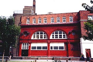
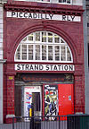
Aldwych is a closed station on the London Underground, located in the City of Westminster in Central London. It was opened in 1907 with the name Strand, after the street on which it is located. It was the terminus of the short Piccadilly line branch from Holborn that was a relic of the merger of two railway schemes. The station building is close to the Strand's junction with Surrey Street, near Aldwych. During its lifetime, the branch was the subject of a number of unrealised extension proposals that would have seen the tunnels through the station extended southwards, usually to Waterloo.

<span class="mw-page-title-main">Holborn tube station</span> London Underground station

Holborn is a London Underground station in Holborn, Central London, located at the junction of High Holborn and Kingsway. It is served by the Central and Piccadilly lines. On the Central line the station is between Tottenham Court Road and Chancery Lane stations; on the Piccadilly line it is between Covent Garden and Russell Square and is in Travelcard Zone 1. Close by are the British Museum, Lincoln's Inn Fields, Red Lion Square, Bloomsbury Square, London School of Economics and Sir John Soane's Museum.

<span class="mw-page-title-main">Finsbury Park station</span> London Underground and railway station

Finsbury Park is an intermodal interchange station in North London. It serves a number of National Rail, London Underground and bus services. The station is the third busiest Underground station outside Zone 1, with over 33 million passengers using the station in 2019.

<span class="mw-page-title-main">King's Cross St Pancras tube station</span> London Underground station

King's Cross St Pancras is a London Underground station on Euston Road in the Borough of Camden, Central London. It serves King's Cross and St Pancras main line stations in fare zone 1, and is an interchange between six Underground lines. The station was one of the first to open on the network. As of 2021, it is the most used station on the network for passenger entrances and exits combined.

<span class="mw-page-title-main">Highbury & Islington station</span> London Underground and railway station

Highbury & Islington is a London Underground and National Rail interchange station in the London Borough of Islington, north London. It is served by the London Underground's Victoria line and the Great Northern's Northern City Line, as well as the London Overground's East and North London Lines.

<span class="mw-page-title-main">Green Park tube station</span> London Underground station

Green Park is a London Underground station located on the edge of Green Park, with entrances on both sides of Piccadilly. It is served by the Jubilee, Piccadilly and Victoria lines. On the Jubilee line it is between Bond Street and Westminster; on the Piccadilly line it is between Piccadilly Circus and Hyde Park Corner and on the Victoria line it is between Victoria and Oxford Circus. It is in fare zone 1.

<span class="mw-page-title-main">King's Cross Thameslink railway station</span> Former Thameslink and Metropolitan Railway Station in Central London

King's Cross Thameslink station is a closed railway station in central London, England. It is located on Pentonville Road, around 250 metres (0.2 mi) east of King's Cross mainline station. At the time of closure, in 2007, it was served by Thameslink trains and managed by First Capital Connect. Services have been transferred to a new station underneath St Pancras.

<span class="mw-page-title-main">South Kensington tube station</span> London Underground station

South Kensington is a London Underground station in the district of South Kensington, south west London. It is served by the District, Circle and Piccadilly lines. On the District and Circle lines it is between Gloucester Road and Sloane Square, and on the Piccadilly line between Gloucester Road and Knightsbridge. It is in Travelcard Zone 1. The main station entrance is located at the junction of Old Brompton Road (A3218), Thurloe Place, Harrington Road, Onslow Place and Pelham Street. Subsidiary entrances are located in Exhibition Road giving access by pedestrian tunnel to the Natural History, Science and Victoria and Albert Museums. Also close by are the Royal Albert Hall, Imperial College London, the Royal College of Music, the London branch of the Goethe-Institut and the Ismaili Centre.

<span class="mw-page-title-main">Euston tube station</span> London Underground station

Euston is a London Underground station. It directly connects with Euston main line station above it. The station is in Travelcard Zone 1.

<span class="mw-page-title-main">Angel tube station</span> London Underground station

Angel is a London Underground station in the Angel area of the London Borough of Islington. It is on the Bank branch of the Northern line, between King's Cross St. Pancras and Old Street stations, in Travelcard Zone 1. The station was originally built by the City & South London Railway (C&SLR) and opened on 17 November 1901. The station served as a terminus until the line was extended to Euston on 12 May 1907.

<span class="mw-page-title-main">Covent Garden tube station</span> London Underground station

Covent Garden is a London Underground station serving Covent Garden and the surrounding area in the West End of London. It is on the Piccadilly line between Leicester Square and Holborn stations and is in Travelcard Zone 1. The station is at the corner of Long Acre and James Street and the street-level concourse is a Grade II listed building.

<span class="mw-page-title-main">Gloucester Road tube station</span> London Underground station

Gloucester Road is a London Underground station in Kensington, west London. The station entrance is located close to the junction of Gloucester Road and Cromwell Road. Close by are the Cromwell Hospital and Baden-Powell House.

<span class="mw-page-title-main">Russell Square tube station</span> London Underground station

Russell Square is a London Underground station opposite Russell Square on Bernard Street, Bloomsbury, in the London Borough of Camden. The station is on the Piccadilly line, between Holborn and King's Cross St Pancras and is in Travelcard Zone 1.

<span class="mw-page-title-main">Down Street tube station</span> Closed London Underground station

Down Street, also known as Down Street (Mayfair), is a disused station on the London Underground, located in Mayfair, west London. The Great Northern, Piccadilly and Brompton Railway opened it in 1907. It was latterly served by the Piccadilly line and was situated between Dover Street (now named Green Park) and Hyde Park Corner stations.

<span class="mw-page-title-main">Brompton Road tube station</span> Closed London Underground station

Brompton Road is a disused station on the Piccadilly line of the London Underground, located between Knightsbridge and South Kensington stations.

<span class="mw-page-title-main">South Harrow tube station</span> London Underground station

South Harrow is a London Underground station on the Uxbridge branch of the Piccadilly line. It is between Rayners Lane and Sudbury Hill stations. It is located on Northolt Road (A312). The station is in Travelcard Zone 5. There are several bus stands outside the station as well as overnight train stabling sidings.

<span class="mw-page-title-main">Holloway Road tube station</span> London Underground station

Holloway Road is a station on the London Underground. It is on the Piccadilly line between Caledonian Road and Arsenal stations, and in Travelcard Zone 2. The station opened on 15 December 1906.

<span class="mw-page-title-main">Caledonian Road tube station</span> London Underground station

Caledonian Road is a station on the Piccadilly line of the London Underground, between King's Cross St. Pancras and Holloway Road, and in Travelcard Zone 2. It was opened on 15 December 1906 by the Great Northern, Piccadilly and Brompton Railway. The building was designed by Leslie Green.

<span class="mw-page-title-main">Great Northern, Piccadilly and Brompton Railway</span> Underground railway company in London

The Great Northern, Piccadilly and Brompton Railway (GNP&BR), also known as the Piccadilly tube, was a railway company established in 1902 that constructed a deep-level underground "tube" railway in London, England. The GNP&BR was formed through a merger of two older companies, the Brompton and Piccadilly Circus Railway (B&PCR) and the Great Northern and Strand Railway (GN&SR). It also incorporated part of a tube route planned by a third company, the District Railway (DR). The combined company was a subsidiary of the Underground Electric Railways Company of London (UERL).

References

  1. "York Road virtual tour". London Transport Museum. Retrieved 10 February 2023.
  2. 1 2 Connor 1999, p. 67.
  3. "Plans of platform and surface buildings". London Transport Museum. Retrieved 12 November 2018.
  4. 1 2 Connor 1999, pp. 67–68.
  5. 1 2 Connor 1999, p. 68.
  6. Lee 1966, p. 22.
  7. "Kings Cross Central" (PDF). London Borough of islington. December 2005. Archived from the original (PDF) on 5 May 2006.
  8. Fox, Bridget. "Better Transport for Islington". Archived from the original on 8 June 2009.
  9. "Islington". Islington Conservatives. Archived from the original on 12 December 2007.
  10. "York Road Station Re-opening - Business Case Analysis" (PDF). Halcrow Group Limited. March 2005. p. 6. Archived from the original (PDF) on 13 July 2011. The objective would be to ensure that public transport users travelling from the KCC development would benefit from travelling via York Road Station rather than using King's Cross St Pancras Station. This in turn leads to the subobjective of providing congestion relief for King's Cross St Pancras Station.
  11. Finch 2017, p. 1.

Bibliography

Preceding station Underground no-text.svg London Underground Following station
King's Cross St Pancras
towards South Harrow
Piccadilly line Caledonian Road
towards Finsbury Park