Hog's Back

Last updated

Hog's Back
Looking east along the Hog's Back towards Guildford.jpg
Aerial photograph of the Hog's Back, looking east towards Guildford. The A31 dual carriageway runs along the spine of the ridge.
Highest point
Elevation 154 m (505 ft)
Coordinates 51°13′36″N0°38′36″W / 51.22667°N 0.64333°W / 51.22667; -0.64333
Geography
Surrey UK relief location map.jpg
Red triangle with thick white border.svg
Hog's Back
The Hog's Back in Surrey, England
Parent range North Downs

The Hog's Back is a hilly ridge, part of the North Downs in Surrey, England. It runs between Farnham in the west and Guildford in the east.

Contents

Name

Compared with the main part of the Downs to the east of it, it is a narrow elongated ridge, hence its name.

Jane Austen, in a letter to her sister Cassandra dated Thursday 20 May 1813 from her brother's house in Sloane Street, wrote of her journey to London in a curricle via "the Hog's-back"

"Upon the whole it was an excellent journey & very thoroughly enjoyed by me; the weather was delightful the greatest part of the day. ... I never saw the country from the Hogsback so advantageously."

This shows that it was known as the Hog's Back by Jane Austen's time. However, the medieval name for the ridge was Guildown (recorded first in 1035 where it was the site of the abduction of Prince Alfred of Wessex by Earl Godwin and then in the Pipe Rolls for 1190 and onwards) but this name is no longer in use. However, the name Guildown is evoked by Guildown Road, a residential road which climbs the southern side of the ridge on the southwestern fringes of Guildford.

The Guild- element of Guildown is the same as that found in Guildford, meaning "gold". Various explanations have been suggested for the relationship between the names of Guildown and Guildford. Guildown may be an abbreviation of Guildford Down ("the Down by Guildford"). The Hog's Back ends at Guildford, which is the point where the River Wey cuts through the North Downs. Alternatively, both Guildown and Guildford may derive independently from a gold-coloured feature; either the yellow flowers of the marsh marigold or the gold-coloured (sandy) soil of the hillside. [1] [2]

Position

The Hog's Back seen from the North Downs Way at Puttenham. North downs way seen from puttenham.jpg
The Hog's Back seen from the North Downs Way at Puttenham.

The Hog's Back has a minimum prominence (drop) of 55 metres (180 ft), reaching 154 m (505 ft) above sea level, the 24th highest hill in Surrey. [3]

Along its course are half panoramas north and south separated by less than 100 m (330 ft) viewable from paths alongside the road which runs along the Hog's Back (the A31).

The view north includes many towns and villages, including Woking, Ash and Aldershot which on a clear day reaches to London, as far as Canary Wharf, Tower 42, The Gherkin, Wembley Arch and Heathrow Airport. The view to the south is unspoilt and has been designated an area of outstanding natural beauty as well as a site of special scientific interest. These views extend to Hindhead and the Devil's Punchbowl.

Road

The road along the Hog's Back is ancient, since its raised position offered travellers a vantage point and also kept them above the thick ancient woodland of the valleys on either side. It was part of the ancient ridgeway which runs from Wiltshire down to the east coast of Kent.

It was also part of the road from London to Winchester (as it still is). Although there is very little archaeological evidence in support, it has been suggested that a Roman road ran from London to Winchester and that, at this point, it passed, either over the Hog's Back or perhaps a little to the north (e.g. Roman Surrey, David Bird, 2004). Research on this is continuing.

According to the Victoria County History of Surrey (volume 3, published 1911, p 374, s.v. Wanborough), the road over the Hog's Back was "the Via Regia of early deeds and Hundred Rolls".

What is now designated the A31 along the Hog's Back originally formed part of a road leading directly from Winchester into Guildford High Street and from there into London. However, the modern A31 adopts a slightly less direct and less steep approach to the High Street, and reorganisation of central Guildford into a roundabout road system centred on the Friary Centre (named after the medieval Dominican Friary there) has also broken up this direct stretch of road at the point that it reaches Guildford, where it ends at the junction with the A3.

When the idea of the Pilgrims' Way to Canterbury was popularised in the nineteenth century, a route over the southern slopes of the Hog's back, parallel with the ridgeway and running through Seale and Puttenham, was incorporated in its course. In order to avoid the A31, however, the Pilgrims' Way does not run along the top of the Hog's Back.

The Hog's Back stretch of the A31 is now a dual carriageway, but the two directions of the road are separated by a central area of trees, some of them very old. The original road ran along the stretch now occupied by the lanes running from Guildford to Farnham, i.e. from east to west. The other two lanes, running from west to east, which are a little below the high point occupied by the original carriageways, were added in the early 1970s.

Archaeology and Seven Ditches

Roughly midway along the ridge of the Hog’s Back between Farnham and Guildford (OS grid reference SU911483 [4] ), the human remains of at least six skeletons were discovered in 1935 when ground was being dug for a new water pipe. [5] They were buried less than a yard from the then-northern edge of the road (now part of the central grass verge between the two carriageways). [5] One of them was buried prone and another showed signs of having originally been bound or trussed, and scholars now believe that they were criminals buried here after execution at different times over an extended period (Reynolds in 2005; Briggs in 2010). [5] Their burial place was at the meeting point of the parishes of Wanborough, Seale (originally Farnham) and Puttenham, which were each in the different hundreds of Woking, Farnham and Godalming respectively. [5] It is suggested by Rob Briggs that an elevated site at the junction of different hundreds and parishes was probably a site of general assembly and he identifies it with the place name Seven Ditches, found in the charter of King Caedwalla of Wessex confirming Farnham to the Bishop of Winchester (following the original grant by King Edward the Elder in 909 AD) (Latin vii dica); and also in a feoffment defining the Shoelands estate in about 1210 (Latin “Seuedic”); and also in the plea rolls of the 1263 Surrey Eyre, noting the hanging of one Robert de la Felde of Send at (Latin) “Seinedik”, translated Sendike or Seven Ditches. [5]

Notable buildings

On the north side of the Hog's Back near the turn off to the village of Seale formerly stood a mansion known as Poyle Hill Lodge. This was once one of the Admiralty semaphore stations because of its high vantage point. In 1935 it became the Hog's Back Hotel, initially owned by the Guildford Friary Brewery, [6] and it remains a hotel, now officially known as the Hog's Back Hotel and Spa, Farnham.

On the south side of the Hog's Back, a little to the east of Poyle Hill, another large mansion was built in 1873 called Great Down, attributed to Robert Kerr. This was demolished in about 1950, but the parkland and other associated buildings, such as a lodge and stables, remain.

Also on the south side is Greyfriars House, a Grade II* listed Arts and Crafts style mansion built in 1896 by the renowned architect Charles Voysey. [7] It is now a boutique wedding venue. [8]

The Hogs Back Brewery is an independent real ale brewery based in Tongham, which is a village just below the Hog's Back.

The Hog's Back Cafe is in a layby on the Guildford to Farnham (westbound) carriageway of the A31 along the Hog's Back, between the turn offs to Puttenham and Seale. It is popular with lorry drivers, who use the cafe and toilets during the day. The hillside adjacent to the A31 layby was a popular site for dogging (viewing or participating in sexual relations in a public place), but recently (2012–13) Guildford police and local residents are curbing these practices. [9]

Towards Guildford, on the north-east side of the Hog’s Back, lie Down Place and Blackwell Farm. The manor of Down Place was demolished in 1963, [10] all that remains today of the estate are the stables where is established Hogs Back Books, the children’s book publisher.
Once associated with the manor as one of the first model farm in Surrey, [11] Blackwell Farm is now a place of controversies since the University of Surrey, its owner, announced its plan to build a "Garden Neighbourhood" as part of Guildford Borough Council's local plan consultation. [12]

Geology

The Hog's Back is formed of chalk of Cretaceous age, laid down in shallow seas from the deposition of the calcium carbonate skeletons of micro-organisms. The Hog's Back is the surface representation of a monoclinal fold, where once horizontal chalk beds have been folded into steeply sloping layers. Across much of the North Downs, the angle of the chalk as it disappears below the surface is relatively shallow (c. 18° near Dorking), however at the Hog's Back, local faulting has produced a much steeper angle (up to 55°). [13] To the north of the ridge lies the London Clay, and to the south the clays of the Wealden Group. The chalk is more resistant to weathering than the flanking clays, leading to the ridge's prominence over the surrounding terrain. [14]

The Hog's Back gives its name to the geomorphological landform known as a Hogback, which is a long narrow ridge or series of hills with a narrow crest and steep slopes of nearly equal inclination on both flanks. [15]

The Hog's Back is mentioned in:

Related Research Articles

<span class="mw-page-title-main">Surrey</span> County of England

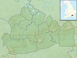
Surrey is a ceremonial county in South East England. It is bordered by Greater London to the north east, Kent to the east, East and West Sussex to the south, and Hampshire and Berkshire to the west. The largest settlement is Woking.

<span class="mw-page-title-main">Farnham</span> Market town in Surrey, England

Farnham is a market town and civil parish in Surrey, England, around 36 miles (58 km) southwest of London. It is in the Borough of Waverley, close to the county border with Hampshire. The town is on the north branch of the River Wey, a tributary of the Thames, and is at the western end of the North Downs. The civil parish, which includes the villages of Badshot Lea, Hale and Wrecclesham, covers 14.1 sq mi (37 km2) and had a population of 39,488 in 2011.

<span class="mw-page-title-main">North Downs Way</span> Long-distance footpath in the south of England

The North Downs Way National Trail is a long-distance path in southern England, opened in 1978. It runs from Farnham to Dover, past Guildford, Dorking, Merstham, Otford and Rochester, along the Surrey Hills Area of Outstanding Natural Beauty (AONB) and Kent Downs AONB.

<span class="mw-page-title-main">North Downs</span> Range of hills in south east England, UK

The North Downs are a ridge of chalk hills in south east England that stretch from Farnham in Surrey to the White Cliffs of Dover in Kent. Much of the North Downs comprises two Areas of Outstanding Natural Beauty (AONBs): the Surrey Hills and the Kent Downs. The North Downs Way National Trail runs along the North Downs from Farnham to Dover.

<span class="mw-page-title-main">A25 road</span> Road in southern England

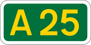
The A25 road is an east–west main road in the South-East of England. Its carries traffic east from Guildford, Surrey, eastward through Surrey and into mid-west Kent, to the town of Sevenoaks, and then on to Wrotham Heath where it connects with the A20.

<span class="mw-page-title-main">A31 road</span> Major trunk road in southern England

The A31 is a major trunk road in southern England that runs from Guildford in Surrey to Bere Regis in Dorset. Its most well known section is the Hog's Back, a hilly ridge forming part of the North Downs, in the Surrey stretch between Guildford and Farnham.

<span class="mw-page-title-main">Borough of Guildford</span> Borough and Non-metropolitan district in England

The Borough of Guildford is a local government district with borough status in Surrey, England. With around half of the borough's population, Guildford is its largest settlement and only town, and is the location of the council.

<span class="mw-page-title-main">Pilgrims' Way</span> Historic walking route in England

The Pilgrims' Way is the historical route supposedly taken by pilgrims from Winchester in Hampshire, England, to the shrine of Thomas Becket at Canterbury in Kent. This name, of comparatively recent coinage, is applied to a pre-existing ancient trackway dated by archaeological finds to 600–450 BC, but probably in existence since the Stone Age. The prehistoric route followed the "natural causeway" east to west on the southern slopes of the North Downs.

<span class="mw-page-title-main">Artington</span> Human settlement in England

Artington is a village and civil parish in the borough of Guildford, Surrey, England. It covers the area from the southern edge of the built-up centre of Guildford and steep Guildown, the start of the Hog's Back and part of the North Downs AONB, to New Pond Farm by Godalming and the edge of Peasmarsh. It contains Loseley Park, a country estate with dairy, and the hamlet of Littleton.

<span class="mw-page-title-main">Mount Cemetery</span> Cemetery in Surrey, England

Mount Cemetery, also known as Guildford Cemetery, is a cemetery in Guildford, Surrey, England. It is the location of Booker's Tower.

<span class="mw-page-title-main">Harrow Way</span> Ancient trackway

The Harrow Way is another name for the "Old Way", an ancient trackway in the south of England, dated by archaeological finds to 600–450 BC, but probably in existence since the Stone Age. The Old Way ran from Seaton in Devon to Dover, Kent. Later the eastern part of the Harrow Way become known as the Pilgrims' Way in the 19th century: the latter was a route invented by Albert Way of the Ordnance Survey, who imagined it to have been a pilgrimage route which ran from Winchester, Hampshire, via Farnham, Surrey, to Canterbury Kent. The western section of the Harrow Way ends in Farnham, the eastern in Dover.

<span class="mw-page-title-main">Normandy, Surrey</span> Human settlement in England

Normandy is a civil parish of 16.37 square kilometres in the borough of Guildford in Surrey, England and the name of the largest village in that parish. Almost surrounded by its hill ranges, Normandy is in the plain west of Guildford, straddles the A323 'Aldershot Road' and is north of the narrowest part the North Downs known as the Hog's Back which carries a dual carriageway. The parish in 2011 had a population of 2,981 living in 1,310 households, has woods, a public common and four government-operated commons to the north that are an SSSI heath. Normandy has been home to a number of notable residents, including William Cobbett.

<span class="mw-page-title-main">Wanborough, Surrey</span> Human settlement in England

Wanborough is a rural village and civil parish in Surrey approximately 4 miles (6 km) west of Guildford on the northern slopes of the Hog's Back. Wanborough lies between Puttenham and Normandy. Wanborough village grew around and to service Wanborough Manor which is on the site of ancient springs.

<span class="mw-page-title-main">Puttenham, Surrey</span> Human settlement in England

Puttenham is a village in Surrey, England, located just south of the Hog's Back which is the narrowest stretch of the North Downs. Puttenham is about midway between the towns of Guildford and Farnham, and can be accessed from the A31 trunk road which runs along the spine of the Hog's Back. Villages nearby include Wanborough, Shackleford and Compton.

<span class="mw-page-title-main">Tongham</span> Village in England

Tongham is a village northeast of the town of Farnham in Surrey, England. The village's buildings occupy most of the west of the civil parish, adjoining the A31 and the A331. The boundaries take in Poyle Park in the east and the replacement to Runfold's manor house in the west.

<span class="mw-page-title-main">Seale, Surrey</span> Village in England

Seale is a village in Surrey, England. Seale covers most of the civil parish of Seale and Sands and the steep slope and foot of the south side of the Hog's Back as well as a large hill which exceeds it – as such is part of the Surrey Hills Area of Outstanding Natural Beauty.

<span class="mw-page-title-main">Vale of Holmesdale</span>

Holmesdale, also known as the Vale of Holmesdale, is a valley in South-East England that falls between the hill ranges of the North Downs and the Greensand Ridge of the Weald, in the counties of Kent and Surrey. It stretches from Folkestone on the Kent coast, through Ashford, Harrietsham, Maidstone, Riverhead/Sevenoaks, Westerham, Oxted, Godstone, Redhill, Reigate, Dorking, Gomshall, and Guildford – west of which it is also called by the local name of "Puttenham Vale" – as it continues through the village of Puttenham, to the market town of Farnham.

National Cycle Route 22 (NCR22) runs from Banstead to Brockenhurst in the New Forest via Dorking, Guildford, Farnham, Petersfield, Havant, Portsmouth, Ryde, Yarmouth and Lymington. Due to the route going over the Isle of Wight, ferry connections are required from Portsmouth to Ryde, and again from Yarmouth to Lymington.

<span class="mw-page-title-main">Geology of Surrey</span>

The geology of Surrey is dominated by sedimentary strata from the Cretaceous, overlaid by clay and superficial deposits from the Cenozoic.

References

  1. E. Ekwall (1960). The Concise Oxford Dictionary of English Place-Names (4th ed.). Guildford and Hog's Back
  2. A. D. Mills (1995) [1st imprint 1991]. A Dictionary of English Place Names. Guildford and Hog's Back
  3. Database of British and Irish Hills Retrieved 2015-03-06
  4. "OS grid reference SU911483 on Streetmaps" . Retrieved 21 January 2011.
  5. 1 2 3 4 5 Briggs, Rob (October 2010). "Six Skeletons at Seven Ditches". Bulletin 423; Surrey Archaeological Society: 6–9.
  6. Holmes, Thomas William (1983). The Semaphore. p. 201.
  7. Historic England. "Greyfriars, Wanborough, Hog's Back (1029612)". National Heritage List for England .
  8. "Greyfriars House" . Retrieved 1 August 2020.
  9. Lyall, Sarah (7 October 2010). "Here's the Pub, Church and Field for Public Sex". The New York Times.
  10. Gorton, Philip (2005). Notes on the history of Blackwell House.Compton, Surrey (Technical report). Domestic Building Research Group.
  11. Nicholas, Roger (2008). The Diaries of Henry Peak. p. 94.
  12. Watkins, James (6 December 2013). "Hog's Back group 'staggered' by scale of university homes plan". Surrey Advertiser.
  13. Lake RD, Shephard-Thorn ER (1985). "The stratigraphy and geological structure of the Hog's Back, Surrey and adjoining areas". Proceedings of the Geologists' Association. 96 (1): 7–21. doi:10.1016/S0016-7878(85)80011-0.
  14. "British Geological Survey, England and Wales Sheet 285, Guildford". www.largeimages.bgs.ac.uk. 2001. Retrieved 20 April 2017.
  15. Huggett, JR (2011) Fundamentals of Geomorphology, 3rd ed., Routledge, New York. 516 pp. ISBN   978-0415567756
  16. Freeman Wills Crofts. (16 October 2000). The Hog's Back Mystery. ISBN   1-84232-396-2.