
Lady's Bridge is the oldest bridge across the River Don in the City of Sheffield, England. It is located in the central section of the city, linking the Wicker to the north with Waingate to the south.
Lady's Bridge is the oldest bridge across the River Don in the City of Sheffield, England. It is located in the central section of the city, linking the Wicker to the north with Waingate to the south.
The original wooden bridge at this point was constructed close to Sheffield Castle sometime after 1150 under the orders of William de Lovetot, the Norman baron who had also built the castle along with the town's first church, hospital (at Spital Hill), and corn mill (at Millsands).
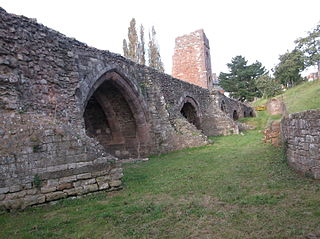
In 1485 the Vicar of Sheffield, Sir John Plesaunce, and William Hill, who was a master mason, both agreed to build a bridge of stone "over the watyr of Dune neghe the castell of Sheffeld" [1] at a cost of about £67. The bridge had five arches, and was 14.5 feet (4.4 m) wide. [2] A small chapel, dedicated to the Virgin Mary, was built close to the bridge, and the bridge became known as 'Our Lady's Bridge'. When built it could only be crossed by pedestrians as there were steps at either end of the bridge. The chapel was converted for use as a wool warehouse in 1547, to prevent its demolition as part of the Dissolution of the Monasteries during the reign of Henry VIII, and was subsequently used as an Alms house. [2]

In 1760 the bridge was widened on the upstream side, and the Alms House (formerly the chapel to Our Lady) was demolished to make way for the new structure. [3] [4] The bridge was widened on the downstream side in 1864, virtually obscuring the remaining original structure from view, and again in 1909, to allow trams to cross the bridge. [2] It was restored in the late 20th century, and has been a Grade II listed structure since 1973. [5]
On the night of 11 March 1864 Lady's Bridge narrowly avoided destruction when the waters of the Great Sheffield Flood poured over it. Nearly every other bridge upstream in the path of the flood had been smashed by the waters and the debris that they carried. A contemporary account described the scene:
When the flood was at its height the scene on the Lady's Bridge at the top of the Wicker was most extraordinary. The water came rushing down between the buildings on each side with a force that made the Lady's Bridge quake and tremble. Against the bridge were piled up trees, logs of timber, broken furniture, and debris of every description. The light from street gas lamps revealed to spectators, of whom they were a good many, some of the horrors of the scene. The arches of the bridge were nearly choked by the accumulation of rubbish, and the impeded waters rose to a fearful height, breaking over the parapets of the bridge, and rushing across Mr. White's slate yard over the broad thoroughfare of the Wicker.
— Samuel Harrison, A Complete History of the Great Flood at Sheffield. [6]
During the 2007 United Kingdom floods, Sheffield was badly hit, and Lady's Bridge and the Wicker in particular. Lady's Bridge was overwhelmed with water as it, the Wicker and the Blonk Street Bridge were flooded, and Lady's Bridge itself was at one point reported to be in danger of collapse.

The River Don is a river in South Yorkshire and the East Riding of Yorkshire, England. It rises in the Pennines, west of Dunford Bridge, and flows for 69 miles (111 km) eastwards, through the Don Valley, via Penistone, Sheffield, Rotherham, Mexborough, Conisbrough, Doncaster and Stainforth. It originally joined the Trent, but was re-engineered by Cornelius Vermuyden as the Dutch River in the 1620s, and now joins the River Ouse at Goole. Don Valley is a UK parliamentary constituency near the Doncaster stretch of the river.

Low Bradfield is a village within the civil parish of Bradfield in South Yorkshire, England. It is situated within the boundary of the city of Sheffield in the upper part of the Loxley Valley, 6¼ miles west-northwest of the city centre and just inside the northeast boundary of the Peak District National Park. Low Bradfield and the surrounding area is noted for its attractive countryside which draws many visitors from the more urban parts of Sheffield. At weekends the village can become quite crowded, especially when there is a match on the village cricket pitch. Low Bradfield which stands in the shadow of Agden Reservoir has a sister village High Bradfield which is located at a higher altitude, ½ mile to the northeast. The two villages are joined by the steep Woodfall Lane.

The Great Sheffield Flood was a flood that devastated parts of Sheffield, England, on 11 March 1864, when the Dale Dyke Dam broke as its reservoir was being filled for the first time. At least 240 people died and more than 600 houses were damaged or destroyed by the flood. The immediate cause was a crack in the embankment, the cause of which was never determined. The dam's failure led to reforms in engineering practice, setting standards on specifics that needed to be met when constructing such large-scale structures. The dam was rebuilt in 1875.
Malin Bridge is a suburb of the city of Sheffield, England. It is located at grid reference SK325893 and stands 2+1⁄2 miles north-west of the city centre where the rivers Loxley and Rivelin meet. Malin Bridge is only a small district centred on the road bridge over the River Loxley which carries the B6076 road to Stannington ; it is surrounded by the suburbs of Hillsborough, Wisewood, Walkley and Stannington.
Wicker railway station was the first railway station to be built in Sheffield, England. It was to the north of the city centre, at the northern end of the Wicker, in the fork formed by Spital Hill and Savile Street. It was opened on 31 October 1838 as the southern terminus of the Sheffield and Rotherham Railway, which ran north to Rotherham Westgate railway station.

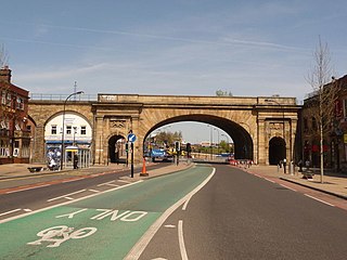
Wicker Arches form a 660-yard (600 m) long railway viaduct across the Don Valley in the City of Sheffield, England. They take their name from the thoroughfare Wicker, which passes through the main arch of the viaduct and was, until the completion of the Sheffield Parkway, the main route eastwards from the city to the M1. It is a Grade II* listed structure.
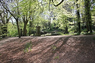
The General Cemetery in the City of Sheffield, England opened in 1836 and closed for burial in 1978. It was the principal cemetery in Victorian Sheffield with over 87,000 burials. Today it is a listed Landscape on the English Heritage National Register of Historic Parks and Gardens. It is also a Local Nature Reserve. It is owned by the City of Sheffield and managed on behalf of the city by a local community group, the Sheffield General Cemetery Trust.

William Edwards was a Welsh Methodist minister who also practised as a stonemason, architect and bridge engineer.
This timeline of Sheffield history summarises key events in the history of Sheffield, a city in England. The origins of the city can be traced back to the founding of a settlement in a clearing beside the River Sheaf in the second half of the 1st millennium AD. The area had seen human occupation since at least the last ice age, but significant growth in the settlements that are now incorporated into the city did not occur until the industrial revolution.

Transport in Sheffield, England is developed around the city's unusual topography and medieval street plan. Once an isolated town, the transport infrastructure changed dramatically in the 19th and 20th centuries. The city now has road and rail links with the rest of the country, and road, bus and trams for local transport.

Bridgehouses railway station was the terminal station of the Sheffield, Ashton-under-Lyne and Manchester Railway from its opening in 1845 until the opening of the Wicker Arches, a 660-yard (600 m) long viaduct across the Don Valley, which supported the new Sheffield Victoria opened on 15 September 1851. On 1 January 1847 a half-mile connecting line to the Wicker station of the Midland Railway had been constructed in order to increase goods traffic and enable wagon transfers. This short steeply graded line, enclosed within a tunnel for almost its entire length was known locally as the Fiery Jack.

Hillsborough Barracks is a walled complex of buildings between Langsett Road and Penistone Road in the Hillsborough District of Sheffield, South Yorkshire, England.

The River Don Navigation was the result of early efforts to make the River Don in South Yorkshire, England, navigable between Fishlake and Sheffield. The Dutch engineer Cornelius Vermuyden had re-routed the mouth of the river in 1626, to improve drainage, and the new works included provision for navigation, but the scheme did not solve the problem of flooding, and the Dutch River was cut in 1635 to link the new channel to Goole. The first Act of Parliament to improve navigation on the river was obtained in 1726, by a group of Cutlers based in Sheffield; the Corporation of Doncaster obtained an Act in the following year for improvements to the lower river. Locks and lock cuts were built and by 1751 the river was navigable to Tinsley.
The Wicker is an arterial street in Sheffield, England noted for its history and viaduct that crosses it, the Grade II* listed Wicker Arches. It runs in a north-east to south-westerly direction between Lady's Bridge and the Wicker Arches. For many years the Wicker was an A road, but it has been downgraded following the opening of the Sheffield Northern Relief Road.

Neepsend is a suburb of the city of Sheffield, it stands just 1 mile (1.6 km) north-west of the city centre. The main area of Neepsend covers the flood plain of the River Don from Lady's Bridge at the Wicker up to Hillfoot Bridge. The suburb falls within the Central Ward of the city. The adjacent district of Parkwood Springs is often regarded as part of the suburb.

The Green Lane Works are a disused industrial facility situated in the City of Sheffield, England. The entrance gate to the works is particularly ornate and has been designated as a Grade II* listed building. Nikolaus Pevsner called the gate “the most spectacular survival of factory architecture in the city”. The works are situated in the suburb of Neepsend within the Kelham Island Quarter of the city and date from 1795 although there were extensive alterations in 1860.

The Brooklyn Works is a former site of steel, saw and file manufacture, it is situated on Green Lane in the Kelham Island Quarter of the City of Sheffield, England. In recent years the works have been converted into residential apartments and offices. The structure is a Grade II listed building because of its importance as an example of Sheffield’s industrial heritage. The works stand adjacent to the listed industrial buildings of the Green Lane Works and Cornish Place in what has been called, “the most coherent stretch of industrial landscape in inner Sheffield”
The Old Exe Bridge is a ruined medieval arch bridge in Exeter in south-western England. Construction of the bridge began in 1190, and was completed by 1214. The bridge is the oldest surviving bridge of its size in England and the oldest bridge in Britain with a chapel still on it. It replaced several rudimentary crossings which had been in use sporadically since Roman times. The project was the idea of Nicholas and Walter Gervase, father and son and influential local merchants, who travelled the country to raise funds. No known records survive of the bridge's builders. The result was a bridge at least 590 feet long, which probably had 17 or 18 arches, carrying the road diagonally from the west gate of the city wall across the River Exe and its wide, marshy flood plain.
Hollis Hospital is an almshouse dating from 1703 in Sheffield, England.

Chantry Bridge, sometimes known as Wakefield Bridge, is a mediaeval bridge in the city of Wakefield, in West Yorkshire, in England.