
The San Francisco Municipal Railway ( MEW-nee; SF Muni or Muni), is the primary public transit system within San Francisco, California. It operates a system of bus routes, the Muni Metro light rail system, three historic cable car lines, and two historic streetcar lines. Previously an independent agency, the San Francisco Municipal Railway merged with two other agencies in 1999 to become the San Francisco Municipal Transportation Agency (SFMTA). In 2018, Muni served 46.7 square miles (121 km2) with an operating budget of about $1.2 billion. Muni is the seventh-highest-ridership transit system in the United States, with 114,721,200 rides in 2022, and the second-highest in California after the Los Angeles County Metropolitan Transportation Authority.
Muni Metro is a semi-metro system serving San Francisco, California, United States. Operated by the San Francisco Municipal Railway (Muni), a part of the San Francisco Municipal Transportation Agency (SFMTA), Muni Metro served an average of 68,700 passengers per weekday in the first quarter of 2023, making it the seventh-busiest light rail system in the United States.

The M Ocean View is a light rail line that is part of the Muni Metro system in San Francisco, California. Named after the Oceanview neighborhood, it runs between San Jose and Geneva and Embarcadero station, connecting Oceanview, San Francisco State University, and Stonestown Galleria with the city center. The line opened on October 6, 1925.

The K Ingleside is a hybrid light rail/streetcar line of the Muni Metro system in San Francisco, California. It mainly serves the West Portal and Ingleside neighborhoods. The line opened on February 3, 1918, and was the first line to use the Twin Peaks Tunnel.

The J Church is a hybrid light rail/streetcar line of the Muni Metro system in San Francisco, California. The line runs between Embarcadero station and Balboa Park station through Noe Valley. Opened on August 11, 1917, it is the oldest and has the lowest ridership of all of the Muni Metro lines.

Embarcadero station is a combined BART and Muni Metro rapid transit subway station in the Market Street subway in downtown San Francisco. Located under Market Street between Drumm Street and Beale Street near The Embarcadero, it serves the Financial District neighborhood and surrounding areas. The three-level station has a large fare mezzanine level, with separate platform levels for Muni Metro and BART below. Embarcadero station opened in May 1976 – almost two years after service began through the Transbay Tube – as an infill station.

Montgomery Street station is a combined BART and Muni Metro rapid transit subway station in the Market Street subway in downtown San Francisco. Located under Market Street between Montgomery Street and Sansome Street, it serves the Financial District neighborhood and surrounding areas. The three-level station has a large fare mezzanine level, with separate platform levels for Muni Metro and BART below. Montgomery Street and Embarcadero station to the north are typically the two busiest stations in the BART system.

Powell Street station is a combined BART and Muni Metro rapid transit station in the Market Street subway in downtown San Francisco. Located under Market Street between 4th Street and 5th Street, it serves the Financial District neighborhood and surrounding areas. The three-level station has a large fare mezzanine level, with separate platform levels for Muni Metro and BART below. The station is served by the BART Red, Yellow, Green Line, and Blue lines, and the Muni Metro J Church, K Ingleside, L Taraval, M Ocean View, N Judah, and S Shuttle lines.

The San Francisco trolleybus system forms part of the public transportation network serving San Francisco, in the state of California, United States. Opened on October 6, 1935, it presently comprises 15 lines and is operated by the San Francisco Municipal Railway, commonly known as Muni, with around 300 trolleybuses. In San Francisco, these vehicles are also known as "trolley coaches", a term that was the most common name for trolleybuses in the United States in the middle decades of the 20th century. In 2022, the system had a ridership of 33,664,000, or about 135,000 per weekday as of the third quarter of 2023.

33 Ashbury/18th Street is a trolleybus line operated by the San Francisco Municipal Railway. The route is descendant from the first trolleybus service to open in San Francisco.

1 California is a trolleybus line operated by the San Francisco Municipal Railway (Muni). It provides service between the Richmond District and Financial District along California Street.
41 Union is a trolleybus line operated by the San Francisco Municipal Railway (Muni). It connects South of Market, the Financial District, Chinatown, North Beach, Russian Hill, and Cow Hollow.

5 Fulton is a trolleybus line operated by the San Francisco Municipal Railway (Muni). It is one of several routes which connects the Outer Richmond to the Financial District.

31 Balboa is a trolleybus line operated by the San Francisco Municipal Railway. It is one of several routes operating between the Financial District and the Richmond District.

3 Jackson is a suspended trolleybus line operated by the San Francisco Municipal Railway.
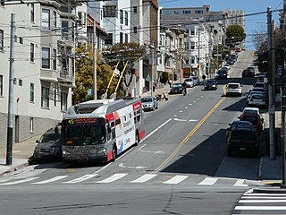
45 Union/Stockton is a trolleybus line operated by the San Francisco Municipal Railway. It connects Cow Hollow to South of Market via Russian Hill, Chinatown, and the Financial District.

19 Polk is a bus route operated by the San Francisco Municipal Railway (Muni). It runs from Ghirardelli Square in the north to Hunters Point in the south via Russian Hill, Nob Hill, the Tenderloin, South of Market, India Basin, and Potrero Hill.

29 Sunset is a bus line operated by the San Francisco Municipal Railway. The line connects the Richmond District and Sunset District to the city's southern neighborhoods through to the Bayview. It is a key cross-town route.

