
The River Dee is a river in Aberdeenshire, Scotland. It rises in the Cairngorms and flows through southern Aberdeenshire to reach the North Sea at Aberdeen. The area it passes through is known as Deeside, or Royal Deeside in the region between Braemar and Banchory because Queen Victoria came for a visit there in 1848 and greatly enjoyed herself. She and her husband, Prince Albert, built Balmoral Castle there, replacing an older castle.
Braemar is a village in Aberdeenshire, Scotland, around 58 miles (93 km) west of Aberdeen in the Highlands. It is the closest significantly-sized settlement to the upper course of the River Dee sitting at an elevation of 339 metres (1,112 ft).

The River Quoich is a tributary of the River Dee in Aberdeenshire, Scotland. It flows in a generally southerly direction and is about 15 km long. The clachan of Allanaquoich is situated just above the river's confluence with the Dee. Near Allanaquoich is the Linn of Quoich, a waterfall through a narrow ravine, over which there is a bridge at the narrowest part. Near the bridge is the Earl of Mar's Punch Bowl: a natural hole in a rock midstream that was literally used as a punchbowl after hunting deer in the neighbouring forest. The river joins the Dee about 11⁄2 miles or 21⁄2 km west of Braemar.

Swanston is a village and residential area on the southern edge of Edinburgh, Scotland, noted for its picturesque thatched cottages set around an informal village green. Because of its relatively isolated position at the foot of the Pentland Hills, it has remained largely unaffected by commercial or suburban development.
Finzean is a rural community, electoral polling district, community council area and former ecclesiastical parish, which forms the southern part of the Parish of Birse, Aberdeenshire, Scotland. Finzean was the subject of many well-known landscape paintings by the artist Joseph Farquharson, whose family have owned Finzean Estate since the 17th century. Finzean extends to approximately 8000 hectares in area and had a population of approximately 270 in 2002.

Mar Lodge is a sporting lodge 5 miles to the west of Braemar and the principal building on the Mar Lodge Estate in Aberdeenshire, Scotland. It was built in 1895, replacing an earlier building, by Alexander Duff, 1st Duke of Fife.
Inverey is a hamlet on Mar Lodge Estate, in Aberdeenshire, Scotland.

Corrour Bothy is a simple stone building on Mar Lodge Estate, Aberdeenshire, Scotland.
Mar Lodge Estate is a highland estate in western Aberdeenshire, Scotland, which has been owned and managed by the National Trust for Scotland (NTS) since 1995. Its principal building, Mar Lodge, is about 4 miles (6.4 km) west of the village of Braemar. The estate is recognised as one of the most important nature conservation landscapes in the British Isles and occupies nearly 8% of the Cairngorms National Park, covering 29,340 hectares. The natural heritage value of the estate is reflected by the fact that much of it is designated as a Site of Special Scientific Interest (SSSI), a Special Area of Conservation (SAC) and a Special Protection Area (SPA). The entire estate has been classified as a national nature reserve since May 2017, and is designated a Category II protected area by the International Union for Conservation of Nature.
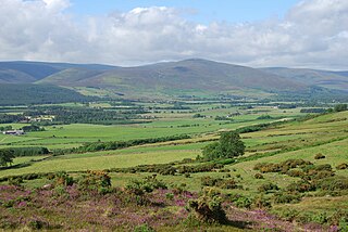
Glen Lui from Gleann Laoigh – calves' glen – Gordon (1925) is one of the major glens on the Mar Lodge Estate, in Aberdeenshire, Scotland.

Victoria Bridge is the early 20th century lattice girder bridge over the River Dee at Mar Lodge on Mar Lodge Estate, Aberdeenshire, Scotland. This bridge, built in 1905 and replaced an earlier wooden bridge, built in 1848 by the Duke of Leeds during his tenancy of the estate. The archway at the south end of the bridge bears '1848 Queen Victoria 1848' on the south side and '1905 Edward VII 1905' commemorating the construction of both bridges and the reigning monarch at the time.
Corriemulzie is a locality on Mar Lodge Estate, Aberdeenshire, Scotland.
Mar Lodge Estate is the largest remnant of the ancient Earldom of Mar in Aberdeenshire, Scotland and is now owned by the National Trust for Scotland.

Beinn a' Bhùird is a Munro in the Cairngorm mountain range of Scotland.
The Cairngorm Club is a mountaineering club, based in Aberdeen, Scotland formed in June 1887.
The Muckle Spate was a great flood in August 1829, which devastated much of Strathspey, in the north east of Scotland.

Bloak was a hamlet or clachan in East Ayrshire, Parish of Stewarton, Scotland. The habitation was situated between Auchentiber and Stewarton on the B778. It was originally built as a row of housing for crofters and farm workers. The small school remained open for some years after the hamlet ceased to exist. Robinson gives the Scots word "blout" as meaning "an eruption of fluid", or a place that is soft or wet.

Abercynllaith, also sometimes referred to as Aberkenllith, is a hamlet, between Llangedwyn and Pen-y-bont in northeastern Powys, Wales. It lies to the southwest of Oswestry, Shropshire, along the B4396 road, near the English border.

The Lairig an Laoigh is a mountain pass through the Highlands of Scotland. In speech and sometimes in writing the name is reduced to "Lairig Laoigh". It is of glacial origin, dissecting the Cairngorm plateau, and it runs roughly north–south from Speyside to Deeside at one time being used as a drove road. Between the public road in the Abernethy Forest and the one at Linn of Dee the trekking distance is 31 kilometres (19 mi).


 Allanaquoich from the Linn of Dee road (September 2006)
 Quoich Cottage from the Linn of Dee road (21AUG07)
 General view of Allanaquoich from the Linn of Dee road (07MAR04)

