External links
- Anticyclonic Rotation - AMS Glossary of Meteorology
Anticyclonic rotation, or anticyclonic circulation, is atmospheric motion in the direction opposite to a cyclonic rotation. For cyclonic rotation, this motion is in a counter-clockwise direction in the Northern Hemisphere and clockwise in the Southern Hemisphere. Thus, just anticyclonic rotation would mean clockwise in the Northern Hemisphere and counter-clockwise in the Southern. For large-scale weather systems, greater than approximately 500 km (310 mi), anticyclonic rotation only occurs for high-pressure systems. This is due to how the Coriolis effect acts on high-pressure systems. Large, low-pressure systems, such as tropical cyclones, have cyclonic rotation. Small scale rotating atmospheric features, such as tornadoes, water spouts, and dust devils can have either anticyclonic or cyclonic rotation, since the direction of their spin depends on local forces rather than the Coriolis effect.

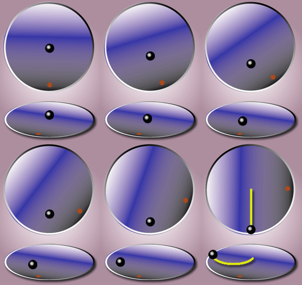
In physics, the Coriolis force is an inertial or fictitious force that acts on objects in motion within a frame of reference that rotates with respect to an inertial frame. In a reference frame with clockwise rotation, the force acts to the left of the motion of the object. In one with anticlockwise rotation, the force acts to the right. Deflection of an object due to the Coriolis force is called the Coriolis effect. Though recognized previously by others, the mathematical expression for the Coriolis force appeared in an 1835 paper by French scientist Gaspard-Gustave de Coriolis, in connection with the theory of water wheels. Early in the 20th century, the term Coriolis force began to be used in connection with meteorology.

In meteorology, a cyclone is a large air mass that rotates around a strong center of low atmospheric pressure, counterclockwise in the Northern Hemisphere and clockwise in the Southern Hemisphere as viewed from above. Cyclones are characterized by inward-spiraling winds that rotate about a zone of low pressure. The largest low-pressure systems are polar vortices and extratropical cyclones of the largest scale. Warm-core cyclones such as tropical cyclones and subtropical cyclones also lie within the synoptic scale. Mesocyclones, tornadoes, and dust devils lie within the smaller mesoscale. Upper level cyclones can exist without the presence of a surface low, and can pinch off from the base of the tropical upper tropospheric trough during the summer months in the Northern Hemisphere. Cyclones have also been seen on extraterrestrial planets, such as Mars, Jupiter, and Neptune. Cyclogenesis is the process of cyclone formation and intensification. Extratropical cyclones begin as waves in large regions of enhanced mid-latitude temperature contrasts called baroclinic zones. These zones contract and form weather fronts as the cyclonic circulation closes and intensifies. Later in their life cycle, extratropical cyclones occlude as cold air masses undercut the warmer air and become cold core systems. A cyclone's track is guided over the course of its 2 to 6 day life cycle by the steering flow of the subtropical jet stream.

An anticyclone is a weather phenomenon defined as a large-scale circulation of winds around a central region of high atmospheric pressure, clockwise in the Northern Hemisphere and counterclockwise in the Southern Hemisphere as viewed from above. Effects of surface-based anticyclones include clearing skies as well as cooler, drier air. Fog can also form overnight within a region of higher pressure.

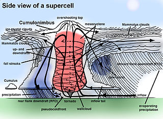
A mesocyclone is a meso-gamma mesoscale region of rotation (vortex), typically around 2 to 6 mi in diameter, most often noticed on radar within thunderstorms. In the northern hemisphere it is usually located in the right rear flank of a supercell, or often on the eastern, or leading, flank of a high-precipitation variety of supercell. The area overlaid by a mesocyclone’s circulation may be several miles (km) wide, but substantially larger than any tornado that may develop within it, and it is within mesocyclones that intense tornadoes form.

Physical oceanography is the study of physical conditions and physical processes within the ocean, especially the motions and physical properties of ocean waters.

A high-pressure area, high, or anticyclone, is an area near the surface of a planet where the atmospheric pressure is greater than the pressure in the surrounding regions. Highs are middle-scale meteorological features that result from interplays between the relatively larger-scale dynamics of an entire planet's atmospheric circulation.

In meteorology, a low-pressure area, low area or low is a region where the atmospheric pressure is lower than that of surrounding locations. Low-pressure areas are commonly associated with inclement weather, while high-pressure areas are associated with lighter winds and clear skies. Winds circle anti-clockwise around lows in the northern hemisphere, and clockwise in the southern hemisphere, due to opposing Coriolis forces. Low-pressure systems form under areas of wind divergence that occur in the upper levels of the atmosphere (aloft). The formation process of a low-pressure area is known as cyclogenesis. In meteorology, atmospheric divergence aloft occurs in two kinds of places:
In atmospheric science, geostrophic flow is the theoretical wind that would result from an exact balance between the Coriolis force and the pressure gradient force. This condition is called geostrophic equilibrium or geostrophic balance. The geostrophic wind is directed parallel to isobars. This balance seldom holds exactly in nature. The true wind almost always differs from the geostrophic wind due to other forces such as friction from the ground. Thus, the actual wind would equal the geostrophic wind only if there were no friction and the isobars were perfectly straight. Despite this, much of the atmosphere outside the tropics is close to geostrophic flow much of the time and it is a valuable first approximation. Geostrophic flow in air or water is a zero-frequency inertial wave.

In oceanography, a gyre is any large system of circulating ocean currents, particularly those involved with large wind movements. Gyres are caused by the Coriolis effect; planetary vorticity, horizontal friction and vertical friction determine the circulatory patterns from the wind stress curl (torque).

The westerlies, anti-trades, or prevailing westerlies, are prevailing winds from the west toward the east in the middle latitudes between 30 and 60 degrees latitude. They originate from the high-pressure areas in the horse latitudes and trend towards the poles and steer extratropical cyclones in this general manner. Tropical cyclones which cross the subtropical ridge axis into the westerlies recurve due to the increased westerly flow. The winds are predominantly from the southwest in the Northern Hemisphere and from the northwest in the Southern Hemisphere.

An anticyclonic storm is a storm with a high-pressure center, in which winds flow in the direction opposite to that of the flow above a region of low pressure. These storms can create powerful mesoanticylonic supercell storms that can generate anticyclonic tornadoes. Examples include the anticyclonic blizzard of 2018, Hartmut, and Neptune's anticyclonic cloud system.

An atmospheric wave is a periodic disturbance in the fields of atmospheric variables which may either propagate or not. Atmospheric waves range in spatial and temporal scale from large-scale planetary waves to minute sound waves. Atmospheric waves with periods which are harmonics of 1 solar day are known as atmospheric tides.

The Fujiwhara effect, sometimes referred to as the Fujiwara effect, Fujiw(h)ara interaction or binary interaction, is a phenomenon that occurs when two nearby cyclonic vortices move around each other and close the distance between the circulations of their corresponding low-pressure areas. The effect is named after Sakuhei Fujiwhara, the Japanese meteorologist who initially described the effect. Binary interaction of smaller circulations can cause the development of a larger cyclone, or cause two cyclones to merge into one. Extratropical cyclones typically engage in binary interaction when within 2,000 kilometres (1,200 mi) of one another, while tropical cyclones typically interact within 1,400 kilometres (870 mi) of each other.

An anticyclonic tornado is a tornado which rotates in a clockwise direction in the Northern Hemisphere and a counterclockwise direction in the Southern Hemisphere. The term is a naming convention denoting the anomaly from normal rotation which is cyclonic in upwards of 98 percent of tornadoes. Many anticyclonic tornadoes are smaller and weaker than cyclonic tornadoes, forming from a different process, as either companion/satellite tornadoes or nonmesocyclonic tornadoes.

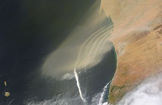
Berg wind is the South African name for a katabatic wind: a hot dry wind blowing down the Great Escarpment from the high central plateau to the coast.
Cyclonic rotation, or cyclonic circulation, is atmospheric motion in the same direction as a planet's rotation, as opposed to anticyclonic rotation. For Earth, the Coriolis effect causes cyclonic rotation to be in a counterclockwise direction in the Northern Hemisphere and clockwise in the Southern Hemisphere. A closed area of winds rotating cyclonically is known as a cyclone.
In atmospheric science, balanced flow is an idealisation of atmospheric motion. The idealisation consists in considering the behaviour of one isolated parcel of air having constant density, its motion on a horizontal plane subject to selected forces acting on it and, finally, steady-state conditions.

Tropical cyclone track forecasting involves predicting where a tropical cyclone is going to track over the next five days, every 6 to 12 hours. The history of tropical cyclone track forecasting has evolved from a single-station approach to a comprehensive approach which uses a variety of meteorological tools and methods to make predictions. The weather of a particular location can show signs of the approaching tropical cyclone, such as increasing swell, increasing cloudiness, falling barometric pressure, increasing tides, squalls and heavy rainfall.

The Beaufort Gyre is one of the two major ocean currents in the Arctic Ocean. It is roughly located north of the Alaskan and Canadian coast. In the past, Arctic sea-ice would circulate in the Beaufort gyre up to several years, leading to the formation of very thick multi-year sea-ice. Due to warming temperatures in the Arctic, the gyre has lost an extensive amount of ice, practically turning what used to be a nursery for sea-ice to mature and grow into the thickest and oldest ice of the Arctic Ocean into a "graveyard" for older ice.
A Wind generated current is a flow in a body of water that is generated by wind friction on its surface. Wind can generate surface currents on water bodies of any size. The depth and strength of the current depend on the wind strength and duration, and on friction and viscosity losses, but are limited to about 400 m depth by the mechanism, and to lesser depths where the water is shallower. The direction of flow is influenced by the Coriolis effect, and is offset to the right of the wind direction in the Northern Hemisphere, and to the left in the Southern Hemisphere. A wind current can induce secondary water flow in the form of upwelling and downwelling, geostrophic flow, and western boundary currents.