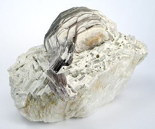
Lepidolite is a lilac-gray or rose-colored member of the mica group of minerals with chemical formula K(Li,Al)3(Al,Si,Rb)4O10(F,OH)2. It is the most abundant lithium-bearing mineral and is a secondary source of this metal. It is the major source of the alkali metal rubidium.
Lynn Lake is a town in the northwest region of Manitoba, Canada, approximately 1,071 km (665 mi) from Winnipeg. The town is the fourth-largest town in Manitoba in terms of land area. It is centred on the original urban community of Lynn Lake. The town was named after Lynn Smith, chief engineer of Sherritt Gordon Mines Ltd. There are many outfitters in the Lynn Lake area, offering services for most wilderness experiences, including sport fishing and bear and moose hunting.

Northern Manitoba is a geographic and cultural region of the Canadian province of Manitoba. Originally encompassing a small square around the Red River Colony, the province was extended north to the 60th parallel in 1912. The region's specific boundaries vary, as "northern" communities are considered to share certain social and geographic characteristics, regardless of latitude.

Whiteshell Provincial Park is a provincial park in southeast Manitoba, approximately 120 kilometres (75 mi) east of the city of Winnipeg. The park is considered to be a Class II protected area under the IUCN protected area management categories. It is 275,210 hectares in size.
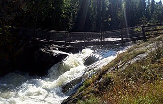
The Whiteshell River is one of the major rivers in Whiteshell Provincial Park, in southeastern Manitoba, Canada, near the Ontario border. This river is close to some petroform sites that are about 2000 years old or older. The name "whiteshell" is in reference to the Meegis or cowry shells used by Ojibwa peoples in their ceremonies and teachings, especially the Midewiwin, and as recorded in their birch bark scrolls.

Nopiming Provincial Park is a natural provincial park in Manitoba, Canada, located on the southeast side of the province, along the boundary with Ontario.
Atikaki Provincial Park is a wilderness park in Manitoba, Canada, located east of Lake Winnipeg along the Ontario boundary in the Canadian Shield. The area of Atikaki Provincial Park is 3,981 square kilometres (1,537 sq mi). Atikaki Provincial Park is north of Nopiming Provincial Park and borders the Woodland Caribou Provincial Park in Ontario.
Treaty 2 was entered in to on 21 August 1872 at Manitoba House, Rupertsland, with representatives of the Queen of Great Britain and Ireland. The original Anishinaabe, who were present, constitute Treaty 2 today. It is known that many of the chiefs and leaders within the territory were at the early gathering and after the treaty was agreed to. Those who were not present were represented through Metis until they indicated where they wished their farming reserves to be established. The treaty reaffirmed the inherent rights that the Anishinaabe had prior to European contact, located where southwestern Manitoba is today and a small part of southeastern Saskatchewan.

Highway 5 is a major highway in the Canadian province of Saskatchewan. It begins in downtown Saskatoon and runs eastward to the Manitoba border near Togo, where it becomes Provincial Road 363. The highway is approximately 393 kilometres (244 mi) long. Between the early 1900s (decade) and 1976, Provincial Highway 5 was a trans-provincial highway travelling approximately 630 kilometres (390 mi) in length. At this time it started at the Alberta border in Lloydminster and traveled east to the Manitoba border.
Petr Černý FRSC was a mineralogy professor at the University of Manitoba.
Wekusko Falls Provincial Park is a provincial park straddling the Grass River and Wekusko Lake, located in central Manitoba on Manitoba Provincial Road 392 near Snow Lake, Manitoba.
Booster Lake is located in Nopiming Provincial Park in the province of Manitoba, Canada.
The Bird River greenstone belt is an Archean greenstone belt in southeastern Manitoba, Canada.
Grass River Provincial Park is a 2,279 km2 provincial park in Northwestern Manitoba, Canada. Designated in 1963, the park is approximately 75 km north of The Pas and is centered on the Grass River. The southern part of the park includes portions of the dolomitic Manitoba Lowlands portion of the Interior Plains, while the northern portion includes part of the granitic Canadian Shield. It it crossed east-west by Manitoba Highway 39, with PTH 10 crossing the western edge of the park. The entire park shows evidence of glaciation. The park is considered to be a Class III protected area under the IUCN protected area management categories.
The Porcupine Hills refer to various groups of hills and uplands located in the prairie provinces of Canada, specifically the provinces of Saskatchewan and Manitoba. They are part of the Manitoba Escarpment, which was the shoreline of the ancient glacial Lake Agassiz. The hills are located north-west of Swan River, Manitoba, and are the headwaters of the Swan River. The highest elevation in the Porcupine Hills is Hart Mountain, at an elevation of 823 metres (2,700 ft), which makes it Manitoba's second-highest point. The Porcupine Provincial Forest surrounds the area.

Tanco Mine or Bernic Lake mine is an underground caesium and tantalum mine, owned and since 2019 owned and operated by Sinomine Resource Group on the north west shore of Bernic Lake, Manitoba, Canada. The mine has the largest known deposit of pollucite and is also the world's largest producer of caesium.
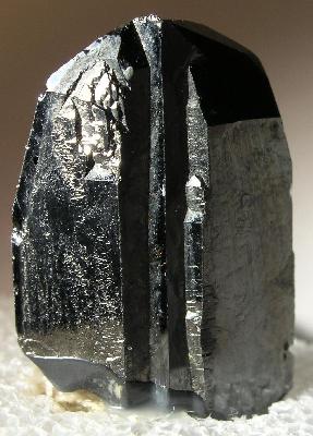
Wodginite is a manganese, tin, tantalum oxide mineral with the chemical formula Mn2+(Sn,Ta)Ta2O8. It may also include significant amounts of niobium.
Sasagiu Rapids Provincial Park is a provincial park in Manitoba, Canada. It is located 85 kilometres south of Thompson on Highway 6, and covers all portions of unsubdivided Sections 10 and 15 Township 71 Range 7 W.P.M. shown on Plan 19853. It lies in the southwestern portion of the Mystery Lake Local Government District.

Ixiolite is an accessory oxide mineral found in granitic pegmatites. It is an oxide with the general chemical formula (Ta,Nb,Sn,Mn,Fe)4O8 or (Ta,Mn,Nb)O2.
Zed Lake Provincial Park is a provincial park in Manitoba, Canada, established in 1961. It is 12.07 ha in size. The park is located on the east shore of the eponymous lake, about 27 kilometres (17 mi) north of Lynn Lake on PR 394. The park has 25 cottage lots, a campground, a boat launch and a beach.

