Centla Municipality

Last updated
Centla
Municipality
Centla en Tabasco.svg
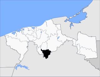
Location of the municipality in Tabasco.
CountryFlag of Mexico.svg  Mexico
State Tabasco
Time zone Central Standard Time (UTC-6)
  Summer (DST) Central Daylight Time (UTC-5)

Centla is a municipality in Tabasco in south-eastern Mexico. [1]

Municipalities of Tabasco Wikimedia list article

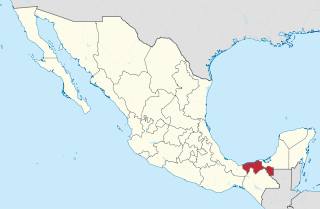
Tabasco is a state in Southeast Mexico that is divided into 17 municipalities.

Tabasco State of Mexico

Tabasco, officially the Free and Sovereign State of Tabasco, is one of the 32 Federal Entities of Mexico. It is divided into 17 municipalities and its capital city is Villahermosa. It is located in the southeast of the country bordering the states of Campeche to the northeast, Veracruz to the west and Chiapas to the south, and the Petén department of Guatemala to the southeast. It has a coastline to the north with the Gulf of Mexico. Most of the state is covered in rainforest as, unlike most other areas of Mexico, it has plentiful rainfall year round. For this reason, it is also covered in small lakes, wetlands and rivers. The state is subject to major flooding events, with the last occurring in 2007, which affected eighty percent of the state. The state is also home to La Venta, the major site of the Olmec civilization, considered to be the origin of later Mesoamerican cultures. Even though it produces significant quantities of petroleum and natural gas, poverty is still a concern.

Mexico country in the southern portion of North America

Mexico, officially the United Mexican States, is a country in the southern portion of North America. It is bordered to the north by the United States; to the south and west by the Pacific Ocean; to the southeast by Guatemala, Belize, and the Caribbean Sea; and to the east by the Gulf of Mexico. Covering almost 2,000,000 square kilometres (770,000 sq mi), the nation is the fifth largest country in the Americas by total area and the 13th largest independent state in the world. With an estimated population of over 120 million people, the country is the eleventh most populous state and the most populous Spanish-speaking state in the world, while being the second most populous nation in Latin America after Brazil. Mexico is a federation comprising 31 states and Mexico City, a special federal entity that is also the capital city and its most populous city. Other metropolises in the state include Guadalajara, Monterrey, Puebla, Toluca, Tijuana and León.

Related Research Articles

Alta Verapaz Department Departments of Guatemala

Alta Verapaz is a department in the north central part of Guatemala. The capital and chief city of the department is Cobán. Verapaz is bordered to the north by El Petén, to the east by Izabal, to the south by Zacapa, El Progreso, and Baja Verapaz, and to the west by El Quiché.

Benito Juárez Municipality, Guerrero Municipality in Guerrero, Mexico

Benito Juárez is one of the 81 municipalities of Guerrero, in south-western Mexico. The municipal seat lies at San Jerónimo de Juárez. The municipality covers an area of 284.9 km².

El Porvenir, Chiapas Municipality in Chiapas, Mexico

El Porvenir is a municipio (municipality) and township in the Mexican state of Chiapas.

Ocosingo Municipality in Chiapas, Mexico

Ocosingo is a city and its surrounding municipality (municipio) of the same name in the Mexican state of Chiapas.

Viana is a town and municipality located in the province and autonomous community of Navarre, northern Spain. Cesare Borgia is buried there.

Pantanos de Centla

The Pantanos de Centla is a tropical moist forest ecoregion in southern Mexico, which includes seasonally flooded forests and wetlands, in the summer.

San Miguel Yotao Municipality and town in Oaxaca, Mexico

San Miguel Yotao is a town and municipality in Oaxaca in south-western Mexico. The municipality covers an area of 58.69 km². It is part of the Ixtlán District in the Sierra Norte region.

Santiago Nundiche is a town and municipality in Oaxaca in south-western Mexico. The municipality covers an area of km². It is part of the Tlaxiaco District in the south of the Mixteca Region.

San Antonio Cañada (municipality) is a town and municipality in Puebla in south-eastern Mexico.

San Matías Tlalancaleca is a town and municipality in Puebla in south-eastern Mexico.

Xiutetelco Municipality is a municipality in Puebla in south-eastern Mexico.

Zoquitlán (municipality) is a town and municipality in Puebla in south-eastern Mexico.

Huatabampo Municipality is a municipality in Sonora in north-western Mexico. As of 2015, the municipality had a total population of 80,524.

Jalapa Municipality Municipality in Tabasco, Mexico

Jalapa Municipality is a municipality in Tabasco in south-eastern Mexico.

Jonuta Municipality Municipality in Tabasco, Mexico

Jonuta Municipality is a municipality in Tabasco in south-eastern Mexico.

Tacotalpa Municipality Municipality in Tabasco, Mexico

Tacotalpa is a municipality in Tabasco in south-eastern Mexico.

Teapa Municipality Municipality in Tabasco, Mexico

Teapa Municipality is a municipality in Tabasco in south-eastern Mexico. Its name comes from the Nahuatl words "Tetl and apan", which mean "river over stones" or "stone's river". It refers to one of the rivers that crosses the town.

Matlapa is a town and municipality in San Luis Potosí in central Mexico.

Palacio de la Autonomía

The Palacio de la Autonomía is a museum and site where the Universidad Nacional Autónoma de México gained autonomy from direct government control in 1929. The building is from the late 19th century, and located on the corner of Licenciado de Verdad and Rep de Guatemala streets, north of Santa Teresa la Antigua and east of Templo Mayor. The site has a 500-year history, starting from part of lands granted by Hernán Cortés. The current building was constructed by the administration of President Porfirio Díaz, but it was ceded to the University in 1910. Since that time, the building has had a number of uses, including housing a dental school and a preparatory school. Today it houses the Museo de la Autonomía Universitaria.

Cebolla Wilderness

Cebolla Wilderness is a 61,600-acre (24,900 ha) Wilderness area located within the El Malpais National Conservation Area in New Mexico. The area was added to the National Wilderness Preservation System on December 31, 1987 by Public Law 100-225. The area is a bordered by the Acoma Pueblo to the east and the El Malpais National Monument and New Mexico Highway 117 to the west. Elevations range from 7,000 feet (2,100 m) to 8,200 feet (2,500 m). The sandstone canyons and mesas of this rimrock area include features such as La Ventana natural arch.

References

  1. "-". Enciclopedia de los Municipios de México. Instituto Nacional para el Federalismo y el Desarrollo Municipal . Retrieved January 4, 2010.

Coordinates: 18°20′N92°30′W / 18.333°N 92.500°W / 18.333; -92.500

Geographic coordinate system Coordinate system

A geographic coordinate system is a coordinate system that enables every location on Earth to be specified by a set of numbers, letters or symbols. The coordinates are often chosen such that one of the numbers represents a vertical position and two or three of the numbers represent a horizontal position; alternatively, a geographic position may be expressed in a combined three-dimensional Cartesian vector. A common choice of coordinates is latitude, longitude and elevation. To specify a location on a plane requires a map projection.