
A compass is a device that shows the cardinal directions used for navigation and geographic orientation. It commonly consists of a magnetized needle or other element, such as a compass card or compass rose, which can pivot to align itself with magnetic north. Other methods may be used, including gyroscopes, magnetometers, and GPS receivers.

Flight instruments are the instruments in the cockpit of an aircraft that provide the pilot with data about the flight situation of that aircraft, such as altitude, airspeed, vertical speed, heading and much more other crucial information in flight. They improve safety by allowing the pilot to fly the aircraft in level flight, and make turns, without a reference outside the aircraft such as the horizon. Visual flight rules (VFR) require an airspeed indicator, an altimeter, and a compass or other suitable magnetic direction indicator. Instrument flight rules (IFR) additionally require a gyroscopic pitch-bank, direction and rate of turn indicator, plus a slip-skid indicator, adjustable altimeter, and a clock. Flight into instrument meteorological conditions (IMC) require radio navigation instruments for precise takeoffs and landings.

In navigation, dead reckoning is the process of calculating the current position of a moving object by using a previously determined position, or fix, and incorporating estimates of speed, heading, and elapsed time. The corresponding term in biology, to describe the processes by which animals update their estimates of position or heading, is path integration.

In navigation, bearing or azimuth is the horizontal angle between the direction of an object and north or another object. The angle value can be specified in various angular units, such as degrees, mils, or grad. More specifically:
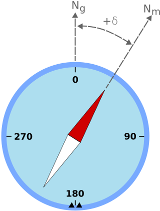
Magnetic declination is the angle between magnetic north and true north at a particular location on the Earth's surface. The angle can change over time due to polar wandering.
The basic principles of air navigation are identical to general navigation, which includes the process of planning, recording, and controlling the movement of a craft from one place to another.

A non-directional beacon (NDB) or non-directional radio beacon is a radio beacon which does not include inherent directional information. Radio beacons are radio transmitters at a known location, used as an aviation or marine navigational aid. NDB are in contrast to directional radio beacons and other navigational aids, such as low-frequency radio range, VHF omnidirectional range (VOR) and tactical air navigation system (TACAN).

The BeiDou Navigation Satellite System is a satellite-based radio navigation system owned and operated by the China National Space Administration. It is one of the global navigation satellite systems (GNSS) that provide geolocation and time information to a BDS receiver anywhere on or near the Earth where there is an unobstructed line of sight to four or more BDS satellites. It does not require the user to transmit any data, and operates independently of any telephonic or Internet reception, though these technologies can enhance the usefulness of the BDS positioning information.

Geomatics is defined in the ISO/TC 211 series of standards as the "discipline concerned with the collection, distribution, storage, analysis, processing, presentation of geographic data or geographic information". Under another definition, it consists of products, services and tools involved in the collection, integration and management of geographic (geospatial) data. Surveying engineering was the widely used name for geomatic(s) engineering in the past. Geomatics was placed by the UNESCO Encyclopedia of Life Support Systems under the branch of technical geography.

An automotive navigation system is part of the automobile controls or a third party add-on used to find direction in an automobile. It typically uses a satellite navigation device to get its position data which is then correlated to a position on a road. When directions are needed routing can be calculated. On the fly traffic information can be used to adjust the route.

A satellite navigation or satnav system is a system that uses satellites to provide autonomous geopositioning. A satellite navigation system with global coverage is termed global navigation satellite system (GNSS). As of 2023, four global systems are operational: the United States's Global Positioning System (GPS), Russia's Global Navigation Satellite System (GLONASS), China's BeiDou Navigation Satellite System (BDS), and the European Space Agency's Galileo.
Magnetic deviation is the error induced in a compass by local magnetic fields, which must be allowed for, along with magnetic declination, if accurate bearings are to be calculated.

An astrocompass is a navigational tool for determining the direction of true north through the positions of various astronomical bodies. It is an evolution of earlier solar compass designs.
West is a cardinal direction or compass point.

Diver navigation, termed "underwater navigation" by scuba divers, is a set of techniques—including observing natural features, the use of a compass, and surface observations—that divers use to navigate underwater. Free-divers do not spend enough time underwater for navigation to be important, and surface supplied divers are limited in the distance they can travel by the length of their umbilicals and are usually directed from the surface control point. On those occasions when they need to navigate they can use the same methods used by scuba divers.
Augmentation of a global navigation satellite system (GNSS) is a method of improving the navigation system's attributes, such as precision, reliability, and availability, through the integration of external information into the calculation process. There are many such systems in place, and they are generally named or described based on how the GNSS sensor receives the external information. Some systems transmit additional information about sources of error, others provide direct measurements of how much the signal was off in the past, while a third group provides additional vehicle information to be integrated in the calculation process.
Global Navigation Satellite System (GNSS) receivers, using the GPS, GLONASS, Galileo or BeiDou system, are used in many applications. The first systems were developed in the 20th century, mainly to help military personnel find their way, but location awareness soon found many civilian applications.

GPS Block IIF, or GPS IIF is an interim class of GPS (satellite) which were used to bridge the gap between previous Navstar Global Positioning System generations until the GPS Block III satellites became operational. They were built by Boeing, operated by the United States Air Force, and launched by the United Launch Alliance (ULA) using Evolved Expendable Launch Vehicles (EELV). They are the final component of the Block II GPS constellation to be launched. On 5 February 2016, the final Block IIF satellite was successfully launched, completing the series.

The compass is a magnetometer used for navigation and orientation that shows direction in regards to the geographic cardinal points. The structure of a compass consists of the compass rose, which displays the four main directions on it: East (E), South (S), West (W) and North (N). The angle increases in the clockwise position. North corresponds to 0°, so east is 90°, south is 180° and west is 270°.
Beidou-3 M1 is one of a pair of two Chinese navigation satellites launched in November 2017 as part of the BeiDou satellite navigation system. It was launched with BeiDou-3 M2.