The Union of Utrecht was a treaty signed on 23 January 1579 in Utrecht, Netherlands, unifying the northern provinces of the Netherlands, until then under the control of Habsburg Spain.

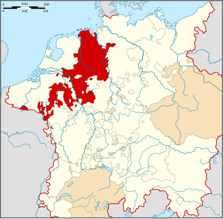
Gelderland, also known as Guelders in English, is a province of the Netherlands, occupying the centre-east of the country. With a total area of 5,136 km2 (1,983 sq mi) of which 173 km2 (67 sq mi) is water, it is the largest province of the Netherlands by land area, and second by total area. Gelderland shares borders with six other provinces and the German state of North Rhine-Westphalia.

The Duchy of Guelders is a historical duchy, previously county, of the Holy Roman Empire, located in the Low Countries.

The Seventeen Provinces were the Imperial states of the Habsburg Netherlands in the 16th century. They roughly covered the Low Countries, i.e., what is now the Netherlands, Belgium, Luxembourg, and most of the French departments of Nord and Pas-de-Calais (Artois). Also within this area were semi-independent fiefdoms, mainly ecclesiastical ones, such as Liège, Cambrai and Stavelot-Malmedy.

The Achterhoek is a cultural region in the Eastern Netherlands. Its name is geographically appropriate because the area lies in the easternmost part of the province of Gelderland and therefore in the east of the Netherlands, protruding into Germany. The Achterhoek lies at the east of the IJssel and Oude IJssel rivers. On the other sides, it borders Germany to the southeast and the province of Overijssel to the northeast.

The House of Egmond or Egmont is named after the Dutch town of Egmond, province of North Holland, and played an important role in the Netherlands during the Middle Ages and the Early modern period. The main lines Egmond-Geldern, Egmond-Gavere and Egmond-Buren-Leerdam had high noble, princely rank.

The Duchy of Cleves was a State of the Holy Roman Empire which emerged from the medieval Hettergau. It was situated in the northern Rhineland on both sides of the Lower Rhine, around its capital Cleves and the towns of Wesel, Kalkar, Xanten, Emmerich, Rees and Duisburg bordering the lands of the Prince-Bishopric of Münster in the east and the Duchy of Brabant in the west. Its history is closely related to that of its southern neighbours: the Duchies of Jülich and Berg, as well as Guelders and the Westphalian county of Mark. The Duchy was archaically known as Cleveland in English.

Goch is a town in the district of Kleve, in North Rhine-Westphalia, Germany. It is situated close to the border with the Siebengewald in Netherlands, approx. 12 km (7 mi) south of Kleve, and 27 km (17 mi) southeast of Nijmegen.

The Burgundian Circle was an Imperial Circle of the Holy Roman Empire created in 1512 and significantly enlarged in 1548. In addition to the Free County of Burgundy, the Burgundian Circle roughly covered the Low Countries, i.e., the areas now known as the Netherlands, Belgium and Luxembourg and adjacent parts in the French administrative region of Nord-Pas-de-Calais. For most of its history, its lands were coterminous with the holdings of the Spanish Habsburgs in the Empire.
The Lower Rhenish–Westphalian Circle was an Imperial Circle of the Holy Roman Empire. It comprised territories of the former Duchy of Lower Lotharingia, Frisia and the Westphalian part of the former Duchy of Saxony.

Geldern is a city in the federal German state of North Rhine-Westphalia. It is part of the district of Kleve, which is part of the Düsseldorf administrative region. The Dutch province of Gelderland is named after this city.

William of Jülich-Cleves-Berge was a Duke of Jülich-Cleves-Berg (1539–1592). William was born in and died in Düsseldorf. He was the only son of John III, Duke of Jülich-Cleves-Berg, and Maria, Duchess of Jülich-Berg. William took over rule of his father's estates upon his death in 1539. Despite his mother having lived until 1543, William also became the Duke of Berg and Jülich and the Count of Ravensberg.
The title of Count of Zutphen historically belonged to the ruler of the Dutch province of Gelderland. The lordship was a vassal title before it eventually became a county itself.
The Treaty of Venlo of 7 September 1543 concluded the Guelders Wars (1502–1543), and the definitive acquisition of the Duchy of Guelders and the adjoining County of Zutphen by the House of Habsburg, adding them to the Habsburg Netherlands. William V, Duke of the United Duchies of Jülich-Cleves-Berg had to relinquish his claims to Guelders and Zutphen in favour of the Holy Roman Emperor and King of Spain, Charles V of Habsburg.

Gerard III of Guelders was the Count of Guelders and Zutphen from 1207 until his death in 1229. He was a son of Count Otto I of Guelders, and is sometimes called Gerard IV or Gerard V. Gerard married Margaretha of Brabant, the daughter of Duke Hendrik I of Brabant and Matilda of Flanders, Duchess of Brabant, in 1206.
Reginald II of Guelders, called "the Black", was Count of Guelders, and from 1339 onwards Duke of Guelders, and Zutphen, in the Low Countries, from 1326 to 1343. He was the son of Reginald I of Guelders and Marguerite of Flanders.

William was Duke of Guelders, as William I, from 1377 and Duke of Jülich, as William III, from 1393. William was known for his military activities, participating in the Prussian crusade five times and battling with neighbors in France and Brabant throughout his rule. His allies included Holy Roman Emperors, Charles IV and Wenceslaus, Richard II of England, and Conrad Zöllner von Rothenstein, the Grand Master of the Teutonic Knights. During his reign the duchies of Guelders and Jülich were temporarily unified.

Adolf of Egmond was a Duke of Guelders, Count of Zutphen from 1465 to 1471 and in 1477.

Upper Guelders or Spanish Guelders was one of the four quarters in the Imperial Duchy of Guelders. In the Dutch Revolt, it was the only quarter that did not secede from the Habsburg monarchy to become part of the Seven United Netherlands, but remained under Spanish rule during the Eighty Years' War.

The Nijmegen Quarter was the first of the four quarters in which the county, later duchy of Guelders was divided, as they were separated by rivers. In addition Guelders consisted of Zutphen Quarter, the Upper Quarter and Veluwe Quarter. Each quarter had its own capital.

