Related Research Articles

Lake Ladoga is a freshwater lake located in the Republic of Karelia and Leningrad Oblast in northwestern Russia, in the vicinity of Saint Petersburg.
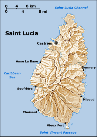
Saint Lucia is one of many small land masses composing the insular group known as the Windward Islands. Unlike large limestone areas such as Florida, Cuba, and the Yucatan Peninsula, or the Bahamas, which is a small island group composed of coral and sand, Saint Lucia is a typical Windward Island formation of volcanic rock that came into existence long after much of the region had already been formed.

Hudson Strait in Nunavut links the Atlantic Ocean and the Labrador Sea to Hudson Bay in Canada. This strait lies between Baffin Island and Nunavik, with its eastern entrance marked by Cape Chidley in Newfoundland and Labrador and Nunavut and Resolution Island, off Baffin Island. The strait is about 750 km (470 mi) long with an average width of 125 km (78 mi), varying from 70 km (43 mi) at the eastern entrance to 240 km (150 mi) at Deception Bay.

The Gulf of St. Lawrence fringes the shores of the provinces of Quebec, New Brunswick, Nova Scotia, Prince Edward Island, Newfoundland and Labrador, in Canada, plus the islands Saint-Pierre and Miquelon, possessions of France, in North America.

The Arctic Archipelago, also known as the Canadian Arctic Archipelago, is an archipelago lying to the north of the Canadian continental mainland, excluding Greenland and Iceland.

Prince William Sound is a sound off the Gulf of Alaska on the south coast of the U.S. state of Alaska. It is located on the east side of the Kenai Peninsula. Its largest port is Valdez, at the southern terminus of the Trans-Alaska Pipeline System. Other settlements on the sound, which contains numerous small islands, include Cordova and Whittier plus the Alaska native villages of Chenega and Tatitlek.

Gros Islet District, one of 10 first order subdivision of the Caribbean island nation of Saint Lucia which includes the island's northernmost point, Cap Point and the notable Cap Estate, where the renowned St. Lucia Golf and Country Club is located. Whilst the town of Gros Islet is an important administrative centre, Rodney Bay is the main financial center of the district.

St. Paul Island is a small uninhabited island located approximately 24 km (15 mi) northeast of Cape North on Cape Breton Island and 71 km (44 mi) southwest of Cape Ray on Newfoundland; it is along the boundary between the Gulf of St. Lawrence and the Cabot Strait.
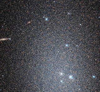
NGC 147 is a dwarf spheroidal galaxy about 2.58 Mly away in the constellation Cassiopeia. NGC 147 is a member of the Local group of galaxies and a satellite galaxy of the Andromeda Galaxy (M31). It forms a physical pair with the nearby galaxy NGC 185, another remote satellite of M31. It was discovered by John Herschel in September 1829. Visually it is both fainter and slightly larger than NGC 185. This means that NGC 147 is more difficult to see than NGC 185, which is visible in small telescopes. In the Webb Society Deep-Sky Observer's Handbook, the visual appearance of NGC 147 is described as follows:
Large, quite faint, irregularly round; it brightens in the middle to a stellar nucleus.

USS David W. Taylor (DD-551) was a Fletcher-class destroyer of the United States Navy, named for Rear Admiral David W. Taylor (1864–1940).

Montague Island (Sugpiaq: Suklluurniilnguq) lies in the Gulf of Alaska at the entrance to Prince William Sound, Alaska. The island has a land area of 790.88 km2, making it the 26th largest island in the United States. As of the 2000 census, Montague did not have a permanent resident population, making it at that time the largest uninhabited island in the United States. Since then, the 2010 abandonment of the United States Coast Guard station on Attu Island in the Aleutian Islands, which at 892.8 km2 is larger than Montague Island, causes Attu to claim that title. Montague Island was named by Captain James Cook in honor of John Montagu, 4th Earl of Sandwich, one of his greatest supporters.
Knight Island is an island in western Prince William Sound of the Gulf of Alaska in the U.S. state of Alaska.
Latouche Island is an island in the southern part of Alaska, United States. It lies in the Gulf of Alaska between Montague Island to the east and Evans Island to the northwest. Latouche Island has a land area of 60.627 km2 and had no resident population at the 2000 census.

ALSIB was the Soviet Union portion of the Alaska-Siberian air road receiving Lend-Lease aircraft from the Northwest Staging Route. Aircraft manufactured in the United States were flown over this route for World War II combat service on the Eastern Front.
German submarine U-279 was a Type VIIC U-boat of Nazi Germany's Kriegsmarine during World War II.

Perry Island is an island in Prince William Sound, Alaska, within the Chugach National Forest, located immediately east of Culross Island. The island was called "Perry" by U.S. Coast and Geodetic Survey in 1900.
Smith Island is an island in the Prince William Sound in Chugach, Alaska, United States. It is located to the east of Eleanor Island, north of Montague Island, and west of Hinchinbrook Island. The island has an maximum elevation of 440 feet (130 m) above the sea level. Its name was first recorded in a land survey in 1900.
References
60°32′52.12″N147°35′6.53″W / 60.5478111°N 147.5851472°W
| | This article about a location in the Chugach Census Area, Alaska is a stub. You can help Wikipedia by expanding it. |