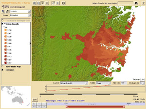
Last updated The dynamic map selection page from the ECAI website.
The Electronic Cultural Atlas Initiative (ECAI) is a digital humanities initiative involving numerous academic professors and institutions around the world with the stated goal of creating a networked digital atlas by creating tools and setting standards for dynamic, digital maps.
ECAI was established in 1997 by Emeritus Prof. Lewis Lancaster of the University of California, Berkeley, and has held two meetings per year most years from 1998 - 2009 (ongoing), one of which is often in conjunction with the Pacific Neighbourhood Consortium. The initiative is based at UC Berkeley.
The ECAI 'clearinghouse' of distributed digital datasets was developed from 1998 by the Archaeological Computing Laboratory at the University of Sydney, and uses the ACL's TimeMap software.
Interlibrary loan is a service whereby a patron of one library can borrow books, DVDs, music, etc. and/or receive photocopies of documents that are owned by another library. The user makes a request with their home library; which, acting as an intermediary, identifies libraries with the desired item, places the request, receives the item, makes it available to the user, as well as arranges for its return. The lending library usually sets a due date and overdue fees of the material borrowed. Although books and journal articles are the most frequently requested items, some libraries will lend audio recordings, video recordings, maps, sheet music, and microforms of all kinds. In some cases, nominal fees accompany the interlibrary loan services.
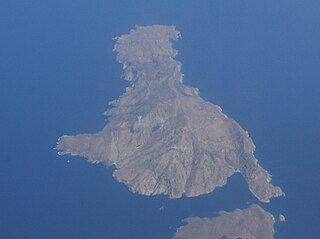
Saria Island, anciently known as Sarus or Saros, is an island in Greece. It is a rocky, volcanic island just to the north of Karpathos, separated from it by a strait 100 m (330 ft) wide. It is part of the Dodekanissos archipelago. In ancient times, a city-state called Saros was situated on the island. It was a member of the Delian League.
The Theban Mapping Project is an archaeological expedition devoted to Ancient Egypt. It was established in 1978 by the Egyptologist Dr. Kent R. Weeks at the University of California, Berkeley. In 1985, it was moved to the American University in Cairo. The Project's original goal was to create an archaeological map of the Valley of the Kings, and that was published as the Atlas of the Valley of the Kings in 2000. Since 2001, the Project has also developed a management plan for the Valley of the Kings, which is funded by the World Monuments Fund.
Michael Keeble Buckland is an emeritus professor at the UC Berkeley School of Information and co-director of the Electronic Cultural Atlas Initiative.
ECAI may refer to:
Pennsylvania Spatial Data Access (PASDA) is Pennsylvania's official public access geospatial information clearinghouse. PASDA serves as Pennsylvania's node on the National Spatial Data Infrastructure (NSDI). PASDA is a cooperative effort of the Pennsylvania Geospatial Technologies Office of the Office of Information Technology and the Pennsylvania State University Institutes of Energy and the Environment (PSIEE).
Three Brothers, three separate mountains of the Mid North Coast region of New South Wales, Australia, are situated approximately 360 kilometres (220 mi) north of Sydney.
The Digital Himalaya project was established in December 2000 by Mark Turin, Alan Macfarlane, Sara Shneiderman, and Sarah Harrison. The project's principal goal is to collect and preserve historical multimedia materials relating to the Himalaya, such as photographs, recordings, and journals, and make those resources available over the internet and offline, on external storage media. The project team have digitized older ethnographic collections and data sets that were deteriorating in their analogue formats, so as to protect them from deterioration and make them available and accessible to originating communities in the Himalayan region and a global community of scholars.
A linguistic map is a thematic map showing the geographic distribution of the speakers of a language, or isoglosses of a dialect continuum of the same language. A collection of such maps is a linguistic atlas.
The European Association for Artificial Intelligence (EurAI) is the representative body for the European artificial intelligence community. The aim of EurAI is to promote the study, research and application of artificial intelligence (AI) in Europe. It was established in 1982.
The Metadata Encoding and Transmission Standard (METS) is a metadata standard for encoding descriptive, administrative, and structural metadata regarding objects within a digital library, expressed using the XML schema language of the World Wide Web Consortium (W3C). The standard is maintained as part of the MARC standards of the Library of Congress, and is being developed as an initiative of the Digital Library Federation (DLF).
A historical geographic information system is a geographic information system that may display, store and analyze data of past geographies and track changes in time. It can be regarded as a tool for historical geography.
Etak, Inc. was an independent US-based vendor of automotive navigation system equipment, digital maps, and mapping software. It was founded in 1983.
TimeMap Java is an open-source web mapping application, which was one of the first such applications to introduce generic time filtering and map animation on the web. TMJava is a comprehensive Java mapping applet which can run as a standalone application with local data, on a web site or as a two tier application with a backend server and independent metadata clearinghouse, supporting distributed data sources.
The Water Resources Collections and Archives (WRCA), formerly known as the Water Resources Center Archives, is an archive with unpublished manuscript collections and a library with published materials. It was established to collect unique, hard-to-find, technical report materials pertaining to all aspects of water resources and supply in California and the American West. Located on the campus of the University of California Riverside (UCR), it is jointly administered by the UCR College of Natural and Agricultural Sciences (CNAS) and the UCR Libraries. WRCA was part of the University of California Center for Water Resources (WRC) that was established and funded in 1957 by a special act of the California State Legislature and was designated the California Water Research Institute by a federal act in 1964.
D-Scribe Digital Publishing is an open access electronic publishing program of the University Library System (ULS) of the University of Pittsburgh. It comprises over 100 thematic collections that together contain over 100,000 digital objects. This content, most of which is available through open access, includes both digitized versions of materials from the collections of the University of Pittsburgh and other local institutions as well as original 'born-electronic' content actively contributed by scholars worldwide. D-Scribe includes such items as photographs, maps, books, journal articles, dissertations, government documents, and technical reports, along with over 745 previously out-of-print titles published by the University of Pittsburgh Press. The digital publishing efforts of the University Library System began in 1998 and have won praise for their innovation from the leadership at the Association of Research Libraries and peer institutions.
The Berkeley River is a river in the Kimberley region of Western Australia.
Count Ludwig August Mellin was a Baltic German politician, cartographer, writer and publicist. He is best known for creating the first professional atlas visualizing Livonia, the Atlas von Liefland, oder von den beyden Gouvernementern u. Herzogthümern Lief- und Ehstland, und der Provinz Oesel in 1798.
Babadıl Islands are two small Mediterranean islands in Turkey. They are named after the former name of the village Sipahili in the mainland facing the islands. According to the British captain Francis Beaufort who was tasked to map the Mediterranean coasts of Turkey in 1811–12, the names of the islands were Papadoulae, in the antiquity. Modern scholarship identifies the island group with Akonesiai, and the northern island with ancient Crambusa or Krambousa (Κράμβουσα).
This page is based on this Wikipedia article Text is available under the CC BY-SA 4.0 license; additional terms may apply. Images, videos and audio are available under their respective licenses.