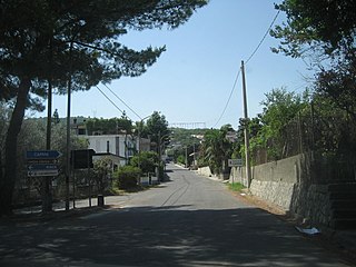
Camini is a comune (municipality) in the Province of Reggio Calabria in the Italian region Calabria, located about 50 kilometres (31 mi) south of Catanzaro and about 80 kilometres (50 mi) northeast of Reggio Calabria.

Campo Calabro is a comune (municipality) in the Province of Reggio Calabria in the Italian region Calabria, located about 110 kilometres (68 mi) southwest of Catanzaro and about 12 kilometres (7 mi) north of Reggio Calabria. As of 31 December 2004, it had a population of 4,193 and an area of 7.5 square kilometres (2.9 sq mi).

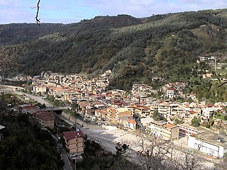
Canolo is a comune (municipality) in the Metropolitan City of Reggio Calabria in the Italian region Calabria, located about 70 kilometres (43 mi) southwest of Catanzaro and about 50 kilometres (31 mi) northeast of Reggio Calabria. As of 31 December 2004, it had a population of 901 and an area of 28.2 square kilometres (10.9 sq mi).
Caraffa del Bianco is a comune (municipality) in the Province of Reggio Calabria in the Italian region Calabria, located about 100 kilometres (62 mi) southwest of Catanzaro and about 35 kilometres (22 mi) east of Reggio Calabria. As of 31 December 2004, it had a population of 605 and an area of 12.3 square kilometres (4.7 sq mi).
Careri is a comune (municipality) in the Province of Reggio Calabria in the Italian region Calabria, located about 90 kilometres (56 mi) southwest of Catanzaro and about 40 kilometres (25 mi) east of Reggio Calabria. As of 31 December 2004, it had a population of 2,427 and an area of 38.2 square kilometres (14.7 sq mi). Careri borders the following municipalities: Benestare, Platì, San Luca, Santa Cristina d'Aspromonte.
Giffone is a comune (municipality) in the Province of Reggio Calabria in the Italian region Calabria, located about 60 kilometres (37 mi) southwest of Catanzaro and about 60 kilometres (37 mi) northeast of Reggio Calabria. As of 31 December 2004, it had a population of 2,154 and an area of 14.5 square kilometres (5.6 sq mi).
Maropati is a comune (municipality) in the Province of Reggio Calabria in the Italian region Calabria, located about 70 kilometres (43 mi) southwest of Catanzaro and about 50 kilometres (31 mi) northeast of Reggio Calabria. As of 31 December 2004, it had a population of 1,655 and an area of 10.3 square kilometres (4.0 sq mi).
Melicucco is a comune (municipality) in the Province of Reggio Calabria in the Italian region Calabria, located about 70 kilometres (43 mi) southwest of Catanzaro and about 50 kilometres (31 mi) northeast of Reggio Calabria. As of 31 December 2004, it had a population of 5,024 and an area of 6.4 square kilometres (2.5 sq mi).
Montebello Ionico is a comune (municipality) in the Province of Reggio Calabria in the Italian region Calabria, located about 130 kilometres (81 mi) southwest of Catanzaro and about 15 kilometres (9 mi) southeast of Reggio Calabria.
Portigliola is a comune (municipality) in the Province of Reggio Calabria in the Italian region Calabria, located about 80 kilometres (50 mi) southwest of Catanzaro and about 50 kilometres (31 mi) northeast of Reggio Calabria. As of 31 December 2004, it had a population of 1,297 and an area of 6.0 square kilometres (2.3 sq mi).
San Giovanni di Gerace is a comune (municipality) in the Province of Reggio Calabria in the Italian region Calabria, located about 70 kilometres (43 mi) southwest of Catanzaro and about 60 kilometres (37 mi) northeast of Reggio Calabria. As of 31 December 2004, it had a population of 577 and an area of 13.3 square kilometres (5.1 sq mi).
San Procopio is a comune (municipality) in the Province of Reggio Calabria in the Italian region Calabria, located about 90 kilometres (56 mi) southwest of Catanzaro and about 30 kilometres (19 mi) northeast of Reggio Calabria. As of 31 December 2004, it had a population of 592 and an area of 10.7 square kilometres (4.1 sq mi).
San Roberto is a comune (municipality) in the Province of Reggio Calabria in the Italian region Calabria, located about 110 kilometres (68 mi) southwest of Catanzaro and about 12 kilometres (7 mi) northeast of Reggio Calabria. As of 31 December 2004, it had a population of 2,034 and an area of 34.3 square kilometres (13.2 sq mi).
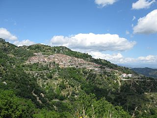
Santa Cristina d'Aspromonte is a comune in the Province of Reggio Calabria in the Italian region Calabria, located about 90 kilometres (56 mi) southwest of Catanzaro and about 30 kilometres (19 mi) northeast of Reggio Calabria. As of 31 December 2004, it had a population of 1,086 and an area of 23.1 square kilometres (8.9 sq mi).
Scido is a comune (municipality) in the Province of Reggio Calabria in the Italian region Calabria, located about 90 kilometres (56 mi) southwest of Catanzaro and about 30 kilometres (19 mi) northeast of Reggio Calabria. As of 31 December 2004, it had a population of 1,029 and an area of 17.7 square kilometres (6.8 sq mi).

Serrata is a comune (municipality) in the Province of Reggio Calabria in the Italian region Calabria, located about 60 kilometres (37 mi) southwest of Catanzaro and about 60 km northeast of Reggio Calabria. As of 31 December 2004, it had a population of 922 and an area of 21.8 square kilometres (8.4 sq mi).
Staiti is a comune (municipality) in the Province of Reggio Calabria in the Italian region Calabria, located about 110 kilometres (68 mi) southwest of Catanzaro and about 35 kilometres (22 mi) southeast of Reggio Calabria. As of 31 December 2004, it had a population of 335 and an area of 15.9 square kilometres (6.1 sq mi).
Stignano is a comune (municipality) in the Province of Reggio Calabria in the Italian region Calabria, located about 50 kilometres (31 mi) south of Catanzaro and about 80 kilometres (50 mi) northeast of Reggio Calabria. Stignano borders the following municipalities: Camini, Caulonia, Pazzano, Placanica, Riace, Stilo.
Terranova Sappo Minulio is a comune (municipality) in the Province of Reggio Calabria in the Italian region Calabria, located about 80 kilometres (50 mi) southwest of Catanzaro and about 35 kilometres (22 mi) northeast of Reggio Calabria. As of 31 December 2004, it had a population of 556 and an area of 9.0 square kilometres (3.5 sq mi).


