
A flood is an overflow of water that submerges land that is usually dry. In the sense of "flowing water", the word may also be applied to the inflow of the tide. Floods are an area of study of the discipline hydrology and are of significant concern in agriculture, civil engineering and public health. Human changes to the environment often increase the intensity and frequency of flooding, for example land use changes such as deforestation and removal of wetlands, changes in waterway course or flood controls such as with levees, and larger environmental issues such as climate change and sea level rise. In particular climate change's increased rainfall and extreme weather events increases the severity of other causes for flooding, resulting in more intense floods and increased flood risk.

A dam is a barrier that stops or restricts the flow of surface water or underground streams. Reservoirs created by dams not only suppress floods but also provide water for activities such as irrigation, human consumption, industrial use, aquaculture, and navigability. Hydropower is often used in conjunction with dams to generate electricity. A dam can also be used to collect or store water which can be evenly distributed between locations. Dams generally serve the primary purpose of retaining water, while other structures such as floodgates or levees are used to manage or prevent water flow into specific land regions.

In geography and geology, fluvial processes are associated with rivers and streams and the deposits and landforms created by them. When the stream or rivers are associated with glaciers, ice sheets, or ice caps, the term glaciofluvial or fluvioglacial is used.

A weir or low-head dam is a barrier across the width of a river that alters the flow characteristics of water and usually results in a change in the height of the river level. Weirs are also used to control the flow of water for outlets of lakes, ponds, and reservoirs. There are many weir designs, but commonly water flows freely over the top of the weir crest before cascading down to a lower level. There is no single definition as to what constitutes a weir, and one English dictionary simply defines a weir as a small dam.

The Assiniboine River is a 1,070-kilometre (660 mi) river that runs through the prairies of Western Canada in Saskatchewan and Manitoba. It is a tributary of the Red River. The Assiniboine is a typical meandering river with a single main channel embanked within a flat, shallow valley in some places and a steep valley in others. Its main tributaries are the Qu'Appelle, Souris, and Whitesand Rivers. For early history and exploration see Assiniboine River fur trade.
In hydrology, discharge is the volumetric flow rate of water transported through a given cross-sectional area. It includes any suspended solids, dissolved chemicals, or biologic material in addition to the water itself. Terms may vary between disciplines. For example, a fluvial hydrologist studying natural river systems may define discharge as streamflow, whereas an engineer operating a reservoir system may equate it with outflow, contrasted with inflow.

The Dujiangyan is an ancient irrigation system in Dujiangyan City, Sichuan, China. Originally constructed around 256 BC by the State of Qin as an irrigation and flood control project, it is still in use today. The system's infrastructure develops on the Min River (Minjiang), the longest tributary of the Yangtze. The area is in the west part of the Chengdu Plain, between the Sichuan Basin and the Tibetan Plateau. Originally, the Min would rush down from the Min Mountains and slow down abruptly after reaching the Chengdu Plain, filling the watercourse with silt, thus making the nearby areas extremely prone to floods. King Zhao of Qin commissioned the project, and the construction of the Dujiangyan harnessed the river using a new method of channeling and dividing the water rather than simply damming it. The water management scheme is still in use today to irrigate over 5,300 km2 (2,000 sq mi) of land in the region and has produced comprehensive benefits in flood control, irrigation, water transport and general water consumption. Begun over 2,250 years ago, it now irrigates 668,700 hectares of farmland. The Dujiangyan, the Zhengguo Canal in Shaanxi and the Lingqu Canal in Guangxi are collectively known as the "three great hydraulic engineering projects of the Qin."
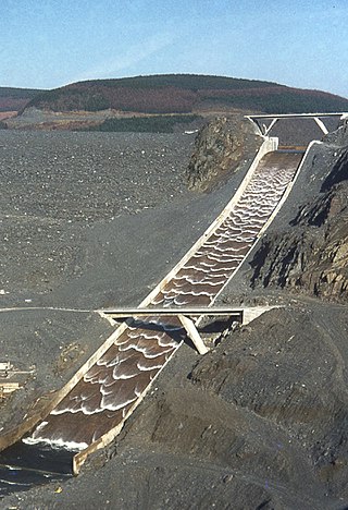
A spillway is a structure used to provide the controlled release of water downstream from a dam or levee, typically into the riverbed of the dammed river itself. In the United Kingdom, they may be known as overflow channels. Spillways ensure that water does not damage parts of the structure not designed to convey water.

The Yolo Bypass is one of the two flood bypasses in California's Sacramento Valley located in Yolo and Solano Counties. Through a system of weirs, the bypass diverts floodwaters from the Sacramento River away from the state's capital city of Sacramento and other nearby riverside communities.

Floodgates, also called stop gates, are adjustable gates used to control water flow in flood barriers, reservoir, river, stream, or levee systems. They may be designed to set spillway crest heights in dams, to adjust flow rates in sluices and canals, or they may be designed to stop water flow entirely as part of a levee or storm surge system. Since most of these devices operate by controlling the water surface elevation being stored or routed, they are also known as crest gates. In the case of flood bypass systems, floodgates sometimes are also used to lower the water levels in a main river or canal channels by allowing more water to flow into a flood bypass or detention basin when the main river or canal is approaching a flood stage.

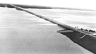
The Bonnet Carré Spillway is a flood control operation in the Lower Mississippi Valley. Located in St. Charles Parish, Louisiana, about 12 miles (19 km) west of New Orleans, it allows floodwaters from the Mississippi River to flow into Lake Pontchartrain and thence into the Gulf of Mexico. The spillway was constructed between 1929 and 1931, following the Great Mississippi Flood of 1927, and has been designated as a National Historic Civil Engineering Landmark by the American Society of Civil Engineers.

A reservoir is an enlarged lake behind a dam. Such a dam may be either artificial, usually built to store fresh water, or it may be a natural formation.

River engineering is a discipline of civil engineering which studies human intervention in the course, characteristics, or flow of a river with the intention of producing some defined benefit. People have intervened in the natural course and behaviour of rivers since before recorded history—to manage the water resources, to protect against flooding, or to make passage along or across rivers easier. Since the Yuan Dynasty and Ancient Roman times, rivers have been used as a source of hydropower. From the late 20th century, the practice of river engineering has responded to environmental concerns broader than immediate human benefit. Some river engineering projects have focused exclusively on the restoration or protection of natural characteristics and habitats.
Streamflow, or channel runoff, is the flow of water in streams and other channels, and is a major element of the water cycle. It is one runoff component, the movement of water from the land to waterbodies, the other component being surface runoff. Water flowing in channels comes from surface runoff from adjacent hillslopes, from groundwater flow out of the ground, and from water discharged from pipes. The discharge of water flowing in a channel is measured using stream gauges or can be estimated by the Manning equation. The record of flow over time is called a hydrograph. Flooding occurs when the volume of water exceeds the capacity of the channel.

The Ware River is a 35.4-mile-long (57.0 km) river in central Massachusetts. It has two forks, its West Branch, which begins in Hubbardston, Massachusetts, and its East Branch, which begins in Westminster, Massachusetts. The Ware River flows southwest through the middle of the state, joins the Quaboag River at Three Rivers, Massachusetts, to form the Chicopee River on its way to the Connecticut River.
The Morganza Spillway or Morganza Control Structure is a flood-control structure in the U.S. state of Louisiana. It is located along the western bank of the Lower Mississippi River at river mile 280, near Morganza in Pointe Coupee Parish. The spillway stands between the Mississippi and the Morganza Floodway, which leads to the Atchafalaya Basin and the Atchafalaya River in south-central Louisiana. Its purpose is to divert water from the Mississippi River during major flood events by flooding the Atchafalaya Basin, including the Atchafalaya River and the Atchafalaya Swamp. The spillway and adjacent levees also help prevent the Mississippi from changing its present course through the major port cities of Baton Rouge and New Orleans to a new course down the Atchafalaya River to the Gulf of Mexico. The Morganza Spillway, operated by the U.S. Army Corps of Engineers, was opened during the 1973 and 2011 Mississippi River floods.

A river is a natural flowing watercourse, usually a freshwater stream, flowing on the surface or inside caves towards another waterbody at a lower elevation, such as an ocean, sea, bay, lake, wetland, or another river. In some cases, a river flows into the ground or becomes dry at the end of its course without reaching another body of water. Small rivers can be referred to by names such as creek, brook, and rivulet. There are no official definitions for the generic term river as applied to geographic features, although in some countries or communities, a stream is defined by its size. Many names for small rivers are specific to geographic location; examples are "run" in some parts of the United States, "burn" in Scotland and Northeast England, and "beck" in Northern England. Sometimes a river is defined as being larger than a creek, but not always; the language is vague.

A check dam is a small, sometimes temporary, dam constructed across a swale, drainage ditch, or waterway to counteract erosion by reducing water flow velocity. Check dams themselves are not a type of new technology; rather, they are an ancient technique dating from the second century AD. Check dams are typically, though not always, implemented in a system of several dams situated at regular intervals across the area of interest.

The Sweetwater Dam is a dam across the Sweetwater River in San Diego County, California. It is located approximately 12 miles (19 km) east of San Diego, 9 miles (14 km) and borders Bonita to the southwest and La Presa to the northeast. The 108-foot (33 m)-high masonry arch dam impounds 960-acre (390 ha) Sweetwater Reservoir.

Zengwen Dam, also spelled Tsengwen Dam, is a major earthen dam in Dapu Township, Chiayi County, Taiwan on the Zengwen River. It is the third tallest dam in Taiwan, and forms Zengwen Reservoir (曾文水庫), the biggest reservoir in Taiwan by volume. The dam stores water for irrigation of the Chianan Plain, Taiwan's most productive agricultural region, and provides flood control along the Zengwen River which flows through Tainan City. The dam supports a 50 megawatt hydroelectric power station.

